Alabama-North Florida MapRaid ended on 09 Nov 2019 23:59:00 UTC. Please check back here for results and check the Mapraid Forum for mapraid announcements.
The MapRaid runs 27 October 2019, Midnight (CDT)/05:00 (UTC) - 09 November 2019, 23:59 UTC (approximately).
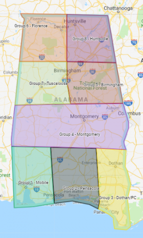
Welcome to the Alabama and North Florida MapRaid! This MapRaid (MR) committee has invited editors from across the world to come together for two weeks to edit these areas from the Southeast Region (SER) of Waze USA. We appreciate your contribution to this project, whether it's many edits to the map or just a few. Each and every one moves us one step forward towards reaching our goal: Fixing all Place-based issues on the map!
All participants will be granted the ability to edit within the complete MR area for the duration of the raid. Each of you will also be attached to a raid group and area (a subset of the entire MR region). Each raid group will be provided a list of editing priorities. As raiders, it will be your task to work with your group to help knock those issues off the map!
MISSION & PRIORITIES
Our mission for this MapRaid is to improve all Wazers' experiences in Alabama and North Florida. We want to make it easier to locate a specific place in search (with complete and accurate business / entity details) and arrive at the correct location in a timely manner! To do this, our primary goal is to update as many places as possible and to resolve any existing place-based routing issues on the map.
These are our editing priorities:
Place Points (PP), Area Places (AP), & Place Update Requests (PUR),
Residential Place Points (RPP),
Parking Lot Roads (PLR),
House Numbers (HN),
Map Problems (MP), and,
Parking Lot Areas (PLA). (Please work PLAs after priorities 1 - 5 have been addressed.)
Please read this entire MapRaid wiki.
If you are uncertain or have any questions, please consult with your group leaders.
BEYOND MAP RAID SCOPE
Please notify your group leader of any large issues you find. Any major issues which need to be addressed will be taken up by local editors after the MapRaid's conclusion. (For example, issues such as city name merging, large scale renaming (primary or alt), etc., will be handled later.)
There is a WME Form Filler AL/NoFL script that was created to populate a spreadsheet for local editors to use for resolutions. See WME Form Filler AL/NoFL script under the Customized Scripts section.
DO NOT EDIT:
• New Parking Lot Areas (PLA)
• Update Requests (UR)
Please leave the UR's for the Local Editors.
• Toll roads
• Functional Class (FC)
Do not make changes to road segment functional class. All roads should be current and set per state standards.
If you do find an issue, please notify your group leaders so it will be addressed after the MapRaid concludes.
• Cameras
New red light cameras are rare. (There are none currently in the MapRaid area.)
All communications for this MapRaid, will be in the Waze "Southeast" Discord server, within the "SER MAP RAID" category. English is the primary language for this raid and each raid group has a dedicated channel for its internal communications. For those raiders with limited access to Discord, a GHO bot is available for each raid group. (Specific instructions are posted in each group's channel.) ALL Unlocks/Locks will take place in your Group Channel.
Group 0 - Chat is open to all raiders. Feel free to hang out there and get acquainted, etc.
You are responsible for every edit you make, whether you make it by hand or use a script. Every edit made should meet the goals of this MapRaid and make a noticeable improvement to the map. Do not make edits simply to gain points without improving the map. (For example: if an area place polygon is "good enough" for the Waze map, do not edit it.) If it looks like you are making unnecessary edits or hunting for points, you may be banned from this MapRaid and from future MapRaids.
WME Settings
Review your WME settings and preferences to verify that North America only environment and US English is active.
Required Map Layers
Ensure these Layers in WME are enabled during MR editing:
Map Comments provide special information and/or guidance for that location (either a map point or area) .
Rank-based Editing Restrictions
Level 1 and Level 2 editor map editing restrictions remain in effect during the raid.
• interchanges/junctions • water of any kind • islands • beaches • toll plazas
We DO NOT maphome-based businesses. (No business places should be mapped inside neighborhoods.)
If you find any of these places already on the map,
PLEASE talk to your group leader before making any changes.
Mapping Style - Area or Point
In SER, the following place categories are mapped either as an area (AP) or as a point (PP) in exception to USA Places guidance:
Place type
Mapping Style
Place type
Mapping Style
City Hall
Area Place
Campground
Point Place
Government
Area Place
Car Dealership
Point Place
Library
Area Place
RV Park
Point Place
Museum
Area Place
Park
Area Place
Post Office
Area Place
Sports Court
Area Place
Area Places (APs) are drawn as basic polygons on the map:
APs are mapped to the parcel boundaries.
Gas stations are mapped to the fenceline or parcel boundaries.
Multi-building campuses, (e.g. schools, universities, large hospitals) are mapped as one large polygon inclusive of all parcel boundaries.
Parking Lot Areas (PLAs) cover the parking spots.
Place Marker & Entry Point Locations
Verify that the Place marker and entry point(s) are in the correct location on the map. (The entry point needs to be placed at the best spot for a route to end.)
• The place marker and entry point(s) guidelines for PPs are explained in this section of the USA Point Places wiki.
• The place marker should be placed over the front door of the place.
MapRaid editing is limited to places (stores, shops, or kiosks) INSIDE shopping malls. Please do not edit the shopping mall footprint or other attributes.
Name. Name the business/entity as shown on its own website (or, if none is available, from another approved source).
• Place located inside another Place. Append to the place name " ( "inside" other place name) ". (The WMEPH script will ignore the information inside the parenthesis and pull the correct harmonization information.)
• Gas Stations. Be sure to follow national guidance for how to name special cases.
Address. The address needs to be complete. It should have a house number, road name, city and state.
• For RPPs, use the "City" name from the United States Postal Service (USPS) mailing address.
• For all others places (PPs, APs, and PLAs,) the "City" name, and the rest of the address, is determined by the business or entity. Use the address shown on its official website.
Category. In general, SER follows the USA wiki place category guidelines. SER has localized guidance for the harmonization of specific businesses, Chain Harmonization Sheet, and category selection for certain types of businesses, Category Sheet. Contact your group leader if you have questions on which category to use.
Description. If there is additional information which a Wazer would find useful to know about the place, that can noted in the Description area.
Place Lock Level. The default lock level for places is Level 3.
Place type
Lock Level
Airports & their PLAs
5
Arenas
5
Colleges
5
Hospitals
5
Park & Ride Lots
5
Universities
5
Urgent Care
5
All Other Places ....(incl. PPs, APs, PLAs, RPPs)
3
External Provider. All places should have at least one google link.
- From WMEPH, press the 'Add' button adjacent to the 'No Google link' statement.
- For R2+ editors up-locking places ensure that if a Google Link is available that it is added to the place before up-locking.
- If WMEPH fails to find a link,
• Try entering variations in the name in the field under the External Providers section
• Check how the place is identified by Google on its map.
NOTE: Go to PLA section for special external provider guidance.
Place Details: More Info Tab
Telephone Number. Telephone numbers must be entered in one of these formats: (###) ###-#### or ###-###-####. (Use WMEPH and format will be formatted properly.)
Website.
1. Verify that the website IS owned by that business or entity. A Facebook page may only be used if the business does not have its own listing and the Facebook page is not "Unofficial".)
2. Verify that the URL works before adding it to a place in WME.
3. Use the URL that will take you directly to the homepage for the business or entity
• For public schools, enter the URL provided by the school. (They make extensive efforts to keep their naming schemes.
• For Businesses with multiple locations (chains or franchises e.g.), please use the simplest URL that will get you to the main or general business web page. (Please do not link directly to the a location-specific page.)
Services. Select all of the services which apply.
• Restaurants and Fast Food places should have Delivery selected if they have arrangements with DoorDash, FOODNOW, Uber Eats, etc.
• At a minimum, be sure to determine and note whether or not these services are present: Air Conditioning, Handicap Access, Customer Parking, and Restrooms.
Open Hours.
• If hours include words (and cannot be put here), please note what they are in the description.
• When the open hours vary because different services are offered (i.e. lobby vs. drive-thru), Add the hours set with ...... the greatest number of open hours to the place's open hours. Note the other hours in the description field.
Residential Point Places (RPP)
From the USA RPP wiki, please be sure that the following information is on the map:
• Correct, complete ADDRESS which includes a house number, street name, city, state, and country. (The "City" name originates from the United States Postal Service (USPS) mailing address.)
• Entry Point is present.
• The STREET name and CITY name from the RPP are also present on a nearby segment. The STREET name/CITY name MUST be together, or paired, either in the primary ADDRESS or in an alternate ADDRESS.
We suggest to work at Zoom = 7 (10 m / 50 ft) or closer.
(This makes it easy to verify that the location marker and entry point are in the correct locations.)
After clearing the PUR, run the WMEPH script to ensure that WMEPH has not identified any entries as potentially incorrect or missing.
Fix any issues identified. (No drive-bys, please.)
  Go beyond (WMEPH) GREEN !
      • Ensure that all readily available information for a place is entered on the map!
REMINDER - Add an external provider ONLY IF it is a separate link to the PARKING LOT. (DO NOT ADD an external provider link for a business served by the PLA.)
  Go beyond (WMEPH) GREEN !
      • Ensure that all readily available information for a place is entered on the map!
SEGMENT EDITING GUIDANCE
The Southeast region follows the USA guidance for editing Roads. Any exceptions or deviations from that are explained in the Southeast Region (SER) wiki. If you are uncertain or have questions about how to address something you see on the map, please ask your group leader.
Add driveways ONLY if needed to support routing for RPPs. SER follows the guidance in the USA Driveways wiki.
Do NOT map driveways less than 50 meters long.
Map driveways over 50 meters if:
Waze might confuse being on that driveway for being on an adjacent street or vice versa.
It has its own city assigned street name and at least one address is assigned to that name, regardless of length. However, note that driveway may actually be a street so mark accordingly.
House Numbers (HN)
Verifythat the HN marker and stop point is correctly placed on the map. SER follows the guidance in the USA House Number wiki. Be sure you are familiar with tips and warnings offered for house numbers in the things to remember section.
Segment Lock Level
When you have finished editing a segment, please ensure the lock level is set correctly. If you are unable to lock it to that level,please lock it as high as you can and ask your group leader to up-lock or raise the segment lock to the correct level.
If you believe a segment lock level is incorrect,
PLEASE talk to your group leader before making any changes.
The entire Southeast region (SER) observes the segment locking standards in the chart below.
There are some cases that do not adhere to this standard, such as any theme park type areas in Orlando (5/6). Further, all gates at gated communities / private installation should be locked to at least 5.
Standard for locking roads in the southeast region:
Segment Type
Default locks
Freeway
5
Ramp
5
Major Highway
5
Minor Highway
4
Primary Street
3
Street
1
• • • • Ferry • • • •
5
|-|-|-|-|-|-|-|-|-| Railroad |-|-|-|-|-|-|-|-|-|
2
Other roads may be locked higher for protection and special situations (areas with construction, tricky design, frequent mistakes, incorrect images, etc.).
The MR committee strongly suggests that you install and enable the following tools and scripts to assist you in meeting the MR goals. Many scripts and extensions exist which help editors make quality changes to the map with greater ease. (The USA wiki Script page lists and explains the features of some of the most popular ones available.)
Tools
• A script manager is required. We recommend the installation of TamperMonkey. (Some scripts do not work with the current version of GreaseMonkey.)
• WME MapRaid Overlays - Overlay shows editing boundaries for each MapRaid group.
• WME Place Browser - Creates a list of places requiring edits. Places are sorted by severity of issue.
• WME Form Filler AL/NoFL (Dev) - Uses info from WME to automatically fill out related forms - for the AL/NoFL MapRaid.
Place Editing Assistance
• WMEPH - Adds various checks and validation tools for places, as well as highlighting on the map for completeness. Full integration with USA Place Name Harmonization.
• WME PIE (aka PIE) - Various interface & functionality enhancements for Places.
• GIS Layers - Overlay shows HN and street name, physical location on map, & primary city name.
• GIS Buttons - (Google API required.) Active button(s) provide direct link to primary sources for HN and street name, physical location on map, & primary city name. Sources can provides leads for alternate city name. (Helpful when GIS Layer data is unavailable.)
• US Government Boundaries - Identify potential zip code to use with USPS lookup tool to determine alternate city name(s). (Be sure to enable zip code and county layers.)
Segment Editing Assistance
• WME Magic - Highlights potential problems with segments in WME for further investigation.


