Kartografer (talk | contribs) (added "see also" section on roads and runways) |
Kartografer (talk | contribs) m (Kartografer moved page User:Kartografer/Airport to Places/Airport: consensus reached at https://www.waze.com/forum/viewtopic.php?f=1636&t=226373) |
(No difference)
| |
Revision as of 19:27, 15 May 2017

Airports in the United States range from small non-towered facilities for general aviation up to large international hubs. Large airports are critical destinations for Waze users, due to traffic volume, complexity of roadways and the time-sensitive nature of commercial air travel. Regardless of size, this page will explain how to properly map, name and select stop points for airports and various other places within them, so that Waze users can quickly search and obtain accurate navigation for where they need to be, and so that airports display sensibly on the map. This page only applies to civilian airports; mapping of military airfields is covered under the military base page.
Area creation

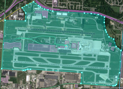
Each airport should be drawn as a single area place, covering all airport-managed property including open space, parking lots, runways, taxiways, terminal buildings, control towers, airport tenants, and other structures. This will ensure visibility on the map.
Names
Airports are referred to in various ways, using official names, abbreviated names, acronyms and location identifier codes. Official names are usually long (e.g. Hartsfield-Jackson Atlanta International Airport), so they are often abbreviated colloquially to a few words (e.g. Atlanta Airport) or letters (DIA for Denver International Airport). All airports in the United States have a location identifier assigned by the Federal Aviation Administration (FAA), which is three alphabetical or alphanumeric characters for public-use airports and four alphanumeric characters for private-use airports. Many public-use airports also have a four-letter location indicator from the International Civil Aviation Organization (ICAO). In the contiguous United States ICAO prefixes K to the alphabetical FAA identifier of an airport to create its ICAO code. In Alaska, Hawaii and US territories ICAO codes begin with other letters and are not directly related to the FAA identifier. Finally, most airports with commercial passenger operations in the US are assigned a three-letter identifier by the International Air Transport Association (IATA). This is often, but not always, identical to the FAA identifier. Since IATA codes are used by airlines in flight schedules and baggage handling, they are the most well-known airport codes.
Primary name
Use the official, long-form name as the primary name of the airport, followed by its IATA code in parentheses. If it doesn't have an IATA code, put the FAA identifier in parentheses. This creates the most straightforward and uniform display on the map, and since airports always occupy a large area, the length of the name does not cause display problems.
Examples:
Los Angeles International Airport (LAX)General Edward Lawrence Logan International Airport (BOS)St. Louis Lambert International Airport (STL)Ohio University Airport (ATO)Fairfield County Airport (LHQ)Hardin County Airport (I95)
Alternate names
To aid users in searching, add the following as alternate names:
- The IATA code, if the airport has one. Example:
DTWforDetroit Metropolitan Wayne County Airport (DTW)
- The ICAO code, if the airport has one. Example:
KBDUforBoulder Municipal Airport (WBU)
- The FAA identifier, if it is different from the IATA code. Example:
SAWforSawyer International Airport (MQT)
- Any commonly used local abbreviation that isn't part of its official name. Examples:
DIAforDenver International Airport (DEN)Sea-TacforSeattle-Tacoma International Airport (SEA)
- Any former name or names, if the name change was recent and/or the former name is still commonly used. Example:
Moisant FieldforLouis Armstrong New Orleans International Airport
Stop point

The stop point for the airport should be placed as follows:
- If the airport has one terminal accessible by one road, place the stop point at the terminal.
- If the airport has one entrance road and multiple terminals or one terminal with different roads leading to access for arrivals and departures, place the stop point at a location before any of the individual paths branch from the entrance road.
- If the airport has multiple entrance roads for multiple terminals, place the stop point at a location that is most helpful to the most passengers at the airport.
Other information
In the general tab, link all results from external providers that pertain to the airport in general. If the airport has just one terminal, also link external results that pertain to the terminal itself. Fill in all other relevant information, such as address, website and phone number.
Differentiated terminal places

If the airport has differentiated access for arrivals and departures, or if it has multiple terminals, additional point places should be added for these destinations. This enables users to obtain more specific navigation instructions. Name these places using the airport code in its primary name followed by a descriptor in title case. Examples include:
CMH DeparturesSFO Terminal 3DFW Terminal AJFK Terminal 4 Arrivals
Use of the airport code is important, since using a longer name could cause the descriptor to be cut off in the search results display. If an airport does not have an IATA code, use the FAA identifier in these names. Alternate names can include other names for the airport, along with the descriptor. Again add all relevant information, and link external results that pertain to these specific terminals or destinations.
Car rental
If car rental is offered at the airport, add point places for each car rental facility or return.
Unified car rental facility
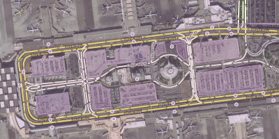
If rental companies share a common airport-owned facility, it's best to add that as one place and link external results for each of the rental companies there. Name common car rental facilities or returns in a similar way to terminals, using the airport code followed by a descriptor, for example CLT Rental Car Return. If there is an associated parking lot, add it according to the guidance on parking lots.
Individual car rental facilities
For separate company facilities located within or in the vicinity of the airport, the airport code may be appended at the end of the name after a hyphen, for example Avis - IAD. This applies even to car rental facilities that aren't within the airport area but provide shuttle service from the airport to their rental office. Add places where each airport-associated car rental facility is located. If there is an associated parking lot, add it according to the guidance on parking lots. Further, if all such separate facilities are located in a common area such as on a single stretch of road, add a single "rental car return" point place as defined in the previous subsection.
Parking
Add airport parking facilities in according with the parking lot page. Take note of the airport shuttle service and check this option for lots where a shuttle is provided.
Other associated places
Other places for businesses should be added at the airport, such as hotels, restaurants and fixed-base operators. Hotels usually have a local addendum to their name, which is especially important to use for airport hotels. If a business is located in a terminal before security, it can be mapped, but add "(inside XXX)" to the end of the name, where XXX is the airport code. If a business is located past security, it should not be mapped except to clear up confusion from an external place that shows up in Waze search. In that case, add the place to Waze and name it with (past security XXX), being sure to link the corresponding external place. This will help Wazers not to select it as a navigation destination.
Roads and runways
These elements are outside the scope of airport place guidance. See the article covering road types and runways for more information on mapping road segments within airports.