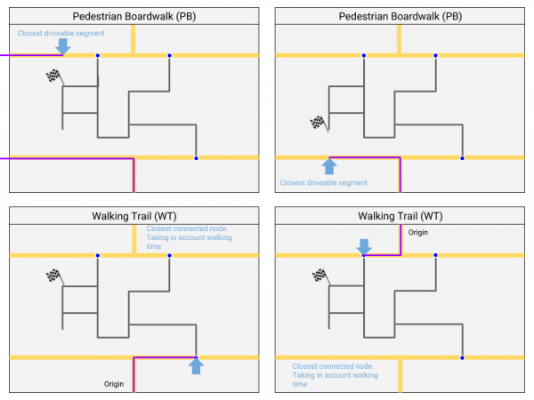
Non-drivable roads
The non-drivable road types are:
- Non-drivable roads - Not able to drive with a vehicle but with possible destinations.
- Non-drivable roads - Not able to drive with a vehicle and without destinations.
- Non-drivable roads
- Non-drivable roads
Non-drivable roads like walking trails and pedestrian boardwalks shouldn't be added, unless there is a good reason. Check the Wiki pages on these road types: Non-drivable roads and Non-drivable roads.
Not or not always drivable
We often get the question "how do we map non-drivable or restricted access roads?" In the table below you will see what to do in every situation.
| Road type | Description |
|---|---|
| Non-drivable roads | Not able to drive with a vehicle Possible destination along the segment |
| Non-drivable roads | Not able to drive with a vehicle Does not have any destinations along the segment |
| Private road | Able to drive with a vehicle Not always allowed to drive with a car |
| Street with restriction | Access restricted for certain vehicle types Access restricted for certain hours of the day |
Non drivable roads
Walking Trail or Pedestrian Boardwalk
Destination
If a footpath leads from a normal road to a Walking Trail, but this path has no destinations / house numbers,
should it be defined as PB or is a PB skipped in the routing and should we take WT without house numbers?
Best use a WT, see picture below.

Public transport
The previous standard "Use Walking trails for public transport" is changed into "use Non-drivable roads for public transport". because both non-drivable roadtypes have now a fix. Preference for PB because public transport lanes shouldn’t have (by accident) destinations.

