(Importing a new version from external source) |
WTranlatebot (talk | contribs) (Updating to match new version of source page) |
||
| Line 21: | Line 21: | ||
<th align=left>Road type</th><th align=left>Description</th> | <th align=left>Road type</th><th align=left>Description</th> | ||
<tr><td valign=top>[[Walking trail]]</td><td>Not able to drive with a vehicle<br />Possible destination along the segment<br /> | <tr><td valign=top>[[Walking trail]]</td><td>Not able to drive with a vehicle<br />Possible destination along the segment<br /> | ||
Considered for routing if connected via a real [[Nodes|junction node]]</td></tr> | Considered for routing if connected via a real or Phantom [[Nodes|junction node]]</td></tr> | ||
<tr><td valign=top>[[Pedestrian Boardwalk]]</td><td>Not able to drive with a vehicle<br />Does not have any destinations along the segment<br /> | <tr><td valign=top>[[Pedestrian Boardwalk]]</td><td>Not able to drive with a vehicle<br />Does not have any destinations along the segment<br /> | ||
Not considered for routing, connect only via <i>[[Nodes|phantom nodes]]</i>.</td></tr> | Not considered for routing, connect only via <i>[[Nodes|phantom nodes]]</i>.</td></tr> | ||
Revision as of 12:00, 22 May 2020
Routes non Carrossables
The non-drivable road types are:
- Non-drivable roads - Not able * to drive with a vehicle but with possible destinations.
- Non-drivable roads - Not able * to drive with a vehicle and without destinations.
- Non-drivable roads
- Non-drivable roads
* Not able means in this context not able or not allowed. On many foot paths and bicycle paths it is physical possible to drive with a car or motor cycle, but these road types shouldn't be used by this type of traffic.
Page on the Locking level of non-drivable roads.
Use sparcely
Non-drivable roads like walking trails and pedestrian boardwalks shouldn't be added, unless there is a good reason. Check the Wiki pages on these road types: Non-drivable roads and Non-drivable roads.
Not or not always drivable
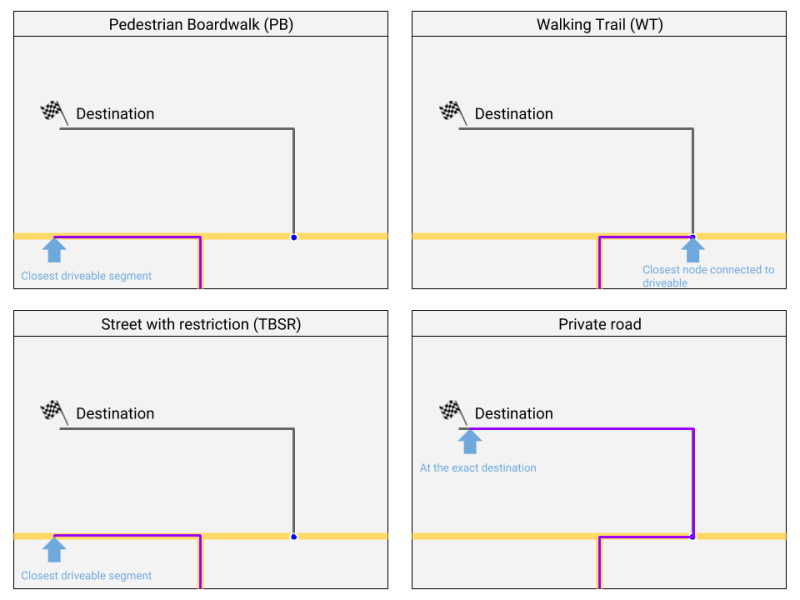
We often get the question "how do we map non-drivable or restricted access roads?" In the table below you will see what to do in every situation.
| Road type | Description |
|---|---|
| Non-drivable roads | Not able to drive with a vehicle Possible destination along the segment Considered for routing if connected via a real or Phantom junction node |
| Non-drivable roads | Not able to drive with a vehicle Does not have any destinations along the segment Not considered for routing, connect only via phantom nodes. |
| Private road | Able to drive with a vehicle Not always allowed to drive with a car |
| Street with restriction | Access restricted for certain vehicle types Access restricted for certain hours of the day |
Walking Trail or Pedestrian Boardwalk
Destination
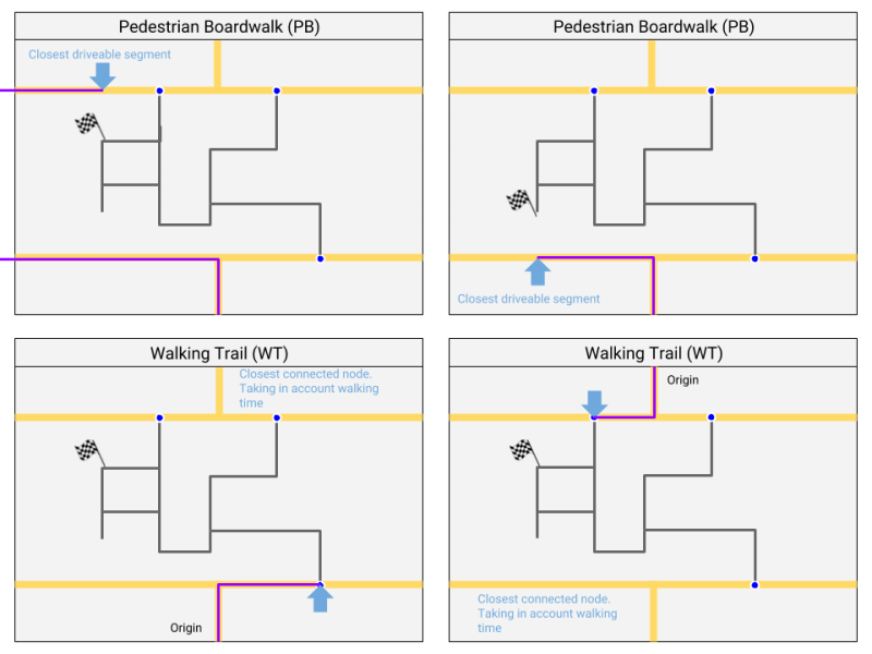
If a footpath leads from a normal road to a Walking Trail, but this path has no destinations / house numbers,
should it be defined as PB or is a PB skipped in the routing and should we take WT without house numbers?
Best use a WT, see picture below.
Public transport
The previous standard "Use Walking trails for public transport" is changed into "use Non-drivable roads for public transport". because both non-drivable roadtypes have now a fix. Preference for PB because public transport lanes shouldn’t have (by accident) destinations. But Non-drivable roads should not be chosen if they can be used by taxis.
Belgium F99 sign

Belgium uses the F99 sign in a number of variants. The road is allowed for the type of traffic that is displayed on the sign. If this sign is used we've got the following mapping possibilities:
- If there are houses or other destinations along the segment (house numbers), then a Private Road is used. Possibly to be completed with unpaved checked.
- If there are no destinations the road should be mapped as a Non-drivable roads.
- If necessary, the road can be divided into a part with habitation (Private Road) and a part without habitation (Pedestrian Boardwalk).
- Speed limit is 30km/u.


