No edit summary |
No edit summary |
||
| Line 37: | Line 37: | ||
==Speed Limits That Should be Recorded== | ==Speed Limits That Should be Recorded== | ||
[[File:30-mph-uk.jpg|thumbnail|UK speed limit sign | [[File:30-mph-uk.jpg|100px|thumbnail|UK speed limit sign]] | ||
===Fixed Regulatory Speed Limits=== | ===Fixed Regulatory Speed Limits=== | ||
All speed limits in the UK are shown using circular signs with a red border and black text. These should be visible using StreetView. | All speed limits in the UK are shown using circular signs with a red border and black text. These should be visible using StreetView. | ||
[[File:UK-NSL-sign.jpg|100px|thumbnail|UK national speed limit sign]] | |||
====National Speed Limit==== | ====National Speed Limit==== | ||
'''Note:''' Waze does not support speed limits for different vehicle type so all speed limits should be set to that applicable to Cars. Motorcycles, & Vans. | '''Note:''' Waze does not support speed limits for different vehicle type so all speed limits should be set to that applicable to Cars. Motorcycles, & Vans. | ||
| Line 55: | Line 57: | ||
|} | |} | ||
===Private Speed Limits=== | ===Private Speed Limits=== | ||
Private roads do not need to be recorded, but if the speed limit sign is clearly visible then having it recorded will give the best experience to Wazers. | |||
==Speed Limits that should not be recorded== | ==Speed Limits that should not be recorded== | ||
[[File:Uk-advisory-sl.jpg|150px|thumbnail|UK minimum speed limit sign]] | |||
===Advisory Speed Limits=== | ===Advisory Speed Limits=== | ||
Advisory speed limits, often found on sharp bends, school zones, are not legally enforceable so these are not mapped in the WME. | |||
===Temporary Speed Limits=== | ===Temporary Speed Limits=== | ||
===Time-based Speed Limits=== | ===Time-based Speed Limits=== | ||
[[File:UK-min-speed-limit.jpg|100px|thumbnail|UK minimum speed limit sign]] | |||
===Minimum Speed LImits=== | ===Minimum Speed LImits=== | ||
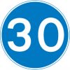
WME does not have the ability to record a minimum speed limit so these should not be mapped. Only Maximum speed limits should be recorded. | |||
Revision as of 14:41, 13 March 2017
Introduction
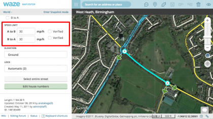
Speed limit information for a given road can be added to each segment within the WME. This speed limit information is used by the client App to compare the Wazer's actual speed relative to the known speed limit, alerting them when they exceed the speed limit set within WME. The speed limit set by an editor does not influence routing in any way.
Reporting a speed limit in the App
There are currently 2 methods to report an incorrect or missing speed limit:
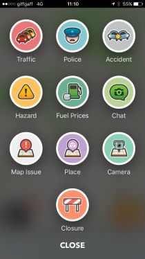
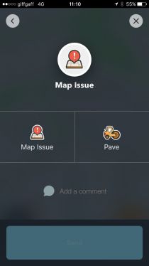
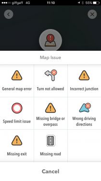
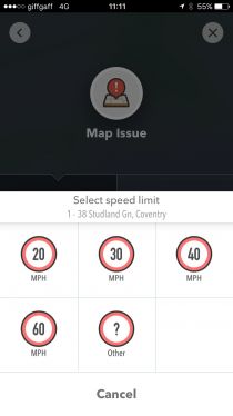
1. Tap the Report button in the lower right corner > Tap Map Issue > Tap Map Issue again> Tap Speed limit issue > Select the speed you wish to report > Tap Send.
 |
 |
 |
 |
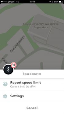
2. Tap the Speedometer button in lower left corner > Tap Report speed limit > Select the speed you wish to report.
 |
 |
Both methods send a Speed Limit Update Request that can be reviewed and actioned within the WME.
Speed Limit Update Requests
| SLURs are currently not visible in the production version of WME (March 2017) |
Setting Speed Limits
| Make sure you have the correct units set! Having metric selected does not work well with mph. |
| You may wish to use the WME Color Speeds script to help visualise which speed limits have been set already. |
Speed Limits That Should be Recorded

Fixed Regulatory Speed Limits
All speed limits in the UK are shown using circular signs with a red border and black text. These should be visible using StreetView.

National Speed Limit
Note: Waze does not support speed limits for different vehicle type so all speed limits should be set to that applicable to Cars. Motorcycles, & Vans. You can not mark a segment as being covered by the National Speed Limit. Instead you must added the numerical limit that applies to that road type.
| Built up areas | Single carriageways | Dual carriageways | Motorways |
| A road which has street lighting is generally limited to 30 mph unless otherwise specified. | A single carriageway road can have 1 or more lanes for travelling in either direction and is generally limited to 50 mph unless otherwise specified. | A dual carriageway road can have 1 or more lanes for travelling in either direction, each direction is separated with a central reservation, and is generally limited to 70 mph unless otherwise specified. | Motorways, as defined by the rectangular blue signs with white text are generally limited to 70 mph unless otherwise specified. |
Private Speed Limits
Private roads do not need to be recorded, but if the speed limit sign is clearly visible then having it recorded will give the best experience to Wazers.
Speed Limits that should not be recorded

Advisory Speed Limits
Advisory speed limits, often found on sharp bends, school zones, are not legally enforceable so these are not mapped in the WME.
Temporary Speed Limits
Time-based Speed Limits
Minimum Speed LImits
WME does not have the ability to record a minimum speed limit so these should not be mapped. Only Maximum speed limits should be recorded.
