mNo edit summary |
(added images) |
||
| Line 2: | Line 2: | ||
===Level 5=== | ===Level 5=== | ||
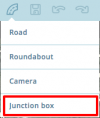
[[File:Junction-box.png|100px|thumbnail]] | |||
====Junction Boxes==== | ====Junction Boxes==== | ||
*'''Location:''' Within the [[File:DrawRoads.jpg|frameless|alt=add road]] menu. | *'''Location:''' Within the [[File:DrawRoads.jpg|frameless|alt=add road]] menu. | ||
| Line 8: | Line 9: | ||
===Level 4=== | ===Level 4=== | ||
[[File:Snapshot-mode.png|100px|thumbnail]] | |||
====Snapshot mode==== | ====Snapshot mode==== | ||
*'''Location:''' Top left of WME window, above the user profile. | *'''Location:''' Top left of WME window, above the user profile. | ||
| Line 16: | Line 18: | ||
*'''Function:''' Adds a new name to the City database. | *'''Function:''' Adds a new name to the City database. | ||
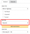
[[File:Routing-option.png|100px|thumbnail]] | |||
====Routing option==== | ====Routing option==== | ||
*'''Location:''' Within segment side-panel below ''Road Type''. | *'''Location:''' Within segment side-panel below ''Road Type''. | ||
| Line 22: | Line 25: | ||
===Level 3=== | ===Level 3=== | ||
[[File:Link-google-place.png|100px|thumbnail]] | |||
====Add Google linked place==== | ====Add Google linked place==== | ||
*'''Location:''' Within the Place's info panel under ''External Providers''. | *'''Location:''' Within the Place's info panel under ''External Providers''. | ||
*'''Location:''' Links a Google Maps entry to the Waze Place to improve routing. | *'''Location:''' Links a Google Maps entry to the Waze Place to improve routing. | ||
[[File:Add-closure-button.png|100px|thumbnail]] | |||
====Real time closures==== | ====Real time closures==== | ||
*[[global:Real_time_closures|Wazeopedia]] | *[[global:Real_time_closures|Wazeopedia]] | ||
*'''Location:''' Within the segment's info panel under ''Closures'' tab. | *'''Location:''' Within the segment's info panel under ''Closures'' tab. | ||
*'''Function:''' Allows real time closures to be set that are immediately live on the map. This still respects auto locks on segments. | *'''Function:''' Allows real time closures to be set that are immediately live on the map. This still respects auto locks on segments. | ||
Revision as of 06:56, 11 March 2017
Separate to the lock system used to protect the map some features of the WME are restricted until you reach a certain Editor Rank. The rank these features become available has been discussed and decided by the UK Country Admins.
Level 5

Junction Boxes
Level 4

Snapshot mode
- Location: Top left of WME window, above the user profile.
- Function: Allows the editor to see the current live map to review changes made after the most recent tile update.
Create new city names
- Location: Popup when unknown name is entered into the segment name field.
- Function: Adds a new name to the City database.

Routing option
- Location: Within segment side-panel below Road Type.
- Function: Upgrades / downgrades a segment without having to change it's Road Type.
Level 3

Add Google linked place
- Location: Within the Place's info panel under External Providers.
- Location: Links a Google Maps entry to the Waze Place to improve routing.

Real time closures
- Wazeopedia
- Location: Within the segment's info panel under Closures tab.
- Function: Allows real time closures to be set that are immediately live on the map. This still respects auto locks on segments.