m (formatting) |
Kkervinjones (talk | contribs) No edit summary |
||
| (8 intermediate revisions by 2 users not shown) | |||
| Line 31: | Line 31: | ||
===Setting difficult turns=== | ===Setting difficult turns=== | ||
*'<nowiki/>''' | *'''L'''<nowiki/>'''ocation:''' Within the ''Time Based Restrictions'' screen for each turn arrow. | ||
*'<nowiki/>''' | *'''F'''<nowiki/>'''unction:''' Marks a turn as ''difficult'', the App can be set to avoid these when routing. | ||
[[File:Add-closure-button.png|100px|thumbnail|alt=|Add Real Time Closure]] | [[File:Add-closure-button.png|100px|thumbnail|alt=|Add Real Time Closure]] | ||
| Line 41: | Line 41: | ||
*'''Function:''' Allows [[global:Real_time_closures|real time closures]] to be set that are immediately live on the map. This still respects auto locks on segments. | *'''Function:''' Allows [[global:Real_time_closures|real time closures]] to be set that are immediately live on the map. This still respects auto locks on segments. | ||
== | ===Lane guidance=== | ||
*'''Location:''' | *'''Location:''' Within the segment's info panel under ''Lanes'' tab. | ||
*'''Function:''' | *'''Function:''' Set the lane guidance choices for a segment. | ||
==Rank 4== | |||
[[File:Routing-option.png|100px|thumbnail|alt=|Change routing option]] | |||
===Create new city names=== | ===Create new city names=== | ||
| Line 53: | Line 53: | ||
*'''Function:''' Adds a new name to the City database. | *'''Function:''' Adds a new name to the City database. | ||
===Routing option=== | ===Routing option=== | ||
| Line 59: | Line 58: | ||
*'''Function:''' Upgrades / downgrades a segment without having to change its Road Type. | *'''Function:''' Upgrades / downgrades a segment without having to change its Road Type. | ||
=== | [[File:Junction-box.png|100px|thumbnail|alt=|Add a Junction box]] | ||
===Junction Boxes=== | |||
*'''Location:''' | *'''Location:''' Within the ''Road'' menu. | ||
*'''Function:''' | *'''Function:''' Allows better control of routing through complex junction and set Far Lanes guidance. | ||
==Rank 5== | ==Rank 5== | ||
[[File: | [[File:Path_button.png|100px|thumbnail|alt=|Paths Button]] | ||
=== | |||
=== Paths (Far Lanes 2) === | |||
*'''Location:''' | * '''Location:''' With Paths layer switched on add Paths from one segment to another | ||
*'''Function:''' Allows | *'''Function:''' Allows setting Paths over several segments to map (including nested) Far Lane Guidance. | ||
==Rank 5 (Country Manager)== | ==Rank 5 (Country Manager)== | ||
===Rename City=== | ===Rename City=== | ||
*'''Location:''' With the City layer turned on, and the City name additional option enabled. Select the city name and edit icon on right of panel. | *'''Location:''' With the City layer turned on, and the City name additional option enabled. Select the city name and edit icon is on right of panel. | ||
*'''Function:''' Allows the editing of an entire City name without touching individual segments or leaving the old name lingering in the servers. | *'''Function:''' Allows the editing of an entire City name without touching individual segments or leaving the old name lingering in the servers. | ||
==Rank 6== | |||
===Restricted Areas=== | |||
*'''Location:''' Within the top menu bar. | |||
*'''Function:''' Allows the editing of a Restricted Area by setting vehicle / time restrictions (similar to <abbr title="Time Based Restrictions">TBRs</abbr>), and associate passes. Currently the UK has the London CCZ & ULEZ mapped. The expected implementation of [[Congestion and Clean Air Zones|Clean Air Zones]] will also use this feature. | |||
[[Category:Reference]] | [[Category:Reference]] | ||
Latest revision as of 15:50, 5 November 2022
Introduction
Separate to the lock system used to protect the map some features of the WME are restricted until you reach a certain Editor Rank. The rank these features become available has been discussed and decided by the UK Country Admins.
Rank 2
Closing any URs, MPs
- Location: Ensure the relevant options are visible in the layers menu.
- Function: Allowed to close URs & MPs created by any users and themselves.
Deleting segments
- Function: Allowed to delete any segment not created by themselves (respecting lock levels).
Approve Places
- Location: Ensure that Place Update Requests are visible in the layers menu.
- Function: Approve new or edited Places that have been submitted via Place Update Requests.

Add Google linked place
- Location: Within the Place's info panel under External Providers.
- Function: Links a Google Maps entry to the Waze Place to improve routing.
Force House Numbers
- Location: Within the House Number interface.
- Function: When entering house number into the WME the system checks for errors like out of sequence, invalid numbers etc. Some of these can be forced saved if it is deliberate.
Rank 3
Setting difficult turns
- Location: Within the Time Based Restrictions screen for each turn arrow.
- Function: Marks a turn as difficult, the App can be set to avoid these when routing.

Real time closures
- Location: Within the segment's info panel under Closures tab.
- Function: Allows real time closures to be set that are immediately live on the map. This still respects auto locks on segments.
Lane guidance
- Location: Within the segment's info panel under Lanes tab.
- Function: Set the lane guidance choices for a segment.
Rank 4

Create new city names
- Location: Popup when unknown name is entered into the segment name field.
- Function: Adds a new name to the City database.
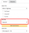
Routing option
- Location: Within segment side-panel below Road Type.
- Function: Upgrades / downgrades a segment without having to change its Road Type.

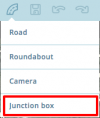
Junction Boxes
- Location: Within the Road menu.
- Function: Allows better control of routing through complex junction and set Far Lanes guidance.
Rank 5
Rank 5 (Country Manager)
Rename City
- Location: With the City layer turned on, and the City name additional option enabled. Select the city name and edit icon is on right of panel.
- Function: Allows the editing of an entire City name without touching individual segments or leaving the old name lingering in the servers.
Rank 6
Restricted Areas
- Location: Within the top menu bar.
- Function: Allows the editing of a Restricted Area by setting vehicle / time restrictions (similar to TBRs), and associate passes. Currently the UK has the London CCZ & ULEZ mapped. The expected implementation of Clean Air Zones will also use this feature.
