(Page creation) |
mNo edit summary |
||
| (2 intermediate revisions by 2 users not shown) | |||
| Line 4: | Line 4: | ||
===Triangular Junctions=== | ===Triangular Junctions=== | ||
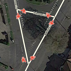
[[File:Triangle-junction.png | right | thumb | [[File:Triangle-junction.png | right | thumb | Turn restrictions at a triangle junction]] | ||
'''Reason:''' We have quite a lot of "triangle junctions" in the UK. Some of them are so small they have nothing more than a few square metres of grass in the middle and can probably be simplified into T-junctions. If they're left as triangles, they can be problematic. For any route through the junction, there are 2 possibilities: the "sensible" route following one side of the triangle; and the "silly" route following 2 sides. Because the triangles generally aren't very big, GPS accuracy isn't good enough to distinguish which route a driver actually takes. So if Waze decides a silly route is faster, then for most drivers who ignore it and take the sensible route, Waze will still think they've gone the long way round and reinforce that route. | '''Reason:''' We have quite a lot of "triangle junctions" in the UK. Some of them are so small they have nothing more than a few square metres of grass in the middle and can probably be simplified into T-junctions. If they're left as triangles, they can be problematic. For any route through the junction, there are 2 possibilities: the "sensible" route following one side of the triangle; and the "silly" route following 2 sides. Because the triangles generally aren't very big, GPS accuracy isn't good enough to distinguish which route a driver actually takes. So if Waze decides a silly route is faster, then for most drivers who ignore it and take the sensible route, Waze will still think they've gone the long way round and reinforce that route. | ||
'''Solution:''' | '''Solution:''' If a triangle is large enough to be mapped (e.g. has grass or a tree on it), then restrict all internal turns to force Waze to use the sensible route through these junctions. | ||
| Line 14: | Line 13: | ||
===Airport Routing=== | ===Airport Routing=== | ||
[[File:Bhx-airport.png | right | thumb | [[File:Bhx-airport.png | right | thumb | PLR segment at BHX]] | ||
'''Reson:''' Before Waze enable the ability to link Google Map locations to the Place created in WME, Waze had issues routing to places such as airports due to their size. The Google Maps location would usually be in the centre of the airfield and Waze would route to the nearest segment, frequently on the wrong side of the airport. | '''Reson:''' Before Waze enable the ability to link Google Map locations to the Place created in WME, Waze had issues routing to places such as airports due to their size. The Google Maps location would usually be in the centre of the airfield and Waze would route to the nearest segment, frequently on the wrong side of the airport. | ||
| Line 23: | Line 22: | ||
===Junction Shields=== | ===Junction Shields=== | ||
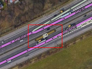
[[File:Road-shield-marker.png | right | thumb | | [[File:Road-shield-marker.png | right | thumb | Legacy junction number shield segment]] | ||
'''Reason & Solution:''' These segments sit within a junction that has a number, usually on Motorways, and create a shield icon within the App to give better visual guidance while driving. | <s>'''Reason & Solution:''' These segments sit within a junction that has a number, usually on Motorways, and create a shield icon within the App to give better visual guidance while driving.</s> | ||
This is now a legacy mapping feature as the member of Staff who coded this has left and HQ are unable to figure out how it worked... These segments can be removed from the map, Oct 2020. | |||
Latest revision as of 09:22, 29 October 2020
| There are no silly questions when editing in Waze, it is always better to ask a question and get an obvious answer than edit without being sure and potentially making a bad edit. |
Over the years several edits have been created in WME to either fix a routing issue or bring an improvement to the user experience. This is a collection of these edits to explain why they are present.
Triangular Junctions

Reason: We have quite a lot of "triangle junctions" in the UK. Some of them are so small they have nothing more than a few square metres of grass in the middle and can probably be simplified into T-junctions. If they're left as triangles, they can be problematic. For any route through the junction, there are 2 possibilities: the "sensible" route following one side of the triangle; and the "silly" route following 2 sides. Because the triangles generally aren't very big, GPS accuracy isn't good enough to distinguish which route a driver actually takes. So if Waze decides a silly route is faster, then for most drivers who ignore it and take the sensible route, Waze will still think they've gone the long way round and reinforce that route.
Solution: If a triangle is large enough to be mapped (e.g. has grass or a tree on it), then restrict all internal turns to force Waze to use the sensible route through these junctions.
Airport Routing

Reson: Before Waze enable the ability to link Google Map locations to the Place created in WME, Waze had issues routing to places such as airports due to their size. The Google Maps location would usually be in the centre of the airfield and Waze would route to the nearest segment, frequently on the wrong side of the airport.
Solution: A PLR was drawn from the correct destination to the point of the Google Map location, this would then route wazers to the correct entrance. Now L3+ editors can link the Google Maps location to the Waze place to ensure Wae routes to the correct entrance.
Junction Shields

Reason & Solution: These segments sit within a junction that has a number, usually on Motorways, and create a shield icon within the App to give better visual guidance while driving.
This is now a legacy mapping feature as the member of Staff who coded this has left and HQ are unable to figure out how it worked... These segments can be removed from the map, Oct 2020.