| This new page is currently undergoing modifications. The information and guidance is currently considered accurate enough to be followed now. Content is being prepared by one or more users. Do not make any changes before you post a message in this forum. |
Places are searchable destinations in the Waze map. They are similar to the "Points of Interest" found in certain popular GPS devices.
Area Places appear as polygons in the Waze app. Too many of them can clutter the map, creating large gray zones that do not help Wazers orient themselves. Therefore, it is important to use area places only when they are distinctive and significant enough to orient drivers, exceptions include gas stations, and parking lots which receive special handling.
Point Places don't appear on the Waze app map. They can be used to help Wazers find private homes and public places, especially when they are not already listed in the other destination search engines.
Residential Point Places don't appear on the Waze app map. They can be used for help Wazers find addresses by searching; can be used for residences or businesses.
The table of place categories and types, provides guidelines to help map editors decide between point and area places.
| Some of the guidance for Places may have specific localized adjustments for your local area. Be sure to familiarize yourself with these differences through the Local vs national guidance page. |
Point Place
In the Waze Map Editor, the appearance of a point place reflects its status:
![]() Selected Point marker (size reduced for readability)
Selected Point marker (size reduced for readability)
![]() Point Place with pending update
Point Place with pending update
Point Location Details
- The Point marker for a Place should be located on or nearest to the segment to which the driver should be navigated. The Point Marker is the stop point.
Area Place
The Area Place is a polygon. Use the geometry points to adjust the shape. Area Places are pink when not selected, blue-green when selected, and a reddish color when they have unsaved changes.
Area Location Details
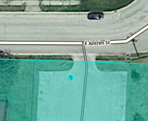
- The navigation stop point appears as a target in the editor.
- The target stop point can be moved anywhere within and a short distance outside the polygon.
- The stop point should be placed on or near the segment where the Wazer should stop.
Area Place size
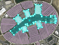
Area places will show up in the Waze mobile app if they are large enough.
Some area places have a single recognizable structure useful as a visual reference for Wazers as they approach this destination from various directions. Subject to the constraints on area places discussed elsewhere on this page, the area place can be drawn to approximate the structure's footprint or outline, provided that the structure has:
- a meaningful name that is at least locally well known
- a size large enough to show in the mobile application
Examples include landmark buildings like the Pentagon, as well as large shopping malls or stadiums/arenas that are constructed as single buildings.
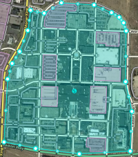
Other area places, like university campuses and town-center-style shopping malls (mixed-use developments designed for outdoor pedestrian access), include more than one component of interest, such as multiple buildings, open areas, roads, and parking. In this case, it is often most useful to Wazers to map to the edges of the property. This will usually show the area and its label in the mobile app even when zoomed out.
Guidelines for drawing a few specific categories are more detailed and should be reviewed.
Area Places overlap
Sometimes a large area place has smaller area places within it. Examples include different medical buildings within a hospital campus or separate malls within a large shopping complex. Currently, Waze will show the labels of the smaller area place, but not the boundaries within the larger area, unless the color is different. It may be a better approach for the time being to use point places for the components of a larger area place unless it is essential that the subset place names be visible. Future versions of the Waze client may render overlapping area places more usefully. Qualifying point places may be converted to area Places at that time.
Residential point places
Residential Point Places (RPPs) are used for when an address (residential address or business address) is not navigable from the main road. Houses that are on a private road/pipestem, businesses that have a vanity address on a major road (but their entrance is on another named lesser road), or businesses that are on parking lot roads within a shopping center are some examples.
RPPs:
- Appear as triangles in the app
- Are searchable by address if city matches the search
- Any name on a place that becomes an RPP disappears after saving and is not searchable
- Cannot be converted to a place point or place area (after saving)
- Appear in the app search usually within minutes
- Are a very high priority in an address search hierarchy
- Can only have one city for the house number (if more than one city name is used then multiple RPPs are required)
- Display in history who created the RPP and any edits after creation
See differences between House numbers and Residential place points for comparison to HNs. There are different advantages and disadvantages to each.
Creating an RPP
- Hover over the Place button on the grey tool bar on top of the WME screen
- Next to any category, preferably Other, click the point option
- Click at the location that the RPP is desired
- In the edit box to the left:
- Click on the ADDRESS pill
- Add the STREET name
- Add the HOUSE NUMBER
- Add the CITY (USPS mailing address city or city that the business uses if different)
- Click "Apply" button to prepare the ADDRESS information to save
- Click "Add point" button for ENTRY/EXIT POINTS
- Place the point where the user's navigation should end
- Lock to appropriate region standard, or your highest available level if you cannot lock to the regional standard
- Click "Convert to residential" button
- Note NAME, CATEGORIES, TYPE, EXTERNAL PROVIDERS, and More info tab options disappear
- This information is removed after saving, not merely hidden
- Click the Save button in the upper right corner of the grey toolbar
- Make sure a nearby segment has the exact same street and city name combination either as a primary name or an alternate name.
- If an existing saved house number's (HN) anchor position is >50 m away from the proposed position of a new RPP triangle, then the RPP will not save. Delete the HN and wait until the HN database updates (generally at least two tile updates) to retry saving this as an RPP. The proposed RPP can either be saved in the correct location as a point place (with name added, should be converted to RPP after HN update) or as an RPP within 50 m of the HN anchor location (should be moved to correct location after the HN update). It is recommended that a map comment be put over the RPP to both remind editors to fix it and to easily find the area again.
| RPPs will not work if they do not have the house number, street name, and city name. Additionally the exact street/city name combination should be specified on a nearby segment (primary or alternate name). They may not route correctly without an entry point. |
Client rendering of Places
Most area Places will show in the Waze app and Live map as a shaded area. Extremely small area Places will not appear at all, even at maximum zoom.
Point Places are not shown in the Live map, or Waze app, but are searchable within the app. By default, a Waze Place search result should supersede others, even in the autofill list.
Setting the stop point for a Place
Point placement
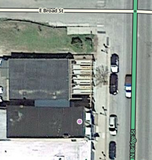
The Point Place should go on or very near to the segment to which the driver should be navigated. The Waze routing server will navigate the Wazer onto the segment which is physically closest to where the point is placed. The Point Marker is the stop point unless a stop point has been added. Typically, if the Place is inside a building, the marker should be located at or near the location's front door. Think: where would a car stop to drop someone off for this location. When moving a stop point, the editor will show a dashed black line boundary. The stop point must be placed within this boundary box as shown below.
Moving a Point Place
To move a point Place, first click on the Place icon, which will turn into the icon below. Now you can click and drag the Place to the correct location.
Note: You should also be sure to move the stop point for the place, if one has been added.

Point placement examples
Some examples
- A building with one Point Place:
- If there is only one door, place it at that door.
- If there are multiple doors on the same side, (like a supermarket,) place it at the point equidistant from and collinear with the two front doors.
- If there are multiple doors on different sides, (like some mall anchor stores,) if there's no "obvious" front door, place it either at the door facing the largest parking lot or at the door facing the street on which the street address for that location is.
- A single building with multiple Point Places within:
- At a strip mall, put each store's point at the store's "front door".
- At a larger mall, put the stop points as close as possible to the actual location of the store. This way the user can get an idea where to go, and the routing server can pick the parking lot road nearest to that store.
Warning make sure the closest road segment can actually be used to access the stop point. If the store is in the back of the building and the closest road segment is next door on the other side of a fence, use the front door rule. Otherwise, people will be routed to the road behind the building with no way to access the store. - For multi-story office buildings, use the front door rule since people will need to enter that way to get to all the offices.
Area placement
| As of May 2019[update] multiple entry points can be added to area places. However, they are not used in the production app. Production users are routed only to the originally created entry point. |
The ![]() icon is the adjustable stop point for Area Places.
icon is the adjustable stop point for Area Places.
Here is an example of an Area (a large park in this case) which has an entry road on the east side. The second image is zoomed in on the target to show how this type of Area should have its navigation stop point set.
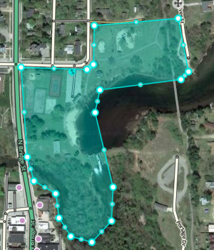
Moving an Area Place
To move an area place without changing its shape, click on the place to select it. Then, click and drag the move handle icon ![]() .
.
Place details
Every Place, whether Point or Area, should have as much detail completed as possible. This includes a name, proper categorization, and full street address, city, and state. If any Place does not have a City or Street, check the None checkbox.
General tab
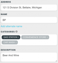
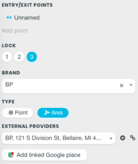
The General tab for a Place is where you complete all of the basic information: categories, name, description, gas brand, residential/public, country, state, city, street and house number.
Places considered fundamental to the functioning of the Waze app, such as gas stations, should be locked at least to rank 2 to prevent possible loss of data due to automatic acceptance of submissions from trusted users. Other complex, intricate, or crucial Places such as Police Stations, Fire Departments, Airports, Parks, etc., should also be considered for locking to prevent loss of data.
| Do not use the description field for notes to other editors. This field is visible in the Waze app and should only contain details pertinent to the place itself. |
The content of the general tab is dynamic to the category selected. Here is an example of a gas station area with its details completed:
Categories
Choose only categories that closely match the destination! If no subcategory provides a very close match, do not select a subcategory that "comes close". Instead, select a relevant umbrella supercategory or the Other category.
This approach may seem counterintuitive from an editing perspective. This is because editors begin with the Place and search for the category. Drivers, however, will begin with the category and search for the Place.
For example, consider a Wazer who needs to refuel a vehicle or tank with compressed natural gas (CNG). Categories that come close are Gas Station and Hardware Store. As an editor, one might assign Gas Station to a CNG fueling location as this seems to come the closest; but this would be a mistake. Car Services, Shopping / Services, or just Other would be more correct. Why?
A Wazer needing a CNG refueling site is highly unlikely to search for it under Gas Station, and if such a search were attempted, irrelevant results would outnumber useful ones by a vast margin. The Wazer will quickly realize that a text search for "CNG" will be more productive. Categorizing the location as a Gas Station would have provided no benefit to the Wazer. Meanwhile, Wazers searching for a gasoline refueling location would be offered CNG destinations, and worse, they may not realize this until they arrive at the CNG fueling site and discover it does not sell gasoline.
Thus, when choosing categories for a Place, do not ask "what category comes closest?" but rather "if a Wazer explicitly asks for this category, will this Place be representative of what they seek?" It is absolutely correct to use the Other category if nothing else available satisfies this question.
External providers
 |
 |
Waze allows you to connect places and POI from external providers. One of the providers is Google Maps. When a place is linked, drivers can select any destination from search results in the app, whether the result is from Waze or Google, it will always lead you to the navigation stop point from Waze. This can also be linked to a street address point for the business if the address point exists in Google Maps.
Connect an external POI following this procedure:
- Create or select a place.
- Click on the link: Add linked Google place.
- Gradually as you type the name of the place in the drop-down list, recommended external POI names begin to appear. (Note: if the name is shorter than three characters (e.g. BP), you will need to type a space after it.)
- Select the correct name.
- Save your changes.
If the place has already been linked, you will see a box with the name and address of the external POI.
If you find that a site is linked to an improper external POI:
- Delete link by clicking the X next to the POI field.
- Save the changes.
Do not link the same external provider link to multiple places, as only the last linked place will get the redirect.
Creating and editing links to external provider POIs is allowed only by Rank 2 editors and above.
Problems with external provider places
Some external provider search results cannot be linked to Waze places, either because they cannot be found in the external provider search tool, or because they cause save errors when linked. In addition, instant navigation using Waze's automatic speech recognition only returns results from Google Maps and navigates users to their centers. If addition of real drivable roads can't get users a correct route to a problematic external search result, a routable pedestrian path may be used. Due to its appearance, this is a fix of last resort for serious routing issues caused by external places.
More Info tab
In the More Info tab is additional helpful information for the Place. Here you will add phone number, website, additional services, and hours of operation:

Services
Services help users decide if they should drive to a particular place. Here are descriptions of available services. Waze uses the same set of services for every place type. The service checkbox only has two states, 'yes' or 'no answered', thus there is no way to determine if a place either does not have a service or an editor hasn't added one yet.
Website The place has a website that users can navigate to for information related to the business or government agency. When adding a website, also known as a URL, it is necessary to only add the primary domain information. These are acceptable examples of a website, or URL, that can be added: https://www.ontheborder.com, http://www.ontheborder.com/, www.ontheborder.com, and ontheborder.com.
Valet service The place has valet parking whereby drivers can valet their car, leaving it with an attendant who will park it for them. These services could be free or fee-based.
Drive-through The place has a drive-through window, which serves food or other items via a window that allows the driver not to leave their vehicle. Restaurants, banks, and pharmacies often have drive-through windows.
Wi-Fi The place has free Wi-Fi available for customers. Wi-Fi can be completely open, or accessible with a password that the place operator supplies the user.
Restrooms The place has restrooms available for customers to use.
Accepts credit cards The place accepts any type of credit card for payment of goods or services. At this time Waze does not differentiate between credit card types.
Reservations The place accepts reservations, i.e. a reserved time for dining in the place.
Outdoor seating The place allows diners to eat outside, weather permitting. Outdoor seating may be on the curb, sidewalk, or in a fenced in area on the premises.
Air conditioning The place has air conditioning, to cool and dehydrate the air when the ambient temperature considered to be warm or hot. This may be possible to infer by looking for air conditioning condensers or chillers on roofs or near buildings on aerial photography within the Waze Map Editor.
Parking for customers The place has parking for customers where they can leave their car, which could be free or for a fee, where the customer parks their own car and walks to the place.
Deliveries At this time this service is unclear. It could mean that the place either accepts deliveries, e.g. from UPS or FedEx, or makes deliveries of food or products to the customer, within a certain range.
Opening hours
The Opening hours section allows the editor to add or delete the hours of operation for Places, including unique times for each day of the week. The hours submitted in the editor may not overlap, or a save error will occur.
Photos tab

Any photos which drivers have added to a Place will appear in the Photos tab. In WME, we can review photos and delete (or merge from another Waze place (AP or PP). Photos can only be uploaded from the Waze app. Click on a picture to view a larger version.
Deleting a Place photo
Take great care to make a well thought-out decision to delete a photo. Once a photo is deleted, it cannot be recovered. Delete only if the photo really is unclear, not helpful and/or inappropriate.

Any improper or inappropriate photos should be removed. Hover the mouse over a picture in the Place Photos tab, and click the X which appears at the top right of the photo.
Place updates (moderation)
![]()
![]()
![]() The Place Update Request (PUR) marker shown to the left identify the location of a pending Place update, similar to an update request. The Place updates issue layer must be enabled to see these pending update request(s). When an untrusted driver submits a new Place or an update to an existing Place, these go into a moderation status.
The Place Update Request (PUR) marker shown to the left identify the location of a pending Place update, similar to an update request. The Place updates issue layer must be enabled to see these pending update request(s). When an untrusted driver submits a new Place or an update to an existing Place, these go into a moderation status.

- The Place update request markers will only appear if you have the "Place updates" layer enabled.
- Point Places with pending updates will display with the
 icon even when the "Place updates" layer is disabled.
 - With the Place updates layer enabled, an Area Place will display with an update request marker at its center.

When you click on the Place update request marker, you will be presented with a panel which details the updates the Wazer has submitted. The exact content of the panel will differ depending on the type and amount of information input by the end user using the Waze app.
- When you click on any Place which has a pending update, the following message will appear in the left tabs area of the editor screen. Clicking on it will display the update details just the same as clicking on the Place update marker.


Accept or reject?
The job of the Waze editor is to accept or reject Place updates sent by users from the Waze app. The general guideline to use to determine whether to Accept the update is:
"Is the majority of information provided in the update correct?"
A Place update, if the user completes ALL the information, can be extremely long (expand thumbnail to the right).
Even if some of the data is incorrect, or the photo included in the update improper and unhelpful to drivers, the editor can still remove the photo or update/delete the incorrect information after accepting the update. It is better, faster, and more honest to accept the good information from the driver, and fix the problems, rather than rejecting the entire update and filling in the info yourself.
Determining acceptable photos
Defining exactly what is an acceptable photo is difficult because of the huge variation in destinations. In general terms, the pictures of Places should be such that a driver could use the picture to help determine exactly which destination is the correct one. The system will try to show the arriving user the most relevant photo from their direction of arrival, time of day, etc.
Take great care to make a well thought-out decision to delete a photo. Once a photo is deleted, it cannot be recovered. Delete only if the photo really is unclear, not helpful and/or inappropriate.
The following are meant as guidelines both for the editor and for users taking pictures. Photos should:
- Show the exterior of the Place
- Be clear (not blurry, through rain-covered/dirty windows, not from moving vehicles/trains, etc)
- Be well lit
- Help differentiate the Place location from nearby Places
Photos could include images of, but not necessarily limited to:
- Door of store
- Front of Place with signage
- An image of the front/side of Place (angled) to exemplify the correct building
- Streetside signage of the Place
- Daylight images
- Night or evening images, as long as the image is clear and helps the driver identify the Place
Photos should not show:
- People's faces - any photo with a fully identifiable face should be removed, or not approved
- Car license plates - any photo with a fully identifiable license plate should be removed, or not approved
- Anything which allows a viewer to tie a person to a specific location
- Any pornographic content, nudity, sexual content or simulation, etc.
Examples of good and bad Place photos
Duplicate Places
When a user submits an update for a Place, but does not, or cannot, choose an existing Place in the app, it will show in the Waze Map Editor as a New Place. It could also happen that two users report a new Place at the same moment which results in two New Places.
The Merge Places feature will help with combining the duplicate places into a single place.
When you find a Place update which would duplicate an existing Place, or two New Place updates which are for the same place, if
- The Place update contains more than just a photo, and
- The Place update provides useful, updated information
Please follow these steps:
- Accept the update
- Save
- Use the Merge feature to combine the new place details into the original place
- The new place accepted from Step 1 will be deleted
If the criteria cannot be met, then Reject the Place update.
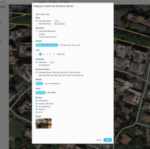
Merge Places
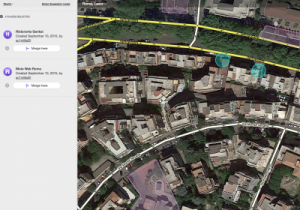
The Merge places feature is a great way to reduce errors when copying information over from one place to another.
You are able to merge two or more venues into a single venue.
Only Public Places can be merged; Residential Place Points cannot be merged. You cannot perform a place merge if any of the selected places are locked above your rank or you are not a trusted user
Details that can be merged from places:
- Name (Able to keep both names by setting one as Primary and the other as Alternate when merging)
- Description
- Address
- Lock Level
- Category
- External Provider
- Website
- Phone
- Services
- Pictures
To merge places together, use the following steps:
- Select the venues to merge by holding Ctrl and Click the venues (CMD and Click on Mac)
- In the sidebar of the window, you will see the venue information. Select the Merge button for the venue you wish merge the data into
- A window will appear to select which information you want to merge
- Click Merge
- Click Save to save your changes to the map
NOTE: Area Place geometry can't merge into a Point Place. If you need to merge a Point Place and an Area Place and want to keep the area polygon of the Area Place, then merge the Point Place into the Area Place to keep from having to recreate the area polygon.
Place update FAQs
Who can moderate places?
Users with Level 2 and higher can moderate within their editing areas.
What requires moderation?
- For new places: every new place which is created by an untrusted level 1 editor requires an approval by an editor ranked 2 or greater.
- For place updates: every update which is done for a place which is locked above the user’s rank will require a moderation by a sufficiently ranked user.
- Flagged (Reported Problem): all flags (for potentially problematic images or places) need to be moderated by an editor ranked 2 or greater.
What is a trusted user?
Once a certain number of contributions by the same user (from the client app or rank 1 editors) have been reviewed positively by a moderator, we consider that user trusted. They can now add new places directly without any moderation. Updates to existing places would still require moderator approval if the place is locked at a level above the editor's rank. (Ex Place locked to L3 generates a PUR for editors L1 or L2 even if a trusted user.)
What kind of places should we approve?
Almost anything which represents a real place should probably be approved. If a Waze user would ever make benefit from knowing that this place exists, it’s worth it. Exceptions are places which include private user information, inappropriate content, or otherwise irrelevant.
If at least some of the details of a place are correct, you are encouraged to approve it and then edit it accordingly.
What kind of photos should we approve?
Any photo which helps the user understand what this place is like is great. Outside pictures are even better, and we have a system that will try to show the arriving user the most relevant photo from his direction of arrival, time of day, etc. Inappropriate pictures or pictures which are not related to the place should be rejected.
Please remember - rejecting both places and photos will prevent the reporting user from getting points and might even get them blocked.
Can I partially reject an update?
Currently not. If a suggestion is only partially correct, it is recommended to approve it, save, and then edit the place to correct the wrong information or Merge the new information with an already existing place if it is a duplicate.
Can I move a photo from one Place to another?
Yes, you can utilize the Merge Places feature.
Can I move or merge any data from a duplicate Place update to an existing Place?
Yes, you can utilize the Merge Places feature.
Can a user become blocked from adding new places?
Every user (trusted or not) can become blacklisted and banned from adding places once they have tried adding a certain amount of places or updates which have been rejected. We also track places that have been flagged and removed - if we see a pattern where a certain user created many of these, they might be blacklisted. If this happens, the editor will no longer be able to add or edit places, or submit changes for places. When saving, the UI may say to try again. If this happens, contact your RC to find out why you may have been blocked.
Who gets the points for the new places created after an approval?
Users do not get points for pending places and updates until a moderator approves the suggestion. The moderator receives an edit point for either a rejection or an approval.
Do we get points for creating places from the client?
We grant the exact same number of points for the same edit whether it’s done from the client or the web editor.
Advertisers
If you find incorrect advertisement pins in the app for the location, name, or other details, they must be fixed by Waze staff. As of 2017[update], you have three options;
- If the advertisement is associated with a locked Waze Place, make the adjustments to the place in WME (this will become a PUR regardless of your rank), and the Waze staff team will review it.
- If the advertisement is not associated with a locked Waze Place, submit the Misplaced ad pins form. The Waze team monitors this so they can fix it or report it to advertisers.
- If neither of the previous options resolve the issue in a reasonable amount of time, contact a Champ or your Regional Coordinator who can contact staff directly.
What is the Residential setting? Private and public places
Our main goal in this project is to improve the data our users can get about public places. Since adding places is fun and can be even somewhat addictive, we figured our users might want to add private places (their home, for instance) as well. We want to provide an outlet for that so we can avoid having private places wrongly listed as public.
Residential Point Places (RPPs) or Private Places are searchable by address. Any name given ex "Mom's house" is not searchable and is removed when the RPP is approved. 1. RPPs are searchable by address only 2. The identity of the creator and any modifications made are shown in history 3. The identity of the photo addition is shown in history
The different attributes of a place
Most place attributes are quite self-explanatory. However, here are some points to consider:
Categories
We chose about 120 categories based on what Waze users currently search for. We aimed to have them as wide as possible, and we understand there might be a lot of places without an exactly suitable category. For these places, please use the categories that could contain the category they’re in.
Private / public
Public places can be turned into private places, but private places cannot be turned into public places. Use this to convert places mistakenly labeled as public into private. Private places only contain photos and an exact address, without all the other properties of a place.
Area-Point combinations

There are some situations where it will be appropriate to mix both Area and Point Places. For example, shopping centers and shopping malls where the mall itself could be considered a navigation destination, but there are also individual stores which are also valid for being marked.
A simple shopping center, when mapped in this manner, would look like this first image:
Combination naming
When naming Point Places which are contained within an Area Place in this way, it may be desirable to include the Area's name in the separate Point Place names. If this is desirable, name the Point Places with the specific name first, followed by a hyphen, followed by the Area name, as such:
- Point Specific Name - Area General Name
For example, Yulman Stadium - Tulane University or Apple Store - Lakeside Shopping Center. There are two exceptions: airports and emergency rooms.
Multiple categories
- A Place can be assigned to multiple categories
- The Primary Category for a Place must be the first one you enter
- The Primary Category is displayed in a darker shade of blue than the others
- The Primary Category is used to determine whether to use a Point or Area for the Place
When to use Area or Point
Here is the global guidance on selecting Area or Point for Places in the Waze Map Editor. This list is based on the US English language preference selection for WME. The default WME setting for standard English is slightly different for some entries.
The Primary Category for a Place is used to determine whether to use a Point or Area.
| Parent | Category | Type | Comments |
|---|---|---|---|
| Car Services | Car Wash | Point | |
| Car Services | EV Charging Station | Point | See the Places/Charging station page for more information. In addition to adding a charging station point Place, also add the 'Charging Station' service to the appropriate parking lot area (PLA) Place. |
| Car Services | Garage / Auto Shop | Point | |
| Car Services | Gas station | Area | Many gas stations also have convenience stores and ATMs. Remember to use "gas station" as the primary category and the add any others which are relevant. Please see the Places/Gas station article. |
| Transportation | Airport | Area | Special-handling |
| Transportation | Bridge | Area | Use only to represent a named road bridge with local or navigational significance. This should be an official/locally-used name, preferably signed at each approach. Do not use for unnamed bridges signed only for the feature they cross. Bridge areas are normally not used if road segments crossing a bridge use the bridge's name. Non-road bridges (e.g. railroad, pedestrian, aqueduct) are normally not mapped. |
| Transportation | Bus Station | Point | |
| Transportation | Carpool Spot | -- | Do not use. As of November 2018[update] this category is being tested by staff. |
| Transportation | Ferry Pier | Point | |
| Transportation | Junction / Interchange | Area | |
| Transportation | Rest Area | Area | Full guidelines for mapping are found on the Rest areas page. |
| Transportation | Seaport / Marina / Harbor | Area | Size-dependent. |
| Transportation | Subway Station | Point | |
| Transportation | Taxi Station | Point | |
| Transportation | Train Station | Point | |
| Transportation | Tunnel | Area | |
| Professional and Public | Cemetery | Area | |
| Professional and Public | City Hall | Point | |
| Professional and Public | College / University | Area | |
| Professional and Public | Conventions / Event Center | Area | Size-dependent |
| Professional and Public | Courthouse | Point | |
| Professional and Public | Doctor / Clinic | Point | Clinics, and Medical offices which do not offer urgent medical care for Walk-Ins should use the Doctor / Clinic, (and any other appropriate) category instead. See the Hospital wiki page for more details. |
| Professional and Public | Embassy / Consulate | Area | |
| Professional and Public | Emergency Shelter | ||
| Professional and Public | Factory / Industrial | Point | May be Area if Landmark |
| Professional and Public | Fire Department | Area | ONLY Fire Stations providing first response to nearby emergencies should use this category. All others should use a different category, such as Office. Administrative, training, and support facilities are not emergency locations. |
| Professional and Public | Government | Point | |
| Professional and Public | Hospital / Urgent Care | Area | ONLY Hospitals, Emergency Rooms, and places offering Urgent Medical Care should use this category. ERs encompassed in a hospital Place Area should be Points. |
| Professional and Public | Information Point | Point | |
| Professional and Public | Jail / Prison / Correctional Facility | Area | |
| Professional and Public | Landfill / Recycling Facility | Point | |
| Professional and Public | Library | Point | |
| Professional and Public | Military | Area | |
| Professional and Public | Offices | Point | May be Area if Landmark |
| Professional and Public | Organization / Association | Point | |
| Professional and Public | Police Station | Area | |
| Professional and Public | Post Office | Point | Category only for Post Offices, Village Post Offices, and Contract Postal Units as defined by the USPS.
When searching for "post office" in the Waze app, the quick search results will only display places that begin with "Post Office" in the primary name. If pushed to a full search, will only display places that have the "Post Office" category. See the Post Office page for more details. |
| Professional and Public | Preschool / Daycare | Point | |
| Professional and Public | Religious Center | Point | |
| Professional and Public | School | Area | |
| Shopping / Services | Arts & Crafts | Point | |
| Shopping / Services | ATM | Point | |
| Shopping / Services | Bank / Financial | Point | |
| Shopping / Services | Bookstore | Point | |
| Shopping / Services | Car Dealership | Point | Size-dependent |
| Shopping / Services | Car Rental | Point | |
| Shopping / Services | Cell Phones | Point | |
| Shopping / Services | Clothing / Fashion | Point | |
| Shopping / Services | Convenience Store | Point | |
| Shopping / Services | Currency Exchange | Point | |
| Shopping / Services | Department Store | Point | |
| Shopping / Services | Electronics | Point | |
| Shopping / Services | Florist | Point | |
| Shopping / Services | Gift Shop | Point | |
| Shopping / Services | Gym / Fitness | Point | |
| Shopping / Services | Hardware Store | Point | |
| Shopping / Services | Home Furnishing | Point | |
| Shopping / Services | Jewelry | Point | |
| Shopping / Services | Laundromat / Dry Cleaner | Point | |
| Shopping / Services | Market | Point | |
| Shopping / Services | Music Store | Point | |
| Shopping / Services | Personal Care | Point | |
| Shopping / Services | Pet Store / Veterinarian Services | Point | |
| Shopping / Services | Pharmacy | Point | |
| Shopping / Services | Photography | Point | |
| Shopping / Services | Shopping Center | Area | |
| Shopping / Services | Sporting Goods | Point | |
| Shopping / Services | Supermarket / Grocery | Point | |
| Shopping / Services | Swimming Pool | Point | |
| Shopping / Services | Toy Store | Point | |
| Shopping / Services | Travel Agency | Point | |
| Food and Drink | Bakery | Point | |
| Food and Drink | Bar / Winery / Tasting Room | Point | |
| Food and Drink | Coffee Shop | Point | |
| Food and Drink | Dessert | Point | |
| Food and Drink | Fast Food | Point | |
| Food and Drink | Food Court | Point | |
| Food and Drink | Ice Cream | Point | |
| Food and Drink | Restaurant | Point | |
| Culture / Entertainment | Art Gallery | Point | |
| Culture / Entertainment | Casino | Area | Large hotel-casinos perhaps could be Area Places. |
| Culture / Entertainment | Club | Point | |
| Culture / Entertainment | Game Club | Point | |
| Culture / Entertainment | Movie Theater | Point | |
| Culture / Entertainment | Museum | Point | |
| Culture / Entertainment | Music Venue | Point | |
| Culture / Entertainment | Performing Arts Venue | Point | |
| Culture / Entertainment | Race Track | Area | |
| Culture / Entertainment | Stadium / Arena | Area | |
| Culture / Entertainment | Theme Park | Area | |
| Culture / Entertainment | Theater | Point | |
| Culture / Entertainment | Tourist Attraction / Historic Site | Point | May be Area if Landmark |
| Culture / Entertainment | Zoo / Aquarium | Area | Size-dependent |
| Other | Construction Site | Area | Not necessary to be mapped. |
| Lodging | Bed & Breakfast | Point | |
| Lodging | Campground / RV Park | Both | These locations serve overnight or week-long guests and the area should cover all campsite/RV roads inside of the toll gate/payment booth on the entrance road (primary/main if multiple entrances). The navigation stop point should be placed on the primary entrance toll gate/payment booth. Trailer Parks and Mobile Home Parks (serving mainly long term residents over months or years at a time) should be treated as townhome complexes or apartments/condominiums and use the Residential Point Place as needed. |
| Lodging | Cottage / Cabin | Point | |
| Lodging | Hostel | Point | |
| Lodging | Hotel | Point | |
| Outdoors | Beach | Area | |
| Outdoors | Golf Course | Area | |
| Outdoors | Park | Area | |
| Outdoors | Playground | Point | |
| Outdoors | Plaza | Point | |
| Outdoors | Pool | Point | |
| Outdoors | Promenade | Point | Unsure about mapping these at all |
| Outdoors | Scenic Lookout / Viewpoint | Point | |
| Outdoors | Ski Area | Area | |
| Outdoors | Sports Court | Point | |
| Natural Feature | Canal | Area | |
| Natural Feature | Dam | Area | |
| Natural Feature | Farm | Point | |
| Natural Feature | Forest / Grove | Area | Only map official state/national forests, not every stand of trees. |
| Natural Feature | Island | Area | |
| Natural Feature | River / Stream | Area | Use only if water itself is visually obvious to drivers on nearby roads. Do not remap features already present in the built-in Waze water layer unless that layer is incomplete or inaccurate. Map only the typical extent of visible water, not adjacent open space, greenbelt, culvert, meadows, or flood plain. If the river/stream is too narrow to map conveniently with an Area Place, it should not be mapped at all. |
| Natural Feature | Sea / Lake / Pond | Area | Use only if water itself is visually obvious to drivers on nearby roads. Do not remap features already present in the built-in Waze water layer unless that layer is incomplete or inaccurate. Map only the typical extent of visible water, not adjacent beaches or land. If the feature is too small to map conveniently with an Area Place, it should not be mapped at all. |
| Natural Feature | Swamp / Marsh | Area |
Landmarks
Any Place that functions as a landmark may be represented as an Area Place even if the table above indicates otherwise. A landmark Place is defined as a named, architecturally unique location, locally well known for its uncommon height or iconic exterior appearance, easily visible to and recognizable by passing drivers, that is visually and obviously unlike its immediate surroundings. Horizontal size alone, such as found in vast but nondescript office building complexes, does not qualify a location as a landmark. Nor does fame due to whatever goes on at or inside the location, especially if its exterior is unremarkable or poorly visible to passing drivers.
Landmarks are not to be confused with local references. A local reference is a location used for orientation by those who frequently pass near it. Every landmark is a local reference, but not every local reference is a landmark. For example, the Golden Gate Bridge is a landmark, while an ordinary tire shop with a big, brightly colored sign is a local reference.
Any location may be mapped as an Area Place if the table above allows it for its category, regardless of whether it qualifies as a landmark.
When creating an Area Place for a landmark, assign its primary category to reflect what makes it a landmark. This primary category may have little or nothing to do with the location's owner, operator, or tenants. For example, the Empire State Building is a landmark that also provides space for offices; the primary category of its Area Place is "Tourist Attraction / Historic Site" since that is what makes it a landmark, while its secondary category of "Offices" notes the offices within it. Another example is a small but uncommonly historic and visually distinctive retail building with several destination stores; the building would receive a "Tourist Attraction / Historic Site" Area Place, while the stores would receive Point Places within the building.
Retailers
Some retailers have built dedicated stores with such uncommon exterior design that they are unquestionably landmarks by the definition above. Marking such stores with Area Places may, however, puzzle unfamiliar drivers who will simply see the name of the retailer on their map. They may not understand its significance as a landmark and indeed may confuse the Area Place on their display with an advertisement. As of February 2015[update], it is not encouraged to map any structures built by and dedicated to single retailers as Area Places, regardless of how visually iconic.
Place Name Harmonization
The primary purpose of Place Name Harmonization (PNH) is to provide a consistent and optimal user search experience in the app. The goal is to maximize the likelihood that a user will be able to quickly find what they are searching for, first in Instant results, then in full search. When a business name is harmonized a standard (State, Region or National) is made for the primary name, alternative names if appropriate, descriptions, website link and other details as necessary.
A minimum of 5-10 locations is usually preferred before a business is harmonized. If a business is expected to grow beyond this number then early submission makes sense.
The PNH process starts with map editors submitting a request for harmonization of a business. This submission is reviewed by regional moderators and can be made national if appropriate. Due to complexities of how businesses may operate in different regions, occasionally a businesses may have different nuances in each region. If you have a question about a business please feel free to contact your regional PNH moderator listed below.
The WME Place Harmonizer (WMEPH) script is available to help editors choose the harmonized name for businesses, as well as to help fill and format other place fields.
Great Lakes Region (GLR - IL|IN|MI|OH|WI)
View GLR list full-screen in Google Sheets
Hawaii Region (HI)
View HI list full-screen in Google Sheets
Mid Atlantic Region (MAR - DC|MD|VA|WV)
View MAR list full-screen in Google Sheets
New England Region (NER - CT|MA|ME|NH|RI|VT)
View NER list full-screen in Google Sheets
Northeast Region (NOR - DE|NJ|NY|PA)
View NOR list full-screen in Google Sheets
NorthWest Region (NWR - AK|ID|MT|OR|WA|WY)
View NWR list full-screen in Google Sheets
Plains Region (PLN - IA|KS|MN|MO|NE|ND|SD)
View PLN list full-screen in Google Sheets
South Atlantic Region (SAT - KY|NC|SC|TN)
View SAT list full-screen in Google Sheets
South Central Region (SCR - AR|LA|MS|OK|TX)
View SCR list full-screen in Google Sheets
Southeast Region (SER - FL|AL|GA)
View SER list full-screen in Google Sheets
Southwest Region (SWR - AZ|CA|CO|NM|NV|UT)
View SWR list full-screen in Google Sheets
Territories Region (ATR - AS|GU|MP|PR|VI)
Detailed guidance for select categories
The following categories have detailed guidance for how to set them up and organize the data in these places.
Moving
If a point place is moved more than 1046.59 feet (319 meters), the change cannot be saved in WME. Therefore, if a business or other public place has moved a short distance, move the associated point place to the correct location, update the address and delete any photos that are no longer accurate. However, if a business has moved a long distance, remove the place as permanently closed according to the following section and create a new place.
Closed
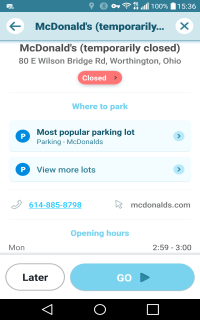
There are various reasons that a place may not be open for normal business in the long term:
- It may be permanently closed or moved away.
- It may be under long-term renovation or equipment overhaul, as is sometimes the case with shopping malls, hotels and gas stations.
- It may still be under construction but already well known, as is the case with some large destination stores and attractions.
Whatever the reason, Waze users should not be routed without warning to places that are not open for normal business. However, because Waze includes third-party results in searches for places, without a linked Waze place, users may end up navigating to a third-party result with no way of knowing that the place is not open or does not even exist. In the United States, the only external provider of Waze search results is Google Maps, and places that are marked permanently closed in Google Maps do not appear in Waze search. Therefore, after confirming that a place is not open for business due to any of the above reasons, the following procedures should be used:
| General Process Steps | Specific Process Steps | ||||
|---|---|---|---|---|---|
| Permanently Closed | Temporarily Closed | Under Construction | |||
| 1 | Select the place in WME, or create it if it exists only in Google Maps and is open, that is, not marked permanently closed. | ||||
| 2 | Check each existing external provider link in Google Maps to see whether it is open or permanently closed. | ||||
| 3 | Search the general area in Google Maps to find other relevant places that are listed as open. | ||||
| 4 | In WME click "Add linked Google place" to search for each relevant, open Google place, and create links to them (the minimum rank to add linked Google places is 2). | ||||
| 5 | If your place is linked to | no open Google places: | Delete the place and stop. | Continue to the next step. | |
| open Google places: | Continue to the next step. | ||||
| 6 | Add at the end of the name | if open date known: | (permanently closed) | (reopens [date]) | (opens [date]) |
| if open date unknown: | (temporarily closed) | (under construction) | |||
| 7 | Add a note in the description | if open date known: | Reported closed [date] | Reported closed [date], reopens [date] | Opens [date] |
| if open date unknown: | Reported closed [date] | Coming soon | |||
| 8 | Reduce open hours | to one minute per week at a time least likely to be viewed, such as 02:59-03:00, Monday morning. | |||
| 9 | Reduce visibility | Change all categories to Other; if a Parking Lot, uncheck "Accessible parking" before this change. If an area place, change to point (remember to do a trigger edit nearby). | |||
| 10 | Submit third-party correction and/or wait. | Submit a correction in Google Maps to mark each place permanently closed. | Wait until reopening. | Wait until opening. | |
| 11 | Final cleanup. | Delete the Waze place after each linked Google place is marked permanently closed. | Change the Waze place back to normal after reopening. | Change the Waze place to normal after opening. | |
Flagging
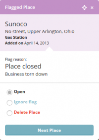
Waze users will frequently flag closed places for deletion, which generates a PUR with the options of ignoring the flag or deleting the place. If the place should be deleted immediately, delete it through the flag, which will send the user a message that the flag was reviewed and approved. If you need to wait to delete the place until third-party results are corrected, wait to handle the flag and then delete the place through the flag. If the place is still open or has just moved a short distance, hit "ignore" on the flag PUR.
Additional information
Closed advertised places may require the help of a state manager or regional coordinator for removal from Waze.


