WV Closure Tracking
Below you will find the google form and the google sheet currently being used to track closures in West Virginia. The form is for use by anyone and feeds information the sheet. The sheet is used by those that can implement the closures.
The WME Form Filler Script is a Form Filler Script that saves a lot of time for the people adding closures to the sheet. You will need tampermonkey in order to install the script. This script serves many purposes, including the USA VEOC, so be sure to choose "WV closures" from the pulldown to feed the correct sheet.
Please populate the sheet via either the form or the form filler script to be sure all of the automated features of the sheet work properly.
WV Closure Sheet informatioɲ
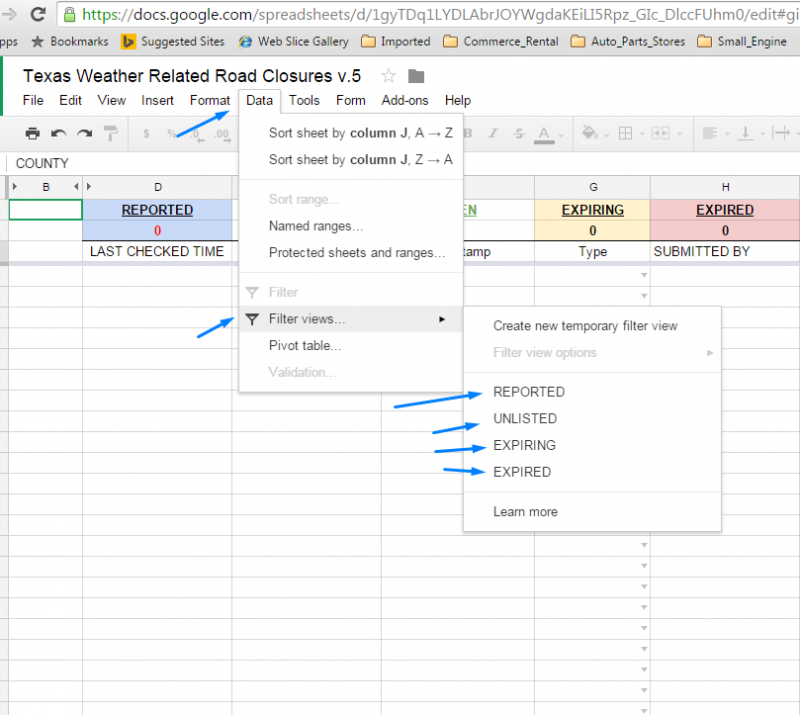
To change the view and only see a certain condition Click on (Data) then (Filter views) then choose the one you want from the choices on the far right.

COLUMN C
This is the Permalink to the closure with the layers stripped out.
UPDATING TIME CHECKED
Updating the time checked in Column G "LAST CHECKED TIME" is as simple as changing the name (Has to be a name change) in Column H "LAST CHECKED BY" or typing something in Column E (ie I usually just type the number 1). It should automatically update to the current time.
COLUMNS A-E
Are not editable as they are derived data. If the closure date/time needs extended please edit the date/time in Column T
Further information is Available in the Wazeo Tab of WV Closure Sheet
WME Suggestions
Do not make any edits to a segment that will force a change of the segment id. If the segment id changes you will need to wait for a tile update before you can add a closure to the segment. For extremely long sections of segments please provide the beginning and ending segments. The editor doing the closure will fill in the between segments. Zoom Levels... When creating a PL for a closure please be sure you are zoomed to at least Level 4 [100 M | 500 Ft]
Finding closure locations
The WV Counties Overlay script that will show the boundaries and the county name. This is very important to use so that you can verify you are closing the correct road segment in the correct county. Some road names are used in more than one county.
The WV geometry and measures site helps to locate any road given the county and route numbers using the search at the lower left to build a route ID, including finding mileposts if that information is available.
Sources For Road Closures
WV DOT Work Zones
- District 1 [Boone, Clay, Kanawha, Mason, Putnam]
- District 2 [Cabell, Lincoln, Logan, Mingo, Wayne]
- District 3 [Calhoun, Jackson, Pleasants, Ritchie, Roane, Wirt, Wood]
- District 4 [Doddridge, Harrison, Marion, Monongalia, Preston, Taylor]
- District 5 [Berkeley, Grant, Hampshire, Hardy, Jefferson, Mineral, Morgan]
- District 6 [Brooke, Hancock, Marshall, Ohio, Tyler, Wetzel]
- District 7 [Barbour, Braxton,, Gilmer, Lewis, Upshur, Webster]
- District 8 [Pendleton, Pocahontas, Randolph, Tucker]
- District 9 [Fayette, Greenbrier, Monroe, Nicholas, Summers]
- District 10 [McDowell, Mercer, Raleigh, Wyoming]
City Engineers, Local TV, Newspapers, Radio, Twitter, Facebook, etc. (not an exhaustive list)