Symbian Keypad
Downloading the application on the device
Install the application on the device
The installation will start after downloading is finished.
1. Press Yes
2. Press Continue.
3. Select the type of memory (device/card) you want to install waze on. We recommend you install it on the device memory, for better performances.
4. Wait until the installation is complete.
5. After the initialization you'll be required to select your location (If the GPS and AGPS are turned off)
6. Read and confirm the license agreement.
7. Create a new account:
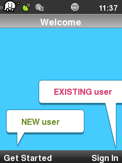
1. If you're a new user at waze, select New user.
2. Fill out the details below in order to create your account.
You'll be asked to provide a username and password, an email address, and optionally to choose a waze nickname, which is used to identify you on the map and in reports you send, should you choose to be identified.
- Select the username you'd like. The username is case dependent so Jenny is not the same as jenny.
- After you have proceeded to fill in all the form, waze will display the filled-in form (your password will be displayed as five stars no matter how long it actually is).
- If the information is the way you want it, select Create in order to create your account. If not, select the line you want to change.
3. Tap Next to confirm and to enter as a registered user or Skip if you don't want to register at this moment.
- Note that if you select “skip”, a temporary account will be created for you If you skip the registration.
- You will not be able to access waze's web site and points you get during driving will not be saved!.
Installing the application using Nokia PC Suite
Interactive guide to Nokia PC Suite
1. Download the installation file to your computer from the following link: LINK
Save it on your desktop (you can delete the file later).
2. Press Ok.
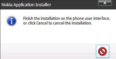
3. After this comment, the installation will continue on your phone.
Main screen
After registering, the following screen will appear:
Top status bar
GPS Connectivity - (green means connected , orange means partial coverage, gray is disconnected).
Connection Status- (gray means disconnected, when connected no icon appears).
![]()
Mood icons- (happy, sad, etc...)
![]()
The smiley shows the mood you're in at the moment. If you've chosen to be visible to other wazers (green privacy icon), your mood is also displayed to them; and if you've chosen to tweet your reports to your Twitter followers, they'll see your current mood as part of the tweet.
Groups
This icon refers to the number of reports received by the groups you’re registered to.
Reports on the road
This icon refers to the number of traffic reports and events received by the community
The main screen
You can select whether to present the map in 2D or 3D:
2D
3D
Clicking on 5 will switch to 3D view. (if you'll press it again it will switch back to 2D)
This state will be added to the map in another dimension - a dimension depth which will allow wider angle of vision.
Zoom
If you want to zoom-in on the map then press the * button.
If you want to zoom-out on the map then press the # button.
Text buttons on the bottom of the main screen:
- Me on Map (displays where you are right now).
- Menu
- Report (you will get this option when pressing me on map)
- Note - report options will appear only if there is GPS reception and network data connection.
Report
Clicking on  will open the next menu:
Note - all options will appear only if there is GPS reception and network data connection.
You can choose one of the following events:
Police![]()
Traffic jam![]()
Accident![]()
Hazard![]()
Speed cam![]()
Chit chat![]()
Map update![]()
Police
Clicking on the marker opens the following menu:
You need to choose if it's in your lane or opposite lane.
(If necessary, you can add a comment or a picture)
Traffic jam
Clicking on the marker opens the following menu:
You need to choose if it's in your lane or opposite lane.
(If necessary, you can add a comment or a picture)
Accident
Clicking on the marker opens the following menu:
You need to choose if it's in your lane or opposite lane.
(If necessary, you can add a comment or a picture)
Hazard
Clicking on the marker opens the following menu:
You need to choose if it's in your lane or opposite lane.
(If necessary, you can add a comment or a picture)
Speed cam 
Clicking on the marker opens the following:
Press Ok.
Map update 
Clicking on the marker opens the following menu:
Clicking on the icon ![]() will able you to record roads.
will able you to record roads.
To cancel recording, press the same icon again. ![]()
![]() Map error - Clicking this icon Will open the following window:
Map error - Clicking this icon Will open the following window:
Map problem categories are:
Incorrect turn - the map shows that you can make a turn at that point which in fact isn't allowed.
Incorrect address – the name of the street is incorrect
Incorrect route – the navigation instructions here are incorrect
Missing Roundabout
General Map Error - here you'll key in the details before you press Send.
After you press Send you get a message that the report was sent correctly.
 House number - Pressing on the icon it will enable you to update house numbers
Menu
Settings
The settings allow you to view and personalize your waze experience
To enter the settings menu click on menu (in the bottom left side of the screen)
you will get the following screen:
Then click on settings the following screen will appear:
You can choose one of the following events:
General
Profile
Map
Routing
Data Usage
Groups
Recommend
Help/Support
General
By clicking on General the following screen will appear:
Measurement system - you can choose to display distances in miles or in kilometers.
Volume Control - to choose the volume level for voice directions.
Auto zoom of maps (on/off) – by default it's "on", so the map will zoom in and out
while you're navigating, based on the distance to your next decision point(e.g. place where
you have to turn). You can disable this feature by selecting "off". Whether to display
the points ticker ("on" to display it, "off" to hide it)
Automatic night mode (on/off) – the default is "on": waze switches between day and
night mode automatically. To disable this automatic switching, choose "off". You
can still switch manually between day and night modes from the main Settings screen.
Backlighting (on/off): by default it's "on", and the backlight will remain on as long as
waze is on.
By clicking the Events Radius the following screen appears:
Profile
By clicking on profile in the settings menu the following screen appears:
It displays your account details: username, five stars representing your password
(no matter how long your password is) and nickname; and lets you change your nickname.
To change your username and password, first go to the waze.com site, log in, and make
the changes, and only then update it on your phone.
It displays a car icon which will represent your car on the map you see.
You can choose from a large number of cars of different types and colors
(more cars coming soon!!)
It displays the icon for your current mood – you can change it to one of the others.
Twitter – lets you choose whether to tweet your waze reports to your twitter followers;
if you choose to do so, enter your Twitter username and password. Your current mood will
be included in the tweet. You can disable and re-enable tweeting at any time without affecting
FourSquare - lets you set up your foursquare account to use with waze, and set tweets about
your foursquare activity.
Map
Here you can adjust which items will be shown on your map(speed cams, other wazers,
By clicking on (map) in the settings menu the following screen appears:
Color map scheme
Allows you to customize the appearance of your map
When pressing on Color map scheme option the following screen appears:
There you can choose your scheme.
Routing
Here you can tell waze how to calculate the optimal route for you. The options are:
In the Routing menu press on the option Route preference the following screen appears:
Dirt roads – you can choose to allow their inclusion in your route, to forbid it, or to
allow short ones but avoid long ones where possible. Dirt roads may be shortcuts,
but sometimes a driver doesn’t take into account the length of the dirt road.
In the Routing menu press on the option Dirt roads the following screen appears:
Data Usage
By clicking on (Data usage) in the settings menu the following screen appears:
When you are near a WIFI connection we advise you to perform a full map
download which will later reduce you data usage since the information downloaded
to your phone will update existing tiles, while data that hasn’t been changed
Groups
By clicking on (Groups) in the settings menu the following screen appears:
Pop-up reports
In the Groups menu press on the option Pop-up reports the following screen appears:
Wazers group icons
In the Groups menu press on the option Wazers group icons the following screen appears:
The menu will prompt you for three options.
My main group only - After choosing your main group you can define waze to show you
popups from that group only.
The groups I follow - Once Choosing this option the user will be prompted to
pop-ups from all of the groups that he’s registered to.
All groups - This option stops the screening of messages and pops up all of the
groups pop-ups from groups near the user.
Recommend
By clicking on (Recommend) in the settings menu you can recommend waze to one of
your friends.
After choosing this option the following screen appears:
Press Yes
Enter the phone number of your friend:
Press Ok
Drive to
In order to navigate you need to press on the Drive to option in the menu:
You will get the following screen:
Please note! The quickest way to navigate to the address is to keep it in favorites.
Address or Place
You may enter the name of a road, an address, a place name or keywords. Waze
is smart and will show you a list of matches in order based on the closest and
importance of the place.
After choosing the Address or Place option you will get the following screen:
My favorites
Add to favorites
Adding an address to favorites allows quick access to common addresses as defined by the
For adding an address to favorites you need to put the address in the Drive to search bar:
Press Ok.
Choose the option form the list:
After choosing the following screen appears:
Choose the Add to favorites option and write the favorite name.
Press Ok (it will be saved)
Select a favorite and navigate
Go to menu press on Drive to then press on My favorites:
Choose the preferred option from the list:
Recent searches
A list of recent locations you selected after using Search address or Place or
selecting a destination using the Location Menu. The most recent search is at
the top. Note that a place found by a search or by selecting a location on a map
will show as an address.
Destinations chosen from My favorites or Saved locations are not included in the Recent
searches list.
Press Menu and then Drive to
Press Recent searches
After selecting Recent searches, the following screen appears:
The addresses can be added to favorites by clicking options (far left side of the screen)
the following screen appears:
You need to select on the Add to favorite option.
Fill the name and press Yes:
Saved locations
A list of locations saved using the #Location Menu. You can select any location here as your
destination. The most recently saved location is at the top of the list of Saved locations.
To add an address to saved locations, press and hold the desired location on the map the
following screen will appear:
Then select Save location
The following screen will appear:
Press on Name.
And fill in the name.
Press Ok then save.
Then you will reach the following screen appears:
Press on the location you desire, the following screen appears:
On that screen you can select one of the options: Drive, Show on map, Delete, Add
to favorites.
If you want to select from Saved locations you need to do the following:
Press Menu and then Drive to
Press Saved locations
After selecting Saved locations, the following screen appears:
After selecting the preferred address name, press Options the following screen appears:
Delete Favorites / Saved locations
To delete an address, press on Menu and Then Drive to
Select My favorites/Saved locations
The following screen appears:
After selecting the preferred address name, press Options and then Delete
Then the following screen appears:
Press Yes.
Stop Navigation
Press Menu and then Stop navigation
Track details
Press Menu and then Navigation list.
After selecting Navigation list details of the chosen route:
Real-time information
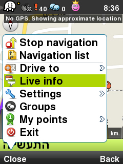
To view real-time information, press Menu and Then Live info.
The menu bar at the top of the screen shows a list of all the reports:
Attention
You can filter the list by police, traffic, accidents and etc with the left and right
arrows at the top of the screen.
Groups
To view the groups on the map, press Menu and Then Groups:
Attention
The device not supporting the Groups interface, this note will appear after selecting
Groups category.
My points
To watch the information on scoreboard and points ticker press Menu and then My points:
Then the following screen will appear:
For choosing scoreboard select Scoreboard and for points ticker select the option
Show points ticker:
Then the following screen will appear:


