Machete808 (talk | contribs) No edit summary |
m (add PL, remove httpS) |
||
| Line 11: | Line 11: | ||
But because many Wazers will search for a location by its postal address, U.S. management has established an editing standard to include the city designated by the U.S. Postal Service as an alternate on segments having no name, or a conflicting name, in the City field. | But because many Wazers will search for a location by its postal address, U.S. management has established an editing standard to include the city designated by the U.S. Postal Service as an alternate on segments having no name, or a conflicting name, in the City field. | ||
For example, these images show a discrepancy between Waze RPP and Google coordinates, and where the Waze app puts the search result. The example shown in the images is 10020 SW Grabhorn Rd, Beaverton, OR. | For example, these images show a discrepancy between Waze RPP and Google coordinates, and where the Waze app puts the search result. The example shown in the images is [http://www.waze.com/editor/?env=usa&lon=-122.88559&lat=45.44846&zoom=6&mode=0&venues=155386310.1553928641.3818499 10020 SW Grabhorn Rd, Beaverton, OR]. | ||
[[File:EditCityData.png|right|180px|Editing segment city data]] | [[File:EditCityData.png|right|180px|Editing segment city data]] | ||
| Line 25: | Line 25: | ||
Editors should use official USPS tools to check the city. If you know the ZIP Code, the city can be looked up here, or entering a city believed to be correct can be verified: | Editors should use official USPS tools to check the city. If you know the ZIP Code, the city can be looked up here, or entering a city believed to be correct can be verified: | ||
http://tools.usps.com/go/ZipLookupAction_input | |||
Every Door Direct Mail, a mapping tool from USPS, produces a map with ZIP Code boundaries: | Every Door Direct Mail, a mapping tool from USPS, produces a map with ZIP Code boundaries: | ||
http://eddm.usps.com/eddm/customer/routeSearch.action | |||
TIGERWeb is an online service of the U.S. Census Bureau: | TIGERWeb is an online service of the U.S. Census Bureau: | ||
http://tigerweb.geo.census.gov/tigerweb/ | |||
Revision as of 03:29, 14 November 2016
To keep city names from sprawling over too wide an area in the Waze app, in WME and LiveMap, editors follow standards of placing the city name on segment details only within the boundaries of the city polygon. That means many addresses on the map are in these “no city” areas, particularly in rural regions.
The search problem
An editor can create a Residential Point Place (RPP) in the correct location with an accurate address, but Waze may not route to the RPP if the city is not on a nearby segment. It will turn up under the "more results" tab in the app, but will be listed without a city and thus unlikely to be chosen.
Waze search defaults to best match of search terms, whether they're entered in search fully or selected from the autofill results. If the Wazer enters or selects a postal address and there is none on the Waze segment, Waze will go to its Google backup data that matches and will route to that pin. That’s not always optimal, especially in rural areas or other locations where the destination is some distance from the named road.

There are sometimes multiple city names in use for an area — a municipality or a Census Designated Place (CDP), in addition to the postal address.
But because many Wazers will search for a location by its postal address, U.S. management has established an editing standard to include the city designated by the U.S. Postal Service as an alternate on segments having no name, or a conflicting name, in the City field.
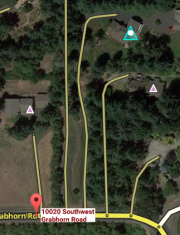
For example, these images show a discrepancy between Waze RPP and Google coordinates, and where the Waze app puts the search result. The example shown in the images is 10020 SW Grabhorn Rd, Beaverton, OR.

The city has now been added to the segment off the main road closest to the RPP. NOTE: In order to add an alternate city to an unnamed road segment, it’s necessary to put the street name of the address in the primary position, and then save, to get the option to add an alternate. The street name can be deleted from the primary after the alternate is in place.
The improved navigation result can be seen in the final screenshot from the app.
There are other standards in place for other purposes requiring adding other street data in the the alternate. The addition of the USPS data does not change any other standards but is in addition to anything existing already on those affected segments.
Identifying the correct postal city
Editors should use official USPS tools to check the city. If you know the ZIP Code, the city can be looked up here, or entering a city believed to be correct can be verified:
http://tools.usps.com/go/ZipLookupAction_input
Every Door Direct Mail, a mapping tool from USPS, produces a map with ZIP Code boundaries:
http://eddm.usps.com/eddm/customer/routeSearch.action
TIGERWeb is an online service of the U.S. Census Bureau: