No edit summary |
No edit summary |
||
| Line 70: | Line 70: | ||
=== City names === | === City names === | ||
Adding new cities to WME is restricted to L5 Country Managers, to prevent proliferation or alternate spelled city names. | ''Adding new cities to WME is restricted to L5 Country Managers, to prevent proliferation or alternate spelled city names.'' | ||
For cities and villages, we adhere to the standard UAE naming convention: | For cities and villages, we adhere to the standard UAE naming convention: | ||
Revision as of 11:33, 15 February 2017
Hello everyone!
We have an official Waze forum and a Waze UAE Facebook group.
The map of the Emirates attracts a lot of foreign editors, so this page is in English. We are looking for people who speak Arabic to help.
#Slack
Waze Map Editor Chat has no history or advanced possibilities of messages or sharing pictures. Waze Forum is a bit sluggish and if not very suitable for a quick chat between a couple of editors. Therefore we have setup a Slack Team for Waze UAE editors. We like all UAE editors to join there, so we can chat about edits, local road work, closures, street names, WME tips, scripts, etc, etc.
To enhance your editing experience and keep the UAE map up-to-date. We like to have ALL editors in the Emirates to join! You can sign up by filling this form. After that, you will receive an email from Slack, where you can enter email and create a password. You can use slack in a browser, a desktop app or on your mobile phone!
Editing the map
If you already have general editing experience, please continue reading here to learn about the things we do a little bit different in the United Arab Emirates compared to the rest of the world.
If you are completely new to editing, we recommend you first visit the Waze Map Editor (WME) Welcome page.
Of course you want to get to editing right away, but as a minimum you will want to visit the Map Editing Quick-start Guide, so you understand what features you have available in the WME and a simple explanation on how to use them.
For a more in depth understanding of Map editing, we recommend you read the Waze Map Editor page.
As a new editor, you are likely to make some mistakes in making changes to the map. This article will show you some of the more common editing errors, and how you can address them. (article to be adjusted for UAE)
| You may only use information obtained from Waze's Streetview and Satellite View, and from own observation to build/enhance the map. Use of other external sources is not allowed and would compromise the entire map. Failure to comply with this rule will result in your editing rights being revoked. |
When you think you understand enough of the basic concept of map editing, please continue reading below to learn about the UAE way of Map Editing!
Terminology
- PU: Place Update (suggested places or changes to place information)
- UR: User Report (User reports of map problems)
- MP: Map Problem (prompted reviews generated by Waze backend from suspected mapping issues)
- NYN: Near You Now (number of Wazers currently online in your metro area - not available everywhere yet)
Names in general
It's often not very clear what a road, village or place is called, so either leave it empty, or make a good guess and hope that local editors improve it.
You can find names on streetview by looking for signs.
English in names
English is the basic in all road and place names. The percentage of English speaking people in the UAE is higher then the percentage of Arabic speaking people. When Arabic is added to names, as a second language, the 2 languages shall be separated by a comma and space This assures the instructions given in Waze match what drivers are seeing to avoid confusion.
For the english part of names, use the abbreviations as listed here
State names
State name support is awaiting HQ activation. Once activated, the intent is for the name of the Emirate to go into this field: Abu Dhabi, Ajman, Dubai, Fujairah, Ras al-Khaimah, Sharjah, and Umm al-Quwain.
City names
Adding new cities to WME is restricted to L5 Country Managers, to prevent proliferation or alternate spelled city names.
For cities and villages, we adhere to the standard UAE naming convention: [English name], [Arabic name]
- [English name] is composed of [city] for main cities and small cities without districts.
- [English name] is composed of [[district], [city]] for districts within large cities such as Dubai, Abu Dhabi, etc.
[district] is based on public known name and/or road signs. [city] might be skipped if it's not adding any value to the district name. Again based on local knowlegde.
If no arabic name is known, do not guess or use any placeholder text; just write the English name.
Roads
Street names
We try to match street names to match local signage when official signs with romanization are available. This assures the instructions given in Waze match what drivers are seeing to avoid confusion that might lead to an accident or missed turn.
1. Road Names Sources:
Don't use any copyrighted external sources. Only Waze satellite, Waze StreetView are allowed.
Government sources: if they are available, without copyright, post them on the forum or send Country Manager Arnoniem ![]() a PM, and we will check if Waze permits us to use them. Use of an illegal source can result in deletion of parts of the map!
a PM, and we will check if Waze permits us to use them. Use of an illegal source can result in deletion of parts of the map!
- Source for the Emirate of Abu Dhabi: none available yet
- Source for the Emirate of Ajman: none available yet
- Source for the Emirate of Dubai: none available yet
- Source for the Emirate of Fujairah: none available yet
- Source for the Emirate of Sharjah: none available yet
- Source for the Emirate of Ras al-Khaimah: none available yet
- Source for the Emirate of Umm al-Quwain: none available yet
2. Road names must be properly capitalized. Example: Bani otbah avenue -> Bani Otbah Avenue
3. For english names, use the standard abbreviations for Street, Avenue, Boulevard, etc. A full list can be found here.
3. Labelling Freeways/Major highways: All U.A.E. highways are starting with a capital E, followed by the highway number. No city shall be given to these Major Highways/Freeways Then optional a dash, if the highway has a name, such as the example: E22 - Abu Dhabi Al Ain Road.
Naming policy for ramps/exits:
- {Exit [exit number] -}_[connected road number] [direction e.g. N/E/S/W] to [destination(/s) where available]* eg. E11 S to Abu Dhabi
- {Exit [exit number] -}_ [connected road number] [direction e.g. N/E/S/W] *[connected road name(/s)]* eg. D69 Al Meydan Rd
4. Add the Arabic names of streets: If a streetname is added in Arabic, then use the following template: [English Name], [Arabic Name]
Main Drivable Roads
| WME Road Type | Apply to Roads | Road Number Example | Lock Level | Exceptions |
|---|---|---|---|---|
| Freeway | All roads within the United Arab Emirates, labelled with an E, followed by a road number | E11, E611 | 5 | Truck Roads E7, E30, and E75. Two-way segment E-roads (without central barrier) |
| Major Highway | All D-, F-, S- roads and main roads outside cities. Two-way segment E-roads, E-labelled Truck Road, E-labelled Roads within cities | E75 - Truck Rd | 4 | No |
| Minor Highway | All D-, F-, S- roads and main roads within cities. Two-way segment important connections outside cities | D63 - Al Qudra St | 3 | No |
| Ramp | Roads which connect roadways to other roadways as part of an interchange. This includes all freeway exits and entrances. | N/A | 5 | No |
| Primary Street | All other main connecting roads | N/A | 2 | No |
| Street | All other roads | N/A | 1 | No |
| Dirt Road / 4X4 Trail | A road that is physically impossible to drive by a normal car, and should be avoided when possible. For example: a road that goes through a shallow river, badly rutted, or a road that is less than one car wide. | N/A | 1 | No |
Other Segment Types
| WME Road Type | Used for | Remarks |
|---|---|---|
| Parking Lot Road | All parking lot roads; Gas Station roads | Routing on these roads has a penalty, and they will only be routed when your destination is on them, or if there is no alternative |
| Private Road | All roads which need special permission for access | Routing on these roads has a penalty, and they will only be routed when your destination is on them, or if there's no alternative |
| |-|-|-|-|-|-|-|-|-| Railroad |-|-|-|-|-|-|-|-|-| | Use for railroad, metro, tram and subway | Public transportation. Set elevation as found and connect to roads, but use Turn Restrictions to prevent routing onto Railroads. |
| Pedestrian Boardwalk | Use for walking and bicycle paths only if they serve as a visual marker for motorist routing | Set direction unknown and connect where usefull for parking lot walking times. If not needed for that, don't add these. |
| Walking Trail | Use for walking and bicycle paths only if they serve as a navigation guide routing. Navigation points on a WT will guide you to the nearest Driveable segment | Set direction unknown and connect where usefull for routing or parking lot walking times. |
| Runway/Taxiway | Airport Runways and Taxiways | Only for airport runways. Never connect to any other roadtype. |
| Stairway | Do NOT use this type |
- Some satellite photos are shifted (in the wrong place) or out of date. Use the WME GPS layer to make roads in the correct place. Satellite and street views available from within WME may be used. Local knowledge may be used. External sources of information may not be used.
- You can always "add alternate name" to give a road more than one name. Use this when a road name has multiple ways to spell it, or when you want to add the road name in arab. This will not show in the App!
Special Road Constructions
Intersections
A lot of roads in the UAE are split and have very large intersections. To have optimal instructions for the left turn lanes and U-turns the following layout has become the standard.
Other designs have been tested and found more complex, or with easy mistakes in the Turn Restriction settings. Failing Uturns, funny routing within the intersection heart, etc.
Roundabouts
For Roundabout constructions, we use the same structures as in the USA. Here is more information on the subject.
U-Turns
On Freeways and Highways in UAE that have divided lanes, there are often designated U-turn areas created. They can be recognized by road signs indicating a U-turn, as well as a U-turn arrow painted on the road surface.
On smaller roads there may not be specific signage indicating a U-turn area, but unless there are specific road signs that prohibit U-turns, they are generally allowed.
To ensure proper driving instructions, there are several construction options available. Please see the U-turn constructions page. Note that this page was originally constructed for a left-hand drive country, but as long as you mirror the constructions they will work for the Emirates.
Dividing roads
When it is illegal to cross a road, indicated by an uncrossable barrier in the middle it should be divided. This allows Waze to properly route users to the correct side of the road for their destination.

See the U-Turn section for instructions on how to properly hand dedicated U-Turn lanes on divided roads.
Divide:
Do not divide:
Places
Follow the general guidelines with the additions below:
Place Names
The primary name for places should be the romanized (English) version of the name. If you know the name in Arabic and can input it, add it as an alt name.
Addresses
Addresses contain a lot of information that can not be easily adapted to the default fields found in WME. Do add city and street as usual, but for now, the complete address can go into the description field of the place (if you know it.)
Point vs Place
UAE uses the standard global wiki guidance on the distinction between using point or a place. See here for more information. However, since the addressing system is quite poor and can rely on building identification, it's allowed to use place areas instead of point places, if it benefits users to have the place visible in the app.
Keep in mind that Waze does not render smaller area places. The exact size limitations have not been defined, but at the time of this writing it appears areas need to be at least 25m x 35m to be visible in the app. For important landmarks it may be permissible to draw the area larger than the actual property line to insure visibility in the app.
Natural Features
Natural features such as Islands, Forests, Parks, Lakes, Rivers that are large enough to render in the app and visible from the road should be added as area places. Forests and Parks will appear as Green in the app. Lakes, Rivers, Sea will appear as Blue in the app. Adding of other places that appear only grey, such as Farmlands, is not recommended.
Point Places
Point places should only be added to the map when the name of the business is known.
Levels, rights, etc
If you can't edit something because it is locked, ask for an unlock here or in the UAE Slack channel.
Before you start working on an intersection or roundabout, don't forget to check all the levels of the connecting segments, to make sure you can finish the job!
In areas that are mostly under construction, locks are not required and everyone is encouraged to help.
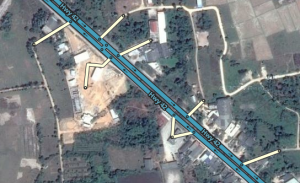
If you insist on locking roads in an unfinished area, try stubbing. Stubbing is making a short low-level segment for each exit that a low-level editor can attach to.
You can become area manager by filling out this form. You will then also be invited to join WazeUAE on Slack.
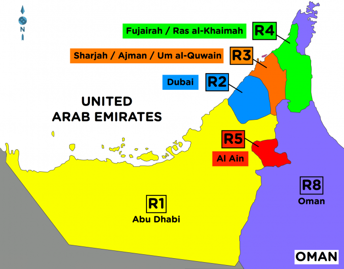
Regions
The country is divided into 5 major regions:
- R1 Abu Dhabi
- R2 Dubai
- R3 Sharjah/Ajman/Um al-Quwain
- R4 Fujairah/Ras al-Khaimah
- R5 Al Ain
To help our neighbours in Oman, there's an Oman channel to help that community.
- R8 Oman
Each region has it's own dedicated channel on Slack UAE, for handling local requests.
Management
| # | Region | RM | |
|---|---|---|---|
| 1 | Emirate of Abu Dhabi | bazgrant, houstonmg, moosool, nautilus67 | |
| 2 | Emirate of Dubai | timspilman, jamesmdino, rickynaul, dxblouie, danilo-p, pulsarxp | |
| 3 | Emirates of Sharjah; Ajman; Umm al-Quawain | TBD | |
| 4 | Emirates of Ras al-Khaimah; Fujairah | TBD | |
| 5 | City of Al Ain; | simonuae |
