(→City Names: Updated the city names standard to include bilingual text) |
|||
| (ไม่แสดง 116 รุ่นระหว่างกลางโดยผู้ใช้ 5 คน) | |||
| บรรทัดที่ 1: | บรรทัดที่ 1: | ||
''บทความนี้เป็นภาษาอังกฤษ สำหรับภาษาไทยคลิก[[/ภาษาไทย|ที่นี่]]''<br/> | ''บทความนี้เป็นภาษาอังกฤษ สำหรับภาษาไทยคลิก[[/ภาษาไทย|ที่นี่]]''<br /> | ||
''For the wiki.waze.com of Thailand visit [https://wiki.waze.com/wiki/Thailand here]'' | ''For the wiki.waze.com of Thailand visit [https://wiki.waze.com/wiki/Thailand here]'' | ||
= Hello | ='''Hello Everyone and Welcome to Waze Thailand!'''= | ||
We have an [https://www.waze.com/forum/viewforum.php?f=168 official forum], a [https://www.facebook.com/ | We have an [https://www.waze.com/forum/viewforum.php?f=168 official forum], a [https://www.facebook.com/WazeThai not so official Facebook group], and a [https://www.facebook.com/ThaiWazer larger unofficial Facebook group.] | ||
and a [https://www.facebook.com/ThaiWazer larger unofficial Facebook group.] | |||
The Thai map attracts a lot of foreign editors, so this page is in English. We are actively looking for people who live in Thailand for help editing and localizing the map! | |||
We had a very successful MapRaid in September 2015 [[/MapRaid_Thailand|MapRaid_Thailand]]. This MapRaid was the start of self-management in Thailand. | |||
We | |||
='''Join the Waze Thailand Editor Community!'''= | |||
We use SLACK as the primary communication tool for editors in Thailand. If you plan or wish to edit the map in Thailand, please join the editing community on SLACK. When you set up your SLACK account, please use your Waze username as your SLACK username so we can easily match the edits with the discussion. | |||
Link to join the Thailand Editor Community on SLACK is here: [https://join.slack.com/t/wazethailand/shared_invite/zt-edio4mhi-~nhkMIxHrx3UNj61WQNuPg Thailand Editor Community on SLACK] | |||
= Editing the | ='''Editing the Map'''= | ||
If you already have general editing experience, please continue reading [[Thailand:หน้าหลัก#Names_in_general|here]] to learn about the things we do a little bit different in Thailand compared to the rest of the world. | If you already have general editing experience, please continue reading [[Thailand:หน้าหลัก#Names_in_general|here]] to learn about the things we do a little bit different in Thailand compared to the rest of the world. | ||
| บรรทัดที่ 25: | บรรทัดที่ 26: | ||
For a more in-depth understanding of Map editing, we recommend you read the [[Global:Waze_Map_Editor|Waze Map Editor page]]. | For a more in-depth understanding of Map editing, we recommend you read the [[Global:Waze_Map_Editor|Waze Map Editor page]]. | ||
As a new editor, you are likely to make some mistakes in making changes to the map. | As a new editor, you are likely to make some mistakes in making changes to the map. If you need help learning or encounter any problems using a new technique or are unsure of how to make a particular edit, please ask for help from a member of the Thailand Editor Community or a member of the Thai management team. We are all here to help you learn and contribute to the overall improvement of the Thailand Waze map for everyone’s benefit. | ||
{{mbox | {{mbox | ||
| type = critical | | type = critical | ||
| text = '''You may only use the following sources to change/update the map:''' | | text = '''You may only use the following sources to change/update the map:''' | ||
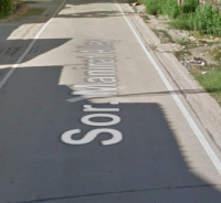
- '''Waze''' Street View (but NOT the road names | - '''Waze''' Street View (but NOT the road names projected on the street surface) | ||
<br /> | <br /> | ||
[[File:Thailand_SV_road_name.png|200px]] | [[File:Thailand_SV_road_name.png|200px]] | ||
| บรรทัดที่ 43: | บรรทัดที่ 44: | ||
When you think you understand enough of the basic concept of map editing, please continue reading below to learn about the Thai way of Map Editing! | When you think you understand enough of the basic concept of map editing, please continue reading below to learn about the Thai way of Map Editing! | ||
== Names in | =='''Names in General'''== | ||
It is sometimes not very clear what the name of a road or place is called. When in doubt, the names should remain empty (check the “none” box in the street name on WME) but you '''MUST''' include the proper city name for its location, if applicable. Hopefully, an editor with local knowledge will improve it. Please see the section titled '''"City Names"''' for more information on locating the correct city names. | |||
You can find many place and street names on WME street-view by looking for the signs the drivers will see. | |||
=='''Bilingual Map Project'''== | |||
For several years, we have been trying to convince Waze HQ that the Thailand Waze map needed to be bilingual in order to attract more users. The technical changes required were deemed too intensive for HQ to take on therefore we decided to take matters into our own hands and create a bilingual map that works for both Thai and English Wazers. | |||
The ultimate goal is to create a map that displays both Thai and English street names and TTS driving instructions which only speak the Thai or English portion of the street names depending on the TTS language the app users select. | |||
After several months of testing on a few Minor Highways in Bangkok, the project has now been refined to the point of expanding it throughout Metropolitan Bangkok. Once Metropolitan Bangkok is completed and we’ve worked out any issues we may encounter during the implementation, we will expand to the other provinces. | |||
===Bilingual Naming Format=== | |||
In order for the TTS to distinguish between the two languages, we have to have a “separator” to signal the start and end of the different text. In collaboration with the HQ TTS team, we determined that the best separator to use is the “+” symbol. | |||
The format for entering the bilingual street names is: “+_ThaiScript_+_EnglishScript”. Note the “_” indicated “blank” spaces between the text. | |||
Examples: | |||
+ ถนนอ่อนนุช + On Nut Rd | |||
+ ถนนลาดกระบัง + Lat Krabang Rd | |||
+ ทางพิเศษบูรพาวิถี + Burapha Withi Expressway | |||
===How You Can Help=== | |||
As we are sure you will agree, this is a monumental undertaking and will take a huge team effort to accomplish. | |||
We have a live Google Sheet that is divided by Editing Regions for all of Thailand. On the sheet we need to add the English Name and Thai Name (Thai Script) for every street. English language editors can contribute by entering the English Names and the Thai language editors can contribute by entering the Thai Script on the sheet. Please make sure the spelling (in both languages) is correct. Once the street names have both languages on the sheet, any editor (regardless of language) can copy the names from the sheet and add them to the WME map using the format shown above. Please make sure the correct names are added to the correct streets and that the format is exactly as above. | |||
Here is the link to the Google Sheet for the Bilingual Project: [https://docs.google.com/spreadsheets/d/1JIe1fODpwauZSzwrqaI15ieCDfkMmYwVPZCdkhailcY/edit#gid=845098164 Thailand Bilingual Name Sheet] | |||
'''''Note: Please add your name to the sheet after you have completely renamed a street to the new format.''''' | |||
== English in | While we are only implementing this in Metropolitan Bangkok (R5) at the moment, editors in other regions can get a head start on entering the street names for their regions so they can be ready for a Thai editor to add the Thai script. | ||
Please remember, SLOW editing with great attention to detail is required to create a great map for all to use. This project is extremely important for the future of Waze Thailand and quality edits are a MUST. | |||
As always, if there are any doubts about any aspect of this or any other project, please ask a senior member of the Thai Editing team or a member of the management team. We are all on the same team and will be happy to help you learn so you can contribute more to the overall success of Waze Thailand. | |||
=='''English in Names'''== | |||
We should try to match names to local signage when official signs with romanization are available. | We should try to match names to local signage when official signs with romanization are available. | ||
| บรรทัดที่ 56: | บรรทัดที่ 92: | ||
[https://www.waze.com/forum/viewtopic.php?f=168&t=13915 Nobody agrees how to write Thai using the Roman alphabet.] | [https://www.waze.com/forum/viewtopic.php?f=168&t=13915 Nobody agrees how to write Thai using the Roman alphabet.] | ||
=== Dictionary === | ===Dictionary=== | ||
Ban: village (more or less.)<br /> | Ban: village (more or less.)<br /> | ||
| บรรทัดที่ 70: | บรรทัดที่ 106: | ||
Example: "Wat Rong Khun" | Example: "Wat Rong Khun" | ||
=== Standardize Transliteration === | ===Standardize Transliteration=== | ||
Below is a list of common Thai words that have multiple transliterations and the official spelling to be used in Waze. | Below is a list of common Thai words that have multiple transliterations and the official spelling to be used in Waze. | ||
| บรรทัดที่ 77: | บรรทัดที่ 113: | ||
Use [https://www.waze.com/forum/viewtopic.php?f=1406&t=163961 this thread] to propose additional words that should have a standardized transliteration added to the wiki. | Use [https://www.waze.com/forum/viewtopic.php?f=1406&t=163961 this thread] to propose additional words that should have a standardized transliteration added to the wiki. | ||
== City | =='''City Names'''== | ||
We have 2 format standards for city names in Thailand. One standard for Metropolitan Bangkok and another for the rest of the country (up-country). This is due to the large density of Bangkok and to prevent the map from being cluttered. | |||
[[File:Villagesign.jpg|thumbnail|Sign for a Thai village, with breakdowns on what each section means.]] | |||
'''Up-Country City Name Standard - Bilingual''' | |||
The standard city name format to be applied country-wide (except in Metropolitan Bangkok) is to include both English and Thai script in the names: "Tambon (English) Tambon (Thai) - Amphoe (Changwat)". For example: “Bang Sai Yai ตำบล บางทรายใหญ่ - Mueang Mukdahan (Mukdahan)”. | |||
Note: There must be a space before and after the Thai script. If the properly formatted city name is not already added on WME, please request it to be added by a member of the Thailand CM team. | |||
'''Bangkok Metropolitan City Name Standard - Bilingual''' | |||
To prevent the map from being over-cluttered with city names, the following standard is applied to all city names in the Metropolitan Bangkok region: “Khet Name (English) Khet Name (Thai), Bangkok”. For example: “Prawet ประเวศ, Bangkok”. | |||
Note: There must be a space between the English text and the Thai script. | |||
'''Note:''' Every segment within the boundaries of the city should be named, except for small lakes/ponds, railroad segments, and rivers. | |||
When in doubt, leave the city field blank by checking the "None" box. | |||
'''Useful WME Scripts and Resources for City Names''' | |||
'''WME Color Highlights:''' This script allows you to highlight every segment and place within a city to check the naming consistency. | |||
https://greasyfork.org/en/scripts/3206-wme-color-highlights | |||
'''Google Maps''': Google maps can be used to “verify” the city borders. Note: The use of information from Google Maps (street names, city names, place names, etc.) is NOT allowed under any circumstances. '''''Failure to comply with this rule will result in your editing rights being revoked.''''' | |||
If you need help using any of the scripts, or have any questions about acceptable external sources of information, please reach out to others in the community and ask for help. | |||
=== City Smudging === | ===City Smudging=== | ||
<br /> | <br />City smudging is caused when road segments are given a city name that lies far beyond the actual borders of the town or city. This is mostly caused by the editor using the city name that displays on the top left of the WME screen, which is not correct a lot of the time. To ensure accuracy, Editors should always base the city names on the actual boundaries of the city and disregard the city name displayed on the WME screen. | ||
Here is an example of a smudged city on the Thailand map: | Here is an example of a smudged city on the Thailand map: | ||
[[ไฟล์:Smudged cityname.png|left|thumb|885x885px|Example of a smudged city on the Thailand map.]] | |||
Here is an example of well-defined cities: | |||
[[ไฟล์:WellDefinedCities.jpg|left|thumb|889x889px|Example of well-defined city names.]] | |||
ALL road segments that cross city boundaries should be split at the correct boundary to prevent smudging. | |||
Attention needs to be taken when naming Places to make sure the correct city names are used as well. | |||
For more details on city smudging and how to resolve/remove them, see [[global:Smudged_cities|Smudged Cities]] | For more details on city smudging and how to resolve/remove them, see [[global:Smudged_cities|Smudged Cities]] | ||
---- | |||
== Roads == | =='''Roads'''== | ||
* Thailand is a [[global:LHT|left hand traffic]] country. Cars drive on the left. | *Thailand is a [[global:LHT|left hand traffic]] country. Cars drive on the left. | ||
* Some satellite photos | *Some satellite photos have shifted over time and with satellite view updates (in the wrong place) or out of date. When encountering areas that have shifted, please take the time to realign the segments to the center of the roadway on the satellite view. Please use care and make sure your editing at least at a Level 8 zoom when adding or realigning road segments. For new roads that are not updated on the satellite view of WME, please use the WME GPS layer to make sure the roads are in the correct place. They can be updated and realigned again once the satellite views are updated. | ||
*Only the satellite and street views available from within WME may be used when editing the map. Local knowledge may be used. [[global:Using_external_sources|External sources of information may not be used]]. '''''Failure to comply with this rule will result in your editing rights being revoked.''''' | |||
[https://en.wikipedia.org/wiki/Thai_highway_network General information on wikipedia], and | [https://en.wikipedia.org/wiki/Thai_highway_network General information on wikipedia], and | ||
[https://en.wikipedia.org/wiki/Road_signs_in_Thailand road signs] for those parts that have | [https://en.wikipedia.org/wiki/Road_signs_in_Thailand road signs] for those parts that have Streetview. | ||
===Street Names (English)=== | |||
The street names in WME '''MUST''' match the official local signage. If there are no official signs indicating the street name, the name is to be left empty by checking the “none” box on the WME street name. This assures the instructions given in Waze match what drivers are seeing to avoid confusion that might lead to an accident or missed turn. | |||
The following naming rules should be applied to all street names: | |||
*'''Trok''' or '''Thanon''' should be removed from the street name and Rd added to the end of the name. Do not put a . after Rd. | |||
Example: "Thanon Rama 9" in Bangkok should be named "Rama 9 Rd". | |||
Example: "Thanon | |||
*'''“Soi”''' should only be added to the named street if the visible street signs include the word. Do not add Rd or Alley to the end of the name. Soi's are side-streets off of the main roads. Please use the same name that is exactly shown on the sign the Wazers will see. When naming the soi’s you should use the following format: | |||
'''<Parent Street Name> <Soi 'if present'> <Number>''' | |||
**Example from the picture: Soi 106 of Thepharak Rd would be entered as '''Thepharak 106''' | |||
Example: Soi | |||
[[File:SoiStreetSign.png|thumb|right|300px|Thepharak 106 with Alternative Name]] | |||
<br /> | |||
<br /> | |||
<br /> | |||
<br /> | |||
<br /> | |||
<br /> | |||
<br /> | |||
<br /> | |||
<br /> | |||
<br /> | |||
<br /> | |||
<br /> | |||
**Example from the picture: Soi 22 of Chaloem Phrakiat Ratchakan Thi 9 would be entered as '''Chaloem Phrakiat Ratchakan Thi 9 Soi 22''' because 'Soi' is present in the sign | |||
[[File:SoiStreetSign_soi_present.png|thumb|right|300px|Chaloem Phrakiat Ratchakan Thi 9 Soi 22]] | |||
<br /> | |||
<br /> | |||
<br /> | |||
<br /> | |||
<br /> | |||
<br /> | |||
<br /> | |||
<br /> | |||
<br /> | |||
<br /> | |||
<br /> | |||
<br /> | |||
In some cases, Soi's will have a second name which does not reference the major street or the soi number. These should be added as an alt name. | In some cases, Soi's will have a second name which does not reference the major street or the soi number. These should be added as an alt name. | ||
If local signage references the soi | Example: Thepharak 106 is also known as Soi Thephaniwet 2. So we should add the alternative name of "'''Soi Thephaniwet 2"''' to these segments. | ||
If local signage references the soi name and not the number, it is ok to use the name as the primary street name, and the number as the alt. | |||
Leave the street name empty by checking the “none” box for the street name if there are no visible signs with the street name for the drivers to see. | |||
The name of the road in Thai script can be added as an alternate name, if known and the editor is able to confirm the accuracy of the text. | |||
You can always "add the alternate name" to give a road more than one name. Use this when a road name has multiple ways to spell it. The Primary Name '''MUST''' always match the actual signs the drivers see. | |||
<br /> | |||
<br /> | |||
===Highways=== | |||
All highways in Thailand are numbered. The number of digits in the number indicates the role for that section of roadway and can be used to help match the classifications used in Waze. There are a few exceptions. | |||
'''Naming''' | |||
''' Motorways & Expressways ''' | We '''MUST''' match the naming of highways to the signs drivers are most likely to encounter. The general naming rule is to name the road Hwy followed by the number of the highway (Ex. Hwy 4029). In some areas, these highways may also have a local road name. If you know this name and are confident of where the use of the name starts and ends, you may add it in parentheses “()” after the road number. If you are unsure, leave the road name out, or add it as an alt name. For example: “Hwy 3344 (Srinagarindra Rd)”. | ||
Motorways have both names and numbers, while Expressways only have names. | |||
Many highways also have a secondary number as part of the Asian Highway Network. These numbers can be added as an alt name when known. Do not include the Asian Highway number in the primary name. | |||
'''Motorways & Expressways '''[[File:thailand_rural_road.jpg|thumbnail|An example of a rural road sign.]] | |||
Motorways have both names and numbers, while Expressways only have names. Name Expressways as they are officially called. Motorways should be entered as their Route number followed by their name (if they have one). | |||
Example: “Route 7, Bangkok - Chonburi Motorway”, “Route 9, Bangkok Outer-Ring Rd (East)”, and “Si Rat Expressway”. | |||
'''Rural Roads''' | '''Rural Roads''' | ||
Rural Roads are highways managed by the local province (ChangWat). They follow the same naming conventions as federally managed highways, except with the inclusion of a two-character prefix indicating the province that maintains them. These follow the same naming and classification as a federal highway, however, we replace "Hwy" with "Rural Rd" before the number. In March 2018 we decided to include the province abbreviation from this [https://docs.google.com/spreadsheets/d/1-bNBCi6GEKjkhMzmMQ7dPrn4BKSUEkMpFGPucZFIfBg/edit?usp=sharing '''Changwat List'''] . | |||
Example: "'''Rural Rd ปท 3022'''", where the two Thai characters is the abbreviation of the province. Please note that many Rural Roads continue through more than one province and care should be taken to ensure the correct province abbreviation is used based on the actual location on the map. | |||
{| class="wikitable" | {| class="wikitable" | ||
|- | |- | ||
! # of Digits !! Waze Class !! Completed Lock !! Naming Example | !# of Digits!!Waze Class!!Completed Lock!!Naming Example | ||
|- | |- | ||
| 1 || {{Freeway}} || L5 || Hwy 1 (Phahonyothin Rd) | |1||{{Freeway}}||L5||Hwy 1 (Phahonyothin Rd) | ||
|- | |- | ||
| 2|| {{Freeway}} || L5 || Hwy 36 | |2||{{Freeway}}||L5||Hwy 36 | ||
|- | |- | ||
| 3 || {{Major Highway}} || L4 || Hwy 305<br /> Hwy 407 (Kanchana Wanit Rd) | |3||{{Major Highway}}||L4||Hwy 305<br /> Hwy 407 (Kanchana Wanit Rd) | ||
|- | |- | ||
| 4&5 || {{Minor Highway}} || L3 || Rural Rd 4027 <br /> Hwy 2085 (Poonnakan Rd) | |4&5||{{Minor Highway}}||L3||Rural Rd รย 4027 <br />Hwy 2085 (Poonnakan Rd) | ||
|- | |- | ||
| Motorway || {{Freeway}} || L5 || Chonburi Motorway | |Motorway||{{Freeway}}||L5||Route 7, Bangkok - Chonburi Motorway | ||
Route 9, Bangkok Outer-Ring Rd (East) | |||
|- | |- | ||
| Expressway|| {{Freeway}} (Toll) || L5 || Si Rat Expressway | |Expressway||{{Freeway}} (Toll)||L5||Si Rat Expressway | ||
Chaloem Maha Nakhon Expressway | |||
|} | |} | ||
The 'Completed Lock' is the level to lock a road segment once it is completely finished and stubbed. | The 'Completed Lock' is the level to lock a road segment once it is completely finished and side roads are stubbed. | ||
Further reading on the [https://en.wikipedia.org/wiki/Thai_highway_network Thai highway network]. | Further reading on the [https://en.wikipedia.org/wiki/Thai_highway_network Thai highway network]. | ||
=== Ramps === | '''Note:''' Long stretches of road outside of cities, that connect many villages and towns, should be set to Minor Highway (mH) type to help with long distance routing, especially if these roads are the primary route to access the towns and villages. | ||
{{Ramp}} Entrance or Exit to or from freeways and highways. | |||
Lock | ===Ramps=== | ||
{{Ramp}} Entrance or Exit segments to or from freeways and highways. | |||
Lock level: The same lock level as the highest lock on the connected freeway or highway segments. | |||
Naming: The names '''MUST''' exactly match the signs the drivers see on the road. Follow the Big Green Sign (BGS) or the Big Blue Sign (BBS) (expressways) | |||
Name them by adding "to" before the destinations shown on the BGS or BBS signs. If the exit has an exit number, then add the Exit # before the name instead of using “to”. | |||
Examples: | |||
No Exit #: “to Suvarnabhumi Airport, Passenger Terminal Bldg” and “to Ram Inthra, Bang Na”. | |||
Exit #: “Exit 14: Kaset - Nawamin Rd” and “Exit 1C: Rama 9 Rd”. | |||
'''Note:''' Ramps are '''NOT''' to be used for U-Turns or with any other type of road. They are only to be used as entrance or exit segments for Freeways and Highways. There are exceptions to this. Please consult with the Thai management before applying any exceptions. | |||
=== Primary Street === | ===Primary Street=== | ||
{{Primary Street}} | {{Primary Street}} Primary Streets are also known as main roads that connect towns or villages together. They are normally 2-4 lanes and include a hard shoulder for emergency use. There are some exceptions. Please consult with the Thai management before applying any exceptions. | ||
Lock Level : L2 | |||
Naming: The names '''MUST''' exactly match the signs the drivers see on the road and follow the naming format previously outlined. | |||
Examples: “Charoen Nakhon Rd”, “Chan Rd”, and “Sukhumvit 55”. | |||
=== Street === | ===Street=== | ||
{{Street}} Any Soi and Trok, small and provincial roads which are not main streets. | {{Street}} Any Soi and Trok, small and provincial roads which are not main streets. | ||
Lock Level: L1 | |||
Naming: The names '''MUST''' exactly match the signs the drivers see on the road and follow the naming format previously outlined. | |||
=== | ===Off-road / Not maintained Road (formerly 4x4 (dirt) Road)=== | ||
{{ | {{Dirt Road / 4X4 Trail|Off-road}} A road that is physically impossible to drive by a normal car, and should be avoided when possible. For example, a road that goes through a shallow river, badly rutted, or a road that is less than one car wide. | ||
'''Note:''' Roads marked as "Off-Road / Not Maintained" will '''NOT''' be used for navigation and therefore should '''NOT''' be added to the map unless there is a specific benefit in showing it on the map. Please consult with the Thai management before applying any exceptions. | |||
'''Additional Note:''' Type Off-road will be used when there’s no other route possible. IF there’s another possible route then Waze will use that even if this means 4 hours extra driving. | |||
===Unpaved (Dirt or Gravel) Road=== | |||
Dirt Roads: Regular streets, without pavement, but for normal use, should be mapped as the type of street that is appropriate (PLR, LS, PS, or mH) and marked "unpaved", so that they can be used for navigation. | |||
<br /> | ===Private Road=== | ||
{{Private Road}} A road that goes to a single house, or onto the private property of a gated housing community with controlled access. Only the entrance segment should be set as "private" and locked at L3 to prevent unauthorized changes. | |||
Lock Level: L3 | |||
Naming: Naming: The names '''MUST''' exactly match the signs the drivers see on the road and follow the naming format previously outlined. If the names are unknown or there are no signs, the names should remain empty (check the “none” box in the street name on WME) but should include the proper city name for its location. | |||
===Parking Lot Road=== | |||
{{Parking Lot Road}} Parking lot roads within places such as shopping malls, offices, factories, industrial estates, government complexes, etc. It's not necessary to draw every Parking Lane of a large parking lot. The entrances and exits should be clearly mapped. | |||
Lock Levels: normal parking lots: L1; Gas Station parking lots: L3 | |||
Naming: Parking lot roads must '''NOT''' be named (check the “none” box in the street name on WME) but should include the proper city name for its location. Please consult with the Thai management before applying any exceptions.<br /> | |||
===Railroads=== | |||
{{Railroad}} Railroad segments are used to show the location of railroads, elevated, at street level, underground (subway), etc. | |||
Lock Level: L5 | |||
Naming: The Railroad name '''MUST''' match the actual name of the railroad line. | |||
Examples: “BTS Sukhumvit Line”, “MRT Blue Line”, and “Thai Railway”. | |||
Railroad segments should '''NOT''' include any city name (check the “none” box in the city name on WME). | |||
Direction: 2-way | |||
Elevation: actual level | |||
Railroad Crossing warning alerts '''MUST''' be added to '''EVERY''' crossing that physically crosses a road segment at street level. | |||
=== | ===Walking Trail, Pedestrian Boardwalk, Stairway, Runway / Taxiway, Narrow Street.=== | ||
Since these types of segments are not used for navigation or incur large penalty times, they should '''NOT''' be added to the map in Thailand. Please consult with the Thai management before applying any exceptions. | |||
'''Note:''' Narrow Streets are not used as “motorcycle” streets because they will still allow navigation for cars and other vehicles types, albeit with a slight time penalty. In cases where the street is physically impossible for normal vehicle traffic and only allowed for motorcycles, it is best to map them as normal “local street” type and add a restriction to the segments to only allow motorcycles. These types of segments should be locked at L3 to prevent unauthorized or unintended changes. If there is any doubt whether normal vehicles can use the segments, please ask the Thai management team to check the segments before applying the restrictions. | |||
==Road markers on StreetView== | =='''Road markers on StreetView'''== | ||
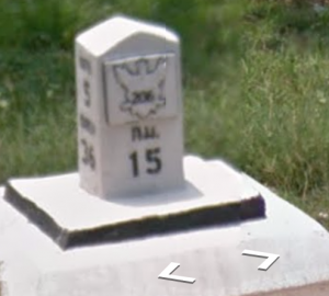
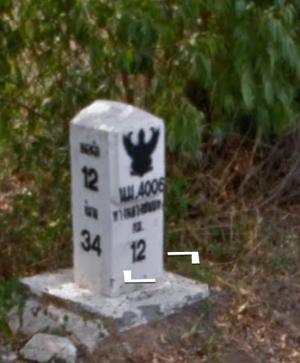
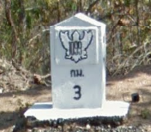
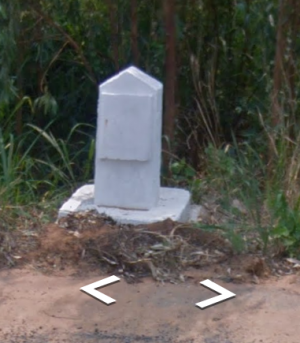
When adding new roads, it is not always easy to find out what type of road to apply. | When adding new roads, it is not always easy to find out what type of road to apply. | ||
Use the road markers next to the major roads to determine what to apply. | Use the road markers next to the major roads to determine what to apply. | ||
| บรรทัดที่ 253: | บรรทัดที่ 393: | ||
{| class="wikitable" | {| class="wikitable" | ||
|- | |- | ||
! Picture !! Classification | !Picture!!Classification | ||
|- | |- | ||
| | | | ||
[[File:Hwy11.png|thumbnail|center]] | |||
|| [[หน้าหลัก#Freeway|Freeway]] | ||[[หน้าหลัก#Freeway|Freeway]] | ||
|- | |- | ||
| | | | ||
[[File:Hwy 206.png|thumbnail|center]] | |||
|| [[หน้าหลัก#Major_Highways|Major Highway]] | ||[[หน้าหลัก#Major_Highways|Major Highway]] | ||
|- | |- | ||
| | | | ||
[[File:Hwy 4006.png|thumbnail|left]] | |||
[[File:Minorhwyii.png|thumbnail|right]] | |||
|| [[หน้าหลัก#Minor_Highways|Minor Highway]] | ||[[หน้าหลัก#Minor_Highways|Minor Highway]] | ||
|} | |} | ||
| บรรทัดที่ 273: | บรรทัดที่ 413: | ||
{| class="wikitable" | {| class="wikitable" | ||
|- | |- | ||
! Picture !! Classification | !Picture!!Classification | ||
|- | |- | ||
| | | | ||
[[File:Minornew.png|thumbnail|center]] | |||
|| [[หน้าหลัก#Minor_Highways|Minor Highway]]. | ||[[หน้าหลัก#Minor_Highways|Minor Highway]]. | ||
|- | |- | ||
| | | | ||
[[File:Minorold.png|thumbnail|center]] | |||
|| [[หน้าหลัก#Minor_Highways|Minor Highway]]. | ||[[หน้าหลัก#Minor_Highways|Minor Highway]]. | ||
|} | |} | ||
| บรรทัดที่ 289: | บรรทัดที่ 429: | ||
{{mbox | {{mbox | ||
| type = notice | | type = notice | ||
| text = Low Priority Task: if you find a marker in | | text = Low Priority Task: if you find a marker in Streetview, please add it to the map. These markers can help us identify specific stretches of Highway. Use a Point Place of type Junction/Interchange; name it Hwy [xx] km [xx]}} | ||
=='''Special Road Situations'''== | |||
===U-Turns=== | |||
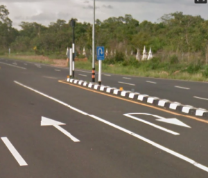
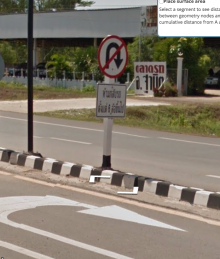
On Freeways and Highways in Thailand that have divided lanes, there are often designated U-Turn areas created. They can be recognized by both road signs indicating a U-Turn, as well as a U-Turn arrow on the road surface itself. | |||
[[File:Uturn_sign_and_marking.png|300px]] [[File:Nouturnfortrucks.png|220px|Prohibited for trucks with more than 6 wheels]] | |||
Sometimes a U-Turn is prohibited for trucks, this is indicated by a text sign under the "U-Turn prohibited" sign. | |||
On smaller roads, there may not be specific signage indicating a U-Turn area, but unless there are specific road signs that prohibit U-Turns, they are generally allowed. | |||
====Naming of U-Turns - Bilingual==== | |||
U-Turns should be named as follows, depending on the type of U-Turn: | |||
#Normal U-Turns = "+ กลับรถ + U-Turn" | |||
#U-Turn Bridge = "+ สะพาน กลับรถ + U-Turn Bridge" | |||
#U-Turn with clearance of 2.5 meter or less = "+ กลับรถ ความสูงไม่เกิน <u>2.3</u> เมตร + U-Turn <u>2.3</u> Meter Clearance" | |||
Please also include the correct city name for the U-Turn segments. | |||
====U-Turn Construction==== | |||
To ensure proper driving instructions, there are several construction options available. Please see the [[Thailand/uturns|U-Turn constructions page]]. | |||
=== Frontage Roads === | ===Frontage Roads=== | ||
A frontage road (also known as an access road, service road, parallel road, etc.) is a local road running parallel to a higher-speed, limited-access road. A frontage road is often used to provide access to private driveways, shops, houses, industries or farms. | A frontage road (also known as an access road, service road, parallel road, etc.) is a local road running parallel to a higher-speed, limited-access road. A frontage road is often used to provide access to private driveways, shops, houses, industries or farms. | ||
In | Officially both the frontage road and the main roads use the same name. In order to provide the best and most accurate driving instructions, we use the following naming and classification principles in Thailand: | ||
Outside lanes (the frontage roads) are named as "Name_Frontage Rd" and may contain house numbers. The frontage roads are typically classified as ''{{Primary Street}}'' or {{Minor Highway}}'' ''depending on the other routing connections that may be connected to the frontage roads. | |||
Examples of frontage road names: “Motorway Frontage Rd”, “Phaholyothin Frontage Rd”, and Rama 9 Frontage Rd”. | |||
Inside (faster, through-traffic) lanes are named with the normal name and format for the street type. The main road is classified at the normal classification for the type of road and should remain consistent throughout. | |||
Examples of main road names: “Route 7, Bangkok - Chonburi Motorway”, “Hwy 1 (Phaholyothin)”, and “Rama 9 Rd”. | |||
If elevated lanes are also present, they are named as "Street name_Elevated", “Street name_Bridge”, or “Street name_Overpass”, or other name, depending on the local naming of each type of elevated road. To maintain routing consistency, the elevated segments are typically classified the same as the main roads they are connected to. | |||
Examples of elevated road names: “On Nut Rd Overpass”, “Rama 9 Sky Rd”, and “Uttaraphimuk Elevated Tollway”. | |||
Please consult with the Thai management before applying any exceptions. | |||
=== Roads | ===Roads Along a Canal (Khlong Roads)=== | ||
When a canal has a road on each side, they are seen as separate roads. | When a canal (khlong) has a road on each side, they are seen as separate roads. Most are 2-way street but there are some exceptions. | ||
=== Dividing | Please check the street view closely when adding new canal roads to make sure they are accurate and reflect the situation drivers will see on the ground. Note that some of the canal roads are different classifications than the other side and care should be taken to classify them correctly to ensure the majority of traffic is sent to the most suitable route.[[File:Canal roads.png|thumbnail|center]] | ||
===Dividing Roads=== | |||
{{mbox | {{mbox | ||
| type = notice | | type = notice | ||
| text = Dividing existing roads is a low priority task. | | text = Dividing existing roads is a low priority task. | ||
This should only be done when drawing in new roads, solving a UR, or as one of the last things you do in your management area before requesting a new one. | |||
If you want to divide an existing road, please consult with the Thai management first. | |||
}} | }} | ||
It should be noted that we are not trying to create a map that copies every visible attribute of each road. We are creating a map that is used to provide “driving directions” to users who are viewing the map via the Waze app on a small device screen. Small divided roads that are close together and those that are not physically divided with an impassable barrier should NOT be divided on the WME map. The turn restrictions can be used to properly manage the flow of traffic for small divided roads without cluttering the map view. It should be noted that dividing small close together roads may result in undesirable driving instructions which can cause confusion possibly resulting in missed turns or causing accidents. | |||
''Before dividing any existing road, please consult with the Thai management for advice and direction.'' [[File:Split road.png|thumbnail|center]] | |||
'''Divide:''' | |||
[[File:THSmallMedian.jpg|300px]] [[File:THLargeMedian.jpg|300px]] | |||
'''Do Not Divide:''' | |||
[[File:Nodivide2.png|300px]] [[File:THPaintedMedian.jpg|300px]] | |||
See the [[หน้าหลัก#U-Turns|U-Turn section]] for instructions on how to properly hand dedicated U-Turn lanes on divided roads. | See the [[หน้าหลัก#U-Turns|U-Turn section]] for instructions on how to properly hand dedicated U-Turn lanes on divided roads. | ||
===Turn Instruction Overrides (TIO's)=== | |||
The majority of connections on the map can be edited with the correct junction angles to provide the correct TTS instructions therefore the use of TIO’s on the WME map should be '''rare'''. | |||
The use of the “WME Junction Angle Info” (JAI) script is deemed '''<u>mandatory for editors in Thailand</u>'''. If you are not using it, please install it now. | |||
[https://greasyfork.org/en/scripts/35547-wme-junction-angle-info WME Junction Angle Info (link)] | |||
There are some rare cases that cannot be addressed with junction angles. In these special cases, TIO’s can be used to provide the desired TTS instructions to the drivers. | |||
Please check the [[Thailand/Turn_Instruction_Overrides|Turn Instruction Override (TIO) page]] for Thailand specific guidance on the use of TIO's. | |||
Please consult the Thai management if you have questions regarding the use of TIO’s. | |||
== Places == | =='''Places'''== | ||
Follow [//wiki.waze.com/wiki/Places the general guidelines] with the additions below: | Follow [//wiki.waze.com/wiki/Places the general guidelines] with the additions below: | ||
=== Coastline Issues === | ===Coastline Issues=== | ||
There are still many parts of the map where (part of) the land appears to be water. This issue shows in the app (client) or Livemap. Ideally, these should be corrected at Waze HQ level but this is a very low priority. You can fix these 'coastline' issues yourself by making an island area place over the inundated land. After creating the island you wait until it's visible on the livemap and tweak the area until it's perfect. Don't name the island but give it a description like "coastline problem". Then ask to lock it at lvl5. | There are still many parts of the map where (part of) the land appears to be water. This issue shows in the app (client) or Livemap. Ideally, these should be corrected at Waze HQ level but this is a very low priority. You can fix these 'coastline' issues yourself by making an island area place over the inundated land. After creating the island you wait until it's visible on the livemap and tweak the area until it's perfect. Don't name the island but give it a description like "coastline problem". Then ask to lock it at lvl5. | ||
=== Place Names === | ===Place Names=== | ||
The primary name for places should be the romanized (English) version of the name. If you know the name in Thai and can input it, add it as an alt name. | The primary name for places should be the romanized (English) version of the name. If you know the name in Thai and can input it, add it as an alt name. | ||
=== Addresses === | ===Addresses=== | ||
Thai addresses contain a lot of information that can not be easily adapted to the default fields found in WME. | Thai addresses contain a lot of information that can not be easily adapted to the default fields found in WME. | ||
Do add city and street as usual, but for now, the complete address can go into the '''description''' field of the place (if you know it.) | Do add city and street as usual, but for now, the complete address can go into the '''description''' field of the place (if you know it.) | ||
=== Point vs Place === | ===Point vs Place=== | ||
Thailand differs from the global standard when it comes to using area places vs point places. Due to many streets having no name or signage (both in real life and in Waze), any significant landmark can be entered as an area place to help with visual navigation. These can be temples, schools, government offices, or any visually distinct business. Area places may not be needed in urban or well-signed areas; use your best judgement to decide when an area place is required. | Thailand differs from the global standard when it comes to using area places vs point places. Due to many streets having no name or signage (both in real life and in Waze), any significant landmark can be entered as an area place to help with visual navigation. These can be temples, schools, government offices, or any visually distinct business. Area places may not be needed in urban or well-signed areas; use your best judgement to decide when an area place is required. | ||
| บรรทัดที่ 369: | บรรทัดที่ 541: | ||
Keep in mind that Waze does not render smaller area places. The exact size limitations have not been defined, but at the time of this writing, it appears areas need to be at least 25m x 35m to be visible in the app. For important landmarks, it may be permissible to draw the area larger than the actual property line to insure visibility in the app. | Keep in mind that Waze does not render smaller area places. The exact size limitations have not been defined, but at the time of this writing, it appears areas need to be at least 25m x 35m to be visible in the app. For important landmarks, it may be permissible to draw the area larger than the actual property line to insure visibility in the app. | ||
=== Natural Features === | ===Natural Features=== | ||
Natural features that are large enough to render in the app and visible from the road should be added as area places. | Natural features that are large enough to render in the app and visible from the road should be added as area places. | ||
=== Point Places === | ===Point Places=== | ||
Point places should only be added to the map when the name of the business is known. | Point places should only be added to the map when the name of the business is known. | ||
=== Parking Lot Areas === | ===Parking Lot Areas=== | ||
For parking lots, we now use a combination of Parking Lot Roads and the Parking Lot Area. For guidance on the creation of these areas, please see the [[/parking_lot_areas|Parking Lot Area page]] | For parking lots, we now use a combination of Parking Lot Roads and the Parking Lot Area. For guidance on the creation of these areas, please see the [[/parking_lot_areas|Parking Lot Area page]] | ||
| บรรทัดที่ 382: | บรรทัดที่ 554: | ||
===Examples=== | ===Examples=== | ||
* [//www.waze.com/editor/?env=row&lon=100.59756&lat=7.14951&layers=4069&zoom=7 A gas station.] Do add the Gas Station place and try to give it the correct brand! Common brands logo and names listed here: [[ThaiGasStations]] | *[//www.waze.com/editor/?env=row&lon=100.59756&lat=7.14951&layers=4069&zoom=7 A gas station.] Do add the Gas Station place and try to give it the correct brand! Common brands logo and names listed here: [[ThaiGasStations]] | ||
* [//www.waze.com/editor/?env=row&lon=100.39226&lat=7.60069&layers=3557&zoom=6&venues=65798220.657916664.5599079 A temple.] Their names start with "Wat". | *[//www.waze.com/editor/?env=row&lon=100.39226&lat=7.60069&layers=3557&zoom=6&venues=65798220.657916664.5599079 A temple.] Their names start with "Wat". | ||
* [//www.waze.com/editor/?env=row&lon=100.16770&lat=7.42165&layers=4069&zoom=6 A railway station.] | *[//www.waze.com/editor/?env=row&lon=100.16770&lat=7.42165&layers=4069&zoom=6 A railway station.] | ||
<br /> | |||
='''Update Requests (UR’s)'''= | |||
Please visit this link: [[global:Update_Requests_in_Waze_Map_Editor|Waze Global UR in WME]] to learn the details of UR’s and read the information below which is specific to how we handle UR’s in Thailand. | |||
When a Wazer using the app submits a map issue to report an error (General Error, Turn Not Allowed, Incorrect Junction, Incorrect Address, Speed Limit Issue, Wrong Driving Directions, Missing Exit, or Missing Road) a yellow update request icon is added to the WME in the Update Requests layer to alert the editors of the problem. | |||
Depending on the Wazers privacy settings on their app, you may or may not be able to see the driver trace and/or the Waze suggested route. It is also possible for them to provide more details of the problem they are reporting, although most do not and we have to investigate the area to see if we are able to determine what problem they encountered. Sometimes the problem is obvious, most times it is not and we have to attempt to make contact with the reporter to obtain more information. | |||
=='''Responding and Resolving Update Requests (UR’s)'''== | |||
UR’s are extremely important and are our opportunity to truly differentiate Waze from any other GPS option available. Therefore, we should give priority attention to any UR’s and attempt to address the problem as fast and accurately as possible. | |||
As you are aware, the map tiles update almost daily and any improvements we make to the map based on UR’s will be seen live on the Waze app within 2-3 days most of the time. | |||
Fast, professional and effective communication, and resolution of the UR creates satisfied Wazers and will help us grow our user base, which in turn will help us grow our Editor Community. | |||
If more information is required to identify the problem, and in most cases, it is, we should send a professionally written request for more information. Bilingual messages are likely the most effective since we do not know the language of the reporter. | |||
If a response is not received, we should be proactive in our follow-up and remind the Wazer that we need more information. | |||
=='''Editor Etiquette Handling UR’s'''== | |||
To maintain consistent and clear communication with the Wazers (UR reporters), it is highly desirable for the Editor making initial contact on a UR to be the same one to follow it all the way through to resolution and/or closure. This will also prevent any potential conflicts within the editor community. | |||
A highly recommended script for monitoring UR’s is UROverview Plus (URO+): [https://greasyfork.org/en/scripts/1952-uroverview-plus-uro UROverview Plus (URO+) script] | |||
This script allows you to monitor the UR’s and follow up within the standard timeframes. If you need help using this script, please ask a senior member of the community for assistance. | |||
=='''Recommended Timeline for Communicating on UR’s'''== | |||
1. 1st contact: As soon as possible once the UR icon appears on WME. | |||
2. 2<sup>nd</sup> contact: If the reporter does not respond to the initial contact attempt, we should wait for 5-6 days and then send a reminder. The reason for the 5-6 day waiting period is to allow the reporter time to respond since they may be busy with other tasks and plan to respond when they have time. We also don’t want to appear pushy or aggressive. | |||
3. 3<sup>rd</sup> and Final contact: For the same reason as the 2<sup>nd</sup> contact, we should wait 5-6 days after the 2<sup>nd</sup> contact to inform the reporter that the UR is being closed due to lack of further information. We should also request them to open a new report if they encounter the error again and provide more information. | |||
Below are some examples of how to respond to UR’s. You are free to change them to suit the individual UR or your own style. Just remember to keep the communication professional and always end the messages with your username and community role, if applicable. Please also include invitations for them to join the editor community on SLACK and to visit our Facebook page. | |||
=='''Examples of UR Dialogue'''== | |||
'''Example of an initial response:''' | |||
Hello Wazer, | |||
Thanks for reporting this error. | |||
Unfortunately, I don’t have enough information to repair the problem. | |||
Please give us more information to help us determine what went wrong, like destination, traffic situation at the time of reporting, road closures, etc.? | |||
Please reply to the messages on the Waze App. The email account does not accept replies. | |||
Thank you! | |||
ขอบคุณสำหรับการรายงานข้อผิดพลาดของแผนที่ | |||
แต่น่าเสียดายที่เรามีข้อมูลไม่เพียงพอที่จะแก้ไข | |||
โปรดให้ข้อมูลเพิ่มเติมผ่านทางWaze Appเพื่อช่วยเหลื่อการแก้ไขให้ดียื่งขึ้น | |||
(ไม่สามารถรับข้อมูลผ่านทางอีเมล์ได้) | |||
ขอบคุณครับ | |||
If you want to know more about editing the map, please join our community <nowiki>https://join.slack.com/t/wazethailand/shared_invite/zt-edio4mhi-~nhkMIxHrx3UNj61WQNuPg</nowiki> | |||
You can also find us on Facebook at: <nowiki>https://www.facebook.com/WazeThai/</nowiki> | |||
Best Regards, | |||
Editor Name | |||
Community Role – Thailand | |||
'''Example of 2<sup>nd</sup> Contact (follow-up):''' | |||
Hello Wazer, | |||
We really need your additional information to solve the problem. Without your further response, we will have to close this report in a few days. | |||
'''แจ้งปัญหาเป็นภาษาไทยได้นะ''' | |||
โปรดให้ข้อมูลเพิ่มเติมผ่านทางWaze Appเพื่อช่วยเหลื่อการแก้ไขให้ดียื่งขึ้น | |||
(ไม่สามารถรับข้อมูลผ่านทางอีเมล์ได้) | |||
Please reply to the messages on the Waze App. The email account does not accept replies. | |||
Thank you! | |||
If you want to know more about editing the map, please join our community <nowiki>https://join.slack.com/t/wazethailand/shared_invite/zt-edio4mhi-~nhkMIxHrx3UNj61WQNuPg</nowiki> | |||
You can also find us on Facebook at: <nowiki>https://www.facebook.com/WazeThai/</nowiki> | |||
Best Regards, | |||
Editor Name | |||
Community Role – Thailand | |||
'''Example of 3<sup>rd</sup> and Final Contact:''' | |||
= Levels, rights, etc = | Hello Wazer, | ||
This report is being closed due to no feedback from the reporter. If you encounter further problems in this area, please open a new report and provide more information to allow us to correct the problem. | |||
If you want to know more about editing the map, please join our community <nowiki>https://join.slack.com/t/wazethailand/shared_invite/zt-edio4mhi-~nhkMIxHrx3UNj61WQNuPg</nowiki> | |||
You can also find us on Facebook at: <nowiki>https://www.facebook.com/WazeThai/</nowiki> | |||
Best Regards, | |||
Editor Name | |||
Community Role – Thailand | |||
Additionally, if you are able to identify the exact cause of the error and correct it on the map, please provide a response to the reporter explaining what changes you made to address the problem and thanking them for helping to improve the map. | |||
'''Example:''' | |||
Hello Wazer, | |||
Thanks for reporting this error. | |||
I have added several missing roads in the area of your report. Please allow 2-3 days for the changes to be active on the Waze App. | |||
If you find more errors, please open a new report and provide as much information as possible to allow us to fix the problem. Thank you for helping to improve the map. | |||
If you want to know more about editing the map, please join our community. | |||
<nowiki>https://join.slack.com/t/wazethailand/shared_invite/zt-edio4mhi-~nhkMIxHrx3UNj61WQNuPg</nowiki> | |||
You can also find us on Facebook at: <nowiki>https://www.facebook.com/WazeThai/</nowiki> | |||
Best Regards, | |||
Editor Name | |||
Community Role – Thailand | |||
<br /> | |||
='''Levels, rights, etc'''= | |||
If you can't edit something because it is locked, [https://www.waze.com/forum/viewforum.php?f=1403 ask here]. | If you can't edit something because it is locked, [https://www.waze.com/forum/viewforum.php?f=1403 ask here]. | ||
| บรรทัดที่ 393: | บรรทัดที่ 705: | ||
In areas that are mostly under construction, locks are not required and everyone is encouraged to help. | In areas that are mostly under construction, locks are not required and everyone is encouraged to help. | ||
[[File:Stubbed road.png|thumbnail|right|A stubbed road]] | |||
If you insist on locking roads in an unfinished area, try stubbing. | If you insist on locking roads in an unfinished area, try stubbing. | ||
Stubbing is making a short low-level segment for each exit that a low-level editor can attach to. | Stubbing is making a short low-level segment for each exit that a low-level editor can attach to. | ||
| บรรทัดที่ 400: | บรรทัดที่ 712: | ||
You will then also be invited to join the Thailand channel at Waze Slack. | You will then also be invited to join the Thailand channel at Waze Slack. | ||
== Current | =='''Current Management'''== | ||
Country managers | Country managers [[File:Badge_CountryManager.png|35px]] | ||
sstuff3 (Scott) (Country Coordinator), Dutchdirt (Peter), Orbit, Shmupi, HandOfMadness (Shawn), | |||
{|class="wikitable" | Sorin100, machete808, fermario73, Nacron, RIMAJUES, nttee | ||
{| class="wikitable" | |||
|- | |- | ||
! # | !# | ||
! Region | !Region | ||
! RM | !RM [[File:Badge_StateManager.png|35px]] | ||
|- | |- | ||
| 1 | |1 | ||
| Chiang Mai | |Chiang Mai | ||
|fermario73, Walter-Bravo | |fermario73, Walter-Bravo | ||
|- | |- | ||
| 2 | |2 | ||
| Phitsanulok | |Phitsanulok | ||
| | |Bertzzzz, sodastudio | ||
|- | |- | ||
| 3 | |3 | ||
| Udon Thani | |Udon Thani | ||
|machete808, | |machete808, Isaan-Cowboy | ||
|- | |- | ||
| 4 | |4 | ||
| Kanchanaburi | |Kanchanaburi | ||
| | |eLoneX, mvanbaal, S_Weerasak | ||
|- | |- | ||
| 5 | |5 | ||
| Bangkok | |Bangkok | ||
|Dutchdirt | |Dutchdirt, Nacron, iluvstlucia, RIMAJUES, sstuff3, mclarenhondamcl32, nttee | ||
|- | |- | ||
| 6 | |6 | ||
| Pattaya | |Pattaya | ||
| | |okrauss, Kirize14 | ||
|- | |- | ||
| 7 | |7 | ||
| Trat | |Trat | ||
|fernandoanguita | |fernandoanguita, TagGabriel | ||
|- | |- | ||
| 8 | |8 | ||
| Surat Thani | |Surat Thani | ||
|Handofmadness, Rfrsw101, jchiarav | |Handofmadness, Rfrsw101, jchiarav | ||
|- | |- | ||
| 9 | |9 | ||
| Hat Yai | |Hat Yai | ||
| | | | ||
|- | |- | ||
|- | |- | ||
| บรรทัดที่ 453: | บรรทัดที่ 767: | ||
[https://greasyfork.org/en/scripts/13186-wme-thai-regions-overlay This script displays the regions in WME] | [https://greasyfork.org/en/scripts/13186-wme-thai-regions-overlay This script displays the regions in WME] | ||
[[ไฟล์:Thailand%20Region.png]] | |||
รุ่นแก้ไขปัจจุบันเมื่อ 19:26, 4 กุมภาพันธ์ 2565
บทความนี้เป็นภาษาอังกฤษ สำหรับภาษาไทยคลิกที่นี่
For the wiki.waze.com of Thailand visit here
Hello Everyone and Welcome to Waze Thailand!
We have an official forum, a not so official Facebook group, and a larger unofficial Facebook group.
The Thai map attracts a lot of foreign editors, so this page is in English. We are actively looking for people who live in Thailand for help editing and localizing the map!
We had a very successful MapRaid in September 2015 MapRaid_Thailand. This MapRaid was the start of self-management in Thailand.
Join the Waze Thailand Editor Community!
We use SLACK as the primary communication tool for editors in Thailand. If you plan or wish to edit the map in Thailand, please join the editing community on SLACK. When you set up your SLACK account, please use your Waze username as your SLACK username so we can easily match the edits with the discussion.
Link to join the Thailand Editor Community on SLACK is here: Thailand Editor Community on SLACK
Editing the Map
If you already have general editing experience, please continue reading here to learn about the things we do a little bit different in Thailand compared to the rest of the world.
If you are completely new to editing, we recommend you first visit the Waze Map Editor (WME) Welcome page.
Please note you can edit the map only where you have driven with Waze. This editable area will last for 3 months after your drive.
Of course, you want to get to editing right away, but as a minimum, you will want to visit the Map Editing Quick-start Guide, so you understand what features you have available in the WME and a simple explanation on how to use them.
For a more in-depth understanding of Map editing, we recommend you read the Waze Map Editor page.
As a new editor, you are likely to make some mistakes in making changes to the map. If you need help learning or encounter any problems using a new technique or are unsure of how to make a particular edit, please ask for help from a member of the Thailand Editor Community or a member of the Thai management team. We are all here to help you learn and contribute to the overall improvement of the Thailand Waze map for everyone’s benefit.
| You may only use the following sources to change/update the map:
- Waze Street View (but NOT the road names projected on the street surface)
- Waze Satellite View - anything learned from driving the area yourself Use of other external sources is not allowed and would compromise the entire map. Failure to comply with this rule will result in your editing rights being revoked. |
When you think you understand enough of the basic concept of map editing, please continue reading below to learn about the Thai way of Map Editing!
Names in General
It is sometimes not very clear what the name of a road or place is called. When in doubt, the names should remain empty (check the “none” box in the street name on WME) but you MUST include the proper city name for its location, if applicable. Hopefully, an editor with local knowledge will improve it. Please see the section titled "City Names" for more information on locating the correct city names.
You can find many place and street names on WME street-view by looking for the signs the drivers will see.
Bilingual Map Project
For several years, we have been trying to convince Waze HQ that the Thailand Waze map needed to be bilingual in order to attract more users. The technical changes required were deemed too intensive for HQ to take on therefore we decided to take matters into our own hands and create a bilingual map that works for both Thai and English Wazers.
The ultimate goal is to create a map that displays both Thai and English street names and TTS driving instructions which only speak the Thai or English portion of the street names depending on the TTS language the app users select.
After several months of testing on a few Minor Highways in Bangkok, the project has now been refined to the point of expanding it throughout Metropolitan Bangkok. Once Metropolitan Bangkok is completed and we’ve worked out any issues we may encounter during the implementation, we will expand to the other provinces.
Bilingual Naming Format
In order for the TTS to distinguish between the two languages, we have to have a “separator” to signal the start and end of the different text. In collaboration with the HQ TTS team, we determined that the best separator to use is the “+” symbol.
The format for entering the bilingual street names is: “+_ThaiScript_+_EnglishScript”. Note the “_” indicated “blank” spaces between the text.
Examples:
+ ถนนอ่อนนุช + On Nut Rd
+ ถนนลาดกระบัง + Lat Krabang Rd
+ ทางพิเศษบูรพาวิถี + Burapha Withi Expressway
How You Can Help
As we are sure you will agree, this is a monumental undertaking and will take a huge team effort to accomplish.
We have a live Google Sheet that is divided by Editing Regions for all of Thailand. On the sheet we need to add the English Name and Thai Name (Thai Script) for every street. English language editors can contribute by entering the English Names and the Thai language editors can contribute by entering the Thai Script on the sheet. Please make sure the spelling (in both languages) is correct. Once the street names have both languages on the sheet, any editor (regardless of language) can copy the names from the sheet and add them to the WME map using the format shown above. Please make sure the correct names are added to the correct streets and that the format is exactly as above.
Here is the link to the Google Sheet for the Bilingual Project: Thailand Bilingual Name Sheet
Note: Please add your name to the sheet after you have completely renamed a street to the new format.
While we are only implementing this in Metropolitan Bangkok (R5) at the moment, editors in other regions can get a head start on entering the street names for their regions so they can be ready for a Thai editor to add the Thai script.
Please remember, SLOW editing with great attention to detail is required to create a great map for all to use. This project is extremely important for the future of Waze Thailand and quality edits are a MUST.
As always, if there are any doubts about any aspect of this or any other project, please ask a senior member of the Thai Editing team or a member of the management team. We are all on the same team and will be happy to help you learn so you can contribute more to the overall success of Waze Thailand.
English in Names
We should try to match names to local signage when official signs with romanization are available. This assures the instructions given in Waze match what drivers are seeing to avoid confusion that might lead to an accident or missed turn.
Nobody agrees how to write Thai using the Roman alphabet.
Dictionary
Ban: village (more or less.)
"Ban" is part of the name and goes in the city name field.
Example: "Ban Tha It"
Khlong: canal, a small river.
"Khlong" is part of the name.
Example: "Khlong Damnoen Saduak"
Wat: temple
"Wat" is part of the name.
Example: "Wat Rong Khun"
Standardize Transliteration
Below is a list of common Thai words that have multiple transliterations and the official spelling to be used in Waze.
Koh - Common prefix used in the name of islands.
Use this thread to propose additional words that should have a standardized transliteration added to the wiki.
City Names
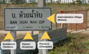
We have 2 format standards for city names in Thailand. One standard for Metropolitan Bangkok and another for the rest of the country (up-country). This is due to the large density of Bangkok and to prevent the map from being cluttered.
Up-Country City Name Standard - Bilingual
The standard city name format to be applied country-wide (except in Metropolitan Bangkok) is to include both English and Thai script in the names: "Tambon (English) Tambon (Thai) - Amphoe (Changwat)". For example: “Bang Sai Yai ตำบล บางทรายใหญ่ - Mueang Mukdahan (Mukdahan)”.
Note: There must be a space before and after the Thai script. If the properly formatted city name is not already added on WME, please request it to be added by a member of the Thailand CM team.
Bangkok Metropolitan City Name Standard - Bilingual
To prevent the map from being over-cluttered with city names, the following standard is applied to all city names in the Metropolitan Bangkok region: “Khet Name (English) Khet Name (Thai), Bangkok”. For example: “Prawet ประเวศ, Bangkok”.
Note: There must be a space between the English text and the Thai script.
Note: Every segment within the boundaries of the city should be named, except for small lakes/ponds, railroad segments, and rivers.
When in doubt, leave the city field blank by checking the "None" box.
Useful WME Scripts and Resources for City Names
WME Color Highlights: This script allows you to highlight every segment and place within a city to check the naming consistency.
https://greasyfork.org/en/scripts/3206-wme-color-highlights
Google Maps: Google maps can be used to “verify” the city borders. Note: The use of information from Google Maps (street names, city names, place names, etc.) is NOT allowed under any circumstances. Failure to comply with this rule will result in your editing rights being revoked.
If you need help using any of the scripts, or have any questions about acceptable external sources of information, please reach out to others in the community and ask for help.
City Smudging
City smudging is caused when road segments are given a city name that lies far beyond the actual borders of the town or city. This is mostly caused by the editor using the city name that displays on the top left of the WME screen, which is not correct a lot of the time. To ensure accuracy, Editors should always base the city names on the actual boundaries of the city and disregard the city name displayed on the WME screen.
Here is an example of a smudged city on the Thailand map:

Here is an example of well-defined cities:

ALL road segments that cross city boundaries should be split at the correct boundary to prevent smudging.
Attention needs to be taken when naming Places to make sure the correct city names are used as well.
For more details on city smudging and how to resolve/remove them, see Smudged Cities
Roads
- Thailand is a left hand traffic country. Cars drive on the left.
- Some satellite photos have shifted over time and with satellite view updates (in the wrong place) or out of date. When encountering areas that have shifted, please take the time to realign the segments to the center of the roadway on the satellite view. Please use care and make sure your editing at least at a Level 8 zoom when adding or realigning road segments. For new roads that are not updated on the satellite view of WME, please use the WME GPS layer to make sure the roads are in the correct place. They can be updated and realigned again once the satellite views are updated.
- Only the satellite and street views available from within WME may be used when editing the map. Local knowledge may be used. External sources of information may not be used. Failure to comply with this rule will result in your editing rights being revoked.
General information on wikipedia, and road signs for those parts that have Streetview.
Street Names (English)
The street names in WME MUST match the official local signage. If there are no official signs indicating the street name, the name is to be left empty by checking the “none” box on the WME street name. This assures the instructions given in Waze match what drivers are seeing to avoid confusion that might lead to an accident or missed turn.
The following naming rules should be applied to all street names:
- Trok or Thanon should be removed from the street name and Rd added to the end of the name. Do not put a . after Rd.
Example: "Thanon Rama 9" in Bangkok should be named "Rama 9 Rd".
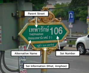
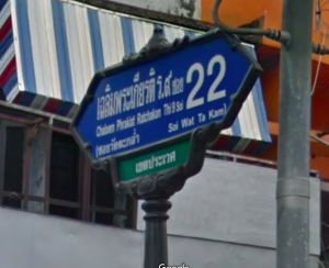
- “Soi” should only be added to the named street if the visible street signs include the word. Do not add Rd or Alley to the end of the name. Soi's are side-streets off of the main roads. Please use the same name that is exactly shown on the sign the Wazers will see. When naming the soi’s you should use the following format:
<Parent Street Name> <Soi 'if present'> <Number>
- Example from the picture: Soi 106 of Thepharak Rd would be entered as Thepharak 106
- Example from the picture: Soi 22 of Chaloem Phrakiat Ratchakan Thi 9 would be entered as Chaloem Phrakiat Ratchakan Thi 9 Soi 22 because 'Soi' is present in the sign
In some cases, Soi's will have a second name which does not reference the major street or the soi number. These should be added as an alt name.
Example: Thepharak 106 is also known as Soi Thephaniwet 2. So we should add the alternative name of "Soi Thephaniwet 2" to these segments.
If local signage references the soi name and not the number, it is ok to use the name as the primary street name, and the number as the alt.
Leave the street name empty by checking the “none” box for the street name if there are no visible signs with the street name for the drivers to see.
The name of the road in Thai script can be added as an alternate name, if known and the editor is able to confirm the accuracy of the text.
You can always "add the alternate name" to give a road more than one name. Use this when a road name has multiple ways to spell it. The Primary Name MUST always match the actual signs the drivers see.
Highways
All highways in Thailand are numbered. The number of digits in the number indicates the role for that section of roadway and can be used to help match the classifications used in Waze. There are a few exceptions.
Naming
We MUST match the naming of highways to the signs drivers are most likely to encounter. The general naming rule is to name the road Hwy followed by the number of the highway (Ex. Hwy 4029). In some areas, these highways may also have a local road name. If you know this name and are confident of where the use of the name starts and ends, you may add it in parentheses “()” after the road number. If you are unsure, leave the road name out, or add it as an alt name. For example: “Hwy 3344 (Srinagarindra Rd)”.
Many highways also have a secondary number as part of the Asian Highway Network. These numbers can be added as an alt name when known. Do not include the Asian Highway number in the primary name.
Motorways & Expressways
Motorways have both names and numbers, while Expressways only have names. Name Expressways as they are officially called. Motorways should be entered as their Route number followed by their name (if they have one).
Example: “Route 7, Bangkok - Chonburi Motorway”, “Route 9, Bangkok Outer-Ring Rd (East)”, and “Si Rat Expressway”.
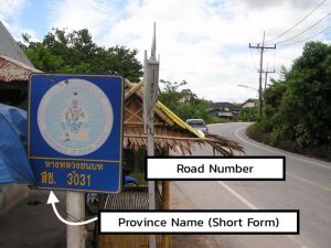
Rural Roads
Rural Roads are highways managed by the local province (ChangWat). They follow the same naming conventions as federally managed highways, except with the inclusion of a two-character prefix indicating the province that maintains them. These follow the same naming and classification as a federal highway, however, we replace "Hwy" with "Rural Rd" before the number. In March 2018 we decided to include the province abbreviation from this Changwat List .
Example: "Rural Rd ปท 3022", where the two Thai characters is the abbreviation of the province. Please note that many Rural Roads continue through more than one province and care should be taken to ensure the correct province abbreviation is used based on the actual location on the map.
| # of Digits | Waze Class | Completed Lock | Naming Example |
|---|---|---|---|
| 1 | Freeway | L5 | Hwy 1 (Phahonyothin Rd) |
| 2 | Freeway | L5 | Hwy 36 |
| 3 | Major Highway | L4 | Hwy 305 Hwy 407 (Kanchana Wanit Rd) |
| 4&5 | Minor Highway | L3 | Rural Rd รย 4027 Hwy 2085 (Poonnakan Rd) |
| Motorway | Freeway | L5 | Route 7, Bangkok - Chonburi Motorway
Route 9, Bangkok Outer-Ring Rd (East) |
| Expressway | Freeway (Toll) | L5 | Si Rat Expressway
Chaloem Maha Nakhon Expressway |
The 'Completed Lock' is the level to lock a road segment once it is completely finished and side roads are stubbed.
Further reading on the Thai highway network.
Note: Long stretches of road outside of cities, that connect many villages and towns, should be set to Minor Highway (mH) type to help with long distance routing, especially if these roads are the primary route to access the towns and villages.
Ramps
Ramp Entrance or Exit segments to or from freeways and highways.
Lock level: The same lock level as the highest lock on the connected freeway or highway segments.
Naming: The names MUST exactly match the signs the drivers see on the road. Follow the Big Green Sign (BGS) or the Big Blue Sign (BBS) (expressways)
Name them by adding "to" before the destinations shown on the BGS or BBS signs. If the exit has an exit number, then add the Exit # before the name instead of using “to”.
Examples:
No Exit #: “to Suvarnabhumi Airport, Passenger Terminal Bldg” and “to Ram Inthra, Bang Na”.
Exit #: “Exit 14: Kaset - Nawamin Rd” and “Exit 1C: Rama 9 Rd”.
Note: Ramps are NOT to be used for U-Turns or with any other type of road. They are only to be used as entrance or exit segments for Freeways and Highways. There are exceptions to this. Please consult with the Thai management before applying any exceptions.
Primary Street
Primary Street Primary Streets are also known as main roads that connect towns or villages together. They are normally 2-4 lanes and include a hard shoulder for emergency use. There are some exceptions. Please consult with the Thai management before applying any exceptions.
Lock Level : L2
Naming: The names MUST exactly match the signs the drivers see on the road and follow the naming format previously outlined.
Examples: “Charoen Nakhon Rd”, “Chan Rd”, and “Sukhumvit 55”.
Street
Street Any Soi and Trok, small and provincial roads which are not main streets.
Lock Level: L1
Naming: The names MUST exactly match the signs the drivers see on the road and follow the naming format previously outlined.
Off-road / Not maintained Road (formerly 4x4 (dirt) Road)
Off-road A road that is physically impossible to drive by a normal car, and should be avoided when possible. For example, a road that goes through a shallow river, badly rutted, or a road that is less than one car wide.
Note: Roads marked as "Off-Road / Not Maintained" will NOT be used for navigation and therefore should NOT be added to the map unless there is a specific benefit in showing it on the map. Please consult with the Thai management before applying any exceptions.
Additional Note: Type Off-road will be used when there’s no other route possible. IF there’s another possible route then Waze will use that even if this means 4 hours extra driving.
Unpaved (Dirt or Gravel) Road
Dirt Roads: Regular streets, without pavement, but for normal use, should be mapped as the type of street that is appropriate (PLR, LS, PS, or mH) and marked "unpaved", so that they can be used for navigation.
Private Road
Private Road A road that goes to a single house, or onto the private property of a gated housing community with controlled access. Only the entrance segment should be set as "private" and locked at L3 to prevent unauthorized changes.
Lock Level: L3
Naming: Naming: The names MUST exactly match the signs the drivers see on the road and follow the naming format previously outlined. If the names are unknown or there are no signs, the names should remain empty (check the “none” box in the street name on WME) but should include the proper city name for its location.
Parking Lot Road
Parking Lot Road Parking lot roads within places such as shopping malls, offices, factories, industrial estates, government complexes, etc. It's not necessary to draw every Parking Lane of a large parking lot. The entrances and exits should be clearly mapped.
Lock Levels: normal parking lots: L1; Gas Station parking lots: L3
Naming: Parking lot roads must NOT be named (check the “none” box in the street name on WME) but should include the proper city name for its location. Please consult with the Thai management before applying any exceptions.
Railroads
|-|-|-|-|-|-|-|-|-| Railroad |-|-|-|-|-|-|-|-|-| Railroad segments are used to show the location of railroads, elevated, at street level, underground (subway), etc.
Lock Level: L5
Naming: The Railroad name MUST match the actual name of the railroad line.
Examples: “BTS Sukhumvit Line”, “MRT Blue Line”, and “Thai Railway”.
Railroad segments should NOT include any city name (check the “none” box in the city name on WME).
Direction: 2-way
Elevation: actual level
Railroad Crossing warning alerts MUST be added to EVERY crossing that physically crosses a road segment at street level.
Walking Trail, Pedestrian Boardwalk, Stairway, Runway / Taxiway, Narrow Street.
Since these types of segments are not used for navigation or incur large penalty times, they should NOT be added to the map in Thailand. Please consult with the Thai management before applying any exceptions.
Note: Narrow Streets are not used as “motorcycle” streets because they will still allow navigation for cars and other vehicles types, albeit with a slight time penalty. In cases where the street is physically impossible for normal vehicle traffic and only allowed for motorcycles, it is best to map them as normal “local street” type and add a restriction to the segments to only allow motorcycles. These types of segments should be locked at L3 to prevent unauthorized or unintended changes. If there is any doubt whether normal vehicles can use the segments, please ask the Thai management team to check the segments before applying the restrictions.
Road markers on StreetView
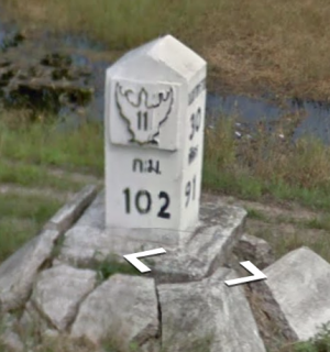
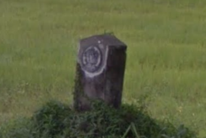
When adding new roads, it is not always easy to find out what type of road to apply. Use the road markers next to the major roads to determine what to apply. They appear every 1 to 2 kilometres for those major roads. Note that the number in/near the bird is the road number. The bottom number is the distance from the start of the road in kilometres. Beware: The markers also function as distance markers. Make sure only to use the info visible on the side that's closest to the road; this is the side showing you the 'bird'.
How to apply the guidelines:
If you find markers with numbers like the following, always classify them as follows:
| Picture | Classification |
|---|---|
 |
Freeway |
 |
Major Highway |
  |
Minor Highway |
If you find road markers without information, classify as Minor Highway when the road provides robust connectivity between 2 major areas and/or major Highways. In order to check this, especially for the oldest roads - you may want to check portions of the route. If they are fully deteriorated, it is unlikely they provide robust connectivity. Classify as Primary Street otherwise.
| Picture | Classification |
|---|---|
 |
Minor Highway. |
 |
Minor Highway. |
If you don't find any markers, Classify as Primary Street when the road unlocks connectivity to one large and/or multiple smaller villages. Otherwise Classify as Street.
| Low Priority Task: if you find a marker in Streetview, please add it to the map. These markers can help us identify specific stretches of Highway. Use a Point Place of type Junction/Interchange; name it Hwy [xx] km [xx] |
Special Road Situations
U-Turns
On Freeways and Highways in Thailand that have divided lanes, there are often designated U-Turn areas created. They can be recognized by both road signs indicating a U-Turn, as well as a U-Turn arrow on the road surface itself.
Sometimes a U-Turn is prohibited for trucks, this is indicated by a text sign under the "U-Turn prohibited" sign.
On smaller roads, there may not be specific signage indicating a U-Turn area, but unless there are specific road signs that prohibit U-Turns, they are generally allowed.
Naming of U-Turns - Bilingual
U-Turns should be named as follows, depending on the type of U-Turn:
- Normal U-Turns = "+ กลับรถ + U-Turn"
- U-Turn Bridge = "+ สะพาน กลับรถ + U-Turn Bridge"
- U-Turn with clearance of 2.5 meter or less = "+ กลับรถ ความสูงไม่เกิน 2.3 เมตร + U-Turn 2.3 Meter Clearance"
Please also include the correct city name for the U-Turn segments.
U-Turn Construction
To ensure proper driving instructions, there are several construction options available. Please see the U-Turn constructions page.
Frontage Roads
A frontage road (also known as an access road, service road, parallel road, etc.) is a local road running parallel to a higher-speed, limited-access road. A frontage road is often used to provide access to private driveways, shops, houses, industries or farms.
Officially both the frontage road and the main roads use the same name. In order to provide the best and most accurate driving instructions, we use the following naming and classification principles in Thailand:
Outside lanes (the frontage roads) are named as "Name_Frontage Rd" and may contain house numbers. The frontage roads are typically classified as Primary Street or Minor Highway depending on the other routing connections that may be connected to the frontage roads.
Examples of frontage road names: “Motorway Frontage Rd”, “Phaholyothin Frontage Rd”, and Rama 9 Frontage Rd”.
Inside (faster, through-traffic) lanes are named with the normal name and format for the street type. The main road is classified at the normal classification for the type of road and should remain consistent throughout.
Examples of main road names: “Route 7, Bangkok - Chonburi Motorway”, “Hwy 1 (Phaholyothin)”, and “Rama 9 Rd”.
If elevated lanes are also present, they are named as "Street name_Elevated", “Street name_Bridge”, or “Street name_Overpass”, or other name, depending on the local naming of each type of elevated road. To maintain routing consistency, the elevated segments are typically classified the same as the main roads they are connected to.
Examples of elevated road names: “On Nut Rd Overpass”, “Rama 9 Sky Rd”, and “Uttaraphimuk Elevated Tollway”.
Please consult with the Thai management before applying any exceptions.
Roads Along a Canal (Khlong Roads)
When a canal (khlong) has a road on each side, they are seen as separate roads. Most are 2-way street but there are some exceptions.
Please check the street view closely when adding new canal roads to make sure they are accurate and reflect the situation drivers will see on the ground. Note that some of the canal roads are different classifications than the other side and care should be taken to classify them correctly to ensure the majority of traffic is sent to the most suitable route.
Dividing Roads
| Dividing existing roads is a low priority task.
This should only be done when drawing in new roads, solving a UR, or as one of the last things you do in your management area before requesting a new one. If you want to divide an existing road, please consult with the Thai management first. |
It should be noted that we are not trying to create a map that copies every visible attribute of each road. We are creating a map that is used to provide “driving directions” to users who are viewing the map via the Waze app on a small device screen. Small divided roads that are close together and those that are not physically divided with an impassable barrier should NOT be divided on the WME map. The turn restrictions can be used to properly manage the flow of traffic for small divided roads without cluttering the map view. It should be noted that dividing small close together roads may result in undesirable driving instructions which can cause confusion possibly resulting in missed turns or causing accidents.
Before dividing any existing road, please consult with the Thai management for advice and direction.

Divide:
Do Not Divide:
See the U-Turn section for instructions on how to properly hand dedicated U-Turn lanes on divided roads.
Turn Instruction Overrides (TIO's)
The majority of connections on the map can be edited with the correct junction angles to provide the correct TTS instructions therefore the use of TIO’s on the WME map should be rare.
The use of the “WME Junction Angle Info” (JAI) script is deemed mandatory for editors in Thailand. If you are not using it, please install it now.
WME Junction Angle Info (link)
There are some rare cases that cannot be addressed with junction angles. In these special cases, TIO’s can be used to provide the desired TTS instructions to the drivers.
Please check the Turn Instruction Override (TIO) page for Thailand specific guidance on the use of TIO's.
Please consult the Thai management if you have questions regarding the use of TIO’s.
Places
Follow the general guidelines with the additions below:
Coastline Issues
There are still many parts of the map where (part of) the land appears to be water. This issue shows in the app (client) or Livemap. Ideally, these should be corrected at Waze HQ level but this is a very low priority. You can fix these 'coastline' issues yourself by making an island area place over the inundated land. After creating the island you wait until it's visible on the livemap and tweak the area until it's perfect. Don't name the island but give it a description like "coastline problem". Then ask to lock it at lvl5.
Place Names
The primary name for places should be the romanized (English) version of the name. If you know the name in Thai and can input it, add it as an alt name.
Addresses
Thai addresses contain a lot of information that can not be easily adapted to the default fields found in WME. Do add city and street as usual, but for now, the complete address can go into the description field of the place (if you know it.)
Point vs Place
Thailand differs from the global standard when it comes to using area places vs point places. Due to many streets having no name or signage (both in real life and in Waze), any significant landmark can be entered as an area place to help with visual navigation. These can be temples, schools, government offices, or any visually distinct business. Area places may not be needed in urban or well-signed areas; use your best judgement to decide when an area place is required.
In general, these places should be named whenever possible. A general descriptor such as "School" or "Temple" may be used in rural areas when no name is known to help with visual navigation.
Keep in mind that Waze does not render smaller area places. The exact size limitations have not been defined, but at the time of this writing, it appears areas need to be at least 25m x 35m to be visible in the app. For important landmarks, it may be permissible to draw the area larger than the actual property line to insure visibility in the app.
Natural Features
Natural features that are large enough to render in the app and visible from the road should be added as area places.
Point Places
Point places should only be added to the map when the name of the business is known.
Parking Lot Areas
For parking lots, we now use a combination of Parking Lot Roads and the Parking Lot Area. For guidance on the creation of these areas, please see the Parking Lot Area page
Examples
- A gas station. Do add the Gas Station place and try to give it the correct brand! Common brands logo and names listed here: ThaiGasStations
- A temple. Their names start with "Wat".
- A railway station.
Update Requests (UR’s)
Please visit this link: Waze Global UR in WME to learn the details of UR’s and read the information below which is specific to how we handle UR’s in Thailand.
When a Wazer using the app submits a map issue to report an error (General Error, Turn Not Allowed, Incorrect Junction, Incorrect Address, Speed Limit Issue, Wrong Driving Directions, Missing Exit, or Missing Road) a yellow update request icon is added to the WME in the Update Requests layer to alert the editors of the problem.
Depending on the Wazers privacy settings on their app, you may or may not be able to see the driver trace and/or the Waze suggested route. It is also possible for them to provide more details of the problem they are reporting, although most do not and we have to investigate the area to see if we are able to determine what problem they encountered. Sometimes the problem is obvious, most times it is not and we have to attempt to make contact with the reporter to obtain more information.
Responding and Resolving Update Requests (UR’s)
UR’s are extremely important and are our opportunity to truly differentiate Waze from any other GPS option available. Therefore, we should give priority attention to any UR’s and attempt to address the problem as fast and accurately as possible.
As you are aware, the map tiles update almost daily and any improvements we make to the map based on UR’s will be seen live on the Waze app within 2-3 days most of the time.
Fast, professional and effective communication, and resolution of the UR creates satisfied Wazers and will help us grow our user base, which in turn will help us grow our Editor Community.
If more information is required to identify the problem, and in most cases, it is, we should send a professionally written request for more information. Bilingual messages are likely the most effective since we do not know the language of the reporter.
If a response is not received, we should be proactive in our follow-up and remind the Wazer that we need more information.
Editor Etiquette Handling UR’s
To maintain consistent and clear communication with the Wazers (UR reporters), it is highly desirable for the Editor making initial contact on a UR to be the same one to follow it all the way through to resolution and/or closure. This will also prevent any potential conflicts within the editor community.
A highly recommended script for monitoring UR’s is UROverview Plus (URO+): UROverview Plus (URO+) script
This script allows you to monitor the UR’s and follow up within the standard timeframes. If you need help using this script, please ask a senior member of the community for assistance.
Recommended Timeline for Communicating on UR’s
1. 1st contact: As soon as possible once the UR icon appears on WME.
2. 2nd contact: If the reporter does not respond to the initial contact attempt, we should wait for 5-6 days and then send a reminder. The reason for the 5-6 day waiting period is to allow the reporter time to respond since they may be busy with other tasks and plan to respond when they have time. We also don’t want to appear pushy or aggressive.
3. 3rd and Final contact: For the same reason as the 2nd contact, we should wait 5-6 days after the 2nd contact to inform the reporter that the UR is being closed due to lack of further information. We should also request them to open a new report if they encounter the error again and provide more information.
Below are some examples of how to respond to UR’s. You are free to change them to suit the individual UR or your own style. Just remember to keep the communication professional and always end the messages with your username and community role, if applicable. Please also include invitations for them to join the editor community on SLACK and to visit our Facebook page.
Examples of UR Dialogue
Example of an initial response:
Hello Wazer,
Thanks for reporting this error.
Unfortunately, I don’t have enough information to repair the problem.
Please give us more information to help us determine what went wrong, like destination, traffic situation at the time of reporting, road closures, etc.?
Please reply to the messages on the Waze App. The email account does not accept replies.
Thank you!
ขอบคุณสำหรับการรายงานข้อผิดพลาดของแผนที่
แต่น่าเสียดายที่เรามีข้อมูลไม่เพียงพอที่จะแก้ไข
โปรดให้ข้อมูลเพิ่มเติมผ่านทางWaze Appเพื่อช่วยเหลื่อการแก้ไขให้ดียื่งขึ้น
(ไม่สามารถรับข้อมูลผ่านทางอีเมล์ได้)
ขอบคุณครับ
If you want to know more about editing the map, please join our community https://join.slack.com/t/wazethailand/shared_invite/zt-edio4mhi-~nhkMIxHrx3UNj61WQNuPg
You can also find us on Facebook at: https://www.facebook.com/WazeThai/
Best Regards,
Editor Name
Community Role – Thailand
Example of 2nd Contact (follow-up):
Hello Wazer,
We really need your additional information to solve the problem. Without your further response, we will have to close this report in a few days.
แจ้งปัญหาเป็นภาษาไทยได้นะ
โปรดให้ข้อมูลเพิ่มเติมผ่านทางWaze Appเพื่อช่วยเหลื่อการแก้ไขให้ดียื่งขึ้น
(ไม่สามารถรับข้อมูลผ่านทางอีเมล์ได้)
Please reply to the messages on the Waze App. The email account does not accept replies.
Thank you!
If you want to know more about editing the map, please join our community https://join.slack.com/t/wazethailand/shared_invite/zt-edio4mhi-~nhkMIxHrx3UNj61WQNuPg
You can also find us on Facebook at: https://www.facebook.com/WazeThai/
Best Regards,
Editor Name
Community Role – Thailand
Example of 3rd and Final Contact:
Hello Wazer,
This report is being closed due to no feedback from the reporter. If you encounter further problems in this area, please open a new report and provide more information to allow us to correct the problem.
If you want to know more about editing the map, please join our community https://join.slack.com/t/wazethailand/shared_invite/zt-edio4mhi-~nhkMIxHrx3UNj61WQNuPg
You can also find us on Facebook at: https://www.facebook.com/WazeThai/
Best Regards,
Editor Name
Community Role – Thailand
Additionally, if you are able to identify the exact cause of the error and correct it on the map, please provide a response to the reporter explaining what changes you made to address the problem and thanking them for helping to improve the map.
Example:
Hello Wazer,
Thanks for reporting this error.
I have added several missing roads in the area of your report. Please allow 2-3 days for the changes to be active on the Waze App.
If you find more errors, please open a new report and provide as much information as possible to allow us to fix the problem. Thank you for helping to improve the map.
If you want to know more about editing the map, please join our community.
https://join.slack.com/t/wazethailand/shared_invite/zt-edio4mhi-~nhkMIxHrx3UNj61WQNuPg
You can also find us on Facebook at: https://www.facebook.com/WazeThai/
Best Regards,
Editor Name
Community Role – Thailand
Levels, rights, etc
If you can't edit something because it is locked, ask here. Before you start working on an intersection or roundabout, don't forget to check all the levels of the connecting segments, to make sure you can finish the job!
In areas that are mostly under construction, locks are not required and everyone is encouraged to help.
If you insist on locking roads in an unfinished area, try stubbing. Stubbing is making a short low-level segment for each exit that a low-level editor can attach to.
You can become area manager by filling out this form: AM Application Form. You will then also be invited to join the Thailand channel at Waze Slack.
Current Management
sstuff3 (Scott) (Country Coordinator), Dutchdirt (Peter), Orbit, Shmupi, HandOfMadness (Shawn),
Sorin100, machete808, fermario73, Nacron, RIMAJUES, nttee
