Szybka Nawigacja do...
| Edytowanie | |
| Poradnik edytowania | Updated Editing Guidelines ● Edycja Map - szybki start |
| Edytor Map Waze | Zastrzeżone funkcje edytora map ● Ochrona mapy ● Interfejs i kontrolki Edytora Map |
| Drogi | Kategorie dróg w Polsce ● Tworzenie i edycja segmentów dróg |
| Ograniczenia prędkości | Przewodnik po ograniczeniach prędkości ● |
| Nazewnictwo | Wzorce nazywania dróg ● Nazywanie ulic ● Tabela skrótów ● Miejscowości o takich samych nazwach |
| Pierwsze kroki w edytowaniu | Najlepsze Praktyki ● Editing Basics ● Editing Bridges and Tunnels |
| Połączenia | Skrzyżowania ● Ronda ● Niepotwierdzone i potwierdzone skręty |
| Problemy i Błędy | Zgłoszenia użytkowników (UR) ● Problemy mapy (MP) |
| Wszystko o Miejscach | Przewodnik po miejscach ● Standaryzacja nazw ● Zgłoszenia aktualizacji miejsc (PUR) ● Miejsca wjazdu/wyjazdu |
| Ograniczenia i blokady | Planowe ograniczenia w ruchu ● Zamknięcia w czasie rzeczywistym |
| Routing i Nawigacja | Oblicznie trasy ● Navigation Instructions |
| Wydarzenia | MapRaid ● WoW |
| Ten artykuł lub sekcja jest nieprzetłumaczony. Możesz pomóc Wazeopedii Polska przetłumaczyć go. |

Zamknięcie w czasie rzeczywistym to preferowana metoda tymczasowego zamykania dróg, ponieważ jest widoczna natychmiastowo dla Wazerów i ponieważ pomaga chronić mapę.
Podejmowanie decyzji o użyciu RTC
Istnieje kilka sposobów blokowania ruchu przez segment. Najlepszy wybór zależy od sytuacji.
| Metoda | Pojazdy | Rozpoczęcie | Koniec | Dane o ruchu | Informacje |
|---|---|---|---|---|---|
| Zamknięcie w czasie rzeczywistym | Wszystkie | Natychmiastowe | Wygasa | Zachowane | Preferowana opcja tymczasowego (nawet długoterminowego) zamknięcia w jedną stronę lub w obie strony. Natychmiast widoczne dla kierowców. Automatycznie usuwany po wygaśnięciu. |
| Zmiana kierunku drogi | Wszystkie | Aktualizacja mapy | Stała | Zachowane | Używaj tylko do stałej zmiany kierunku z dwukierunkowej na jednokierunkową. |
| Planowane ograniczenia segmentu | Wybrane | Aktualizacja mapy | Wygasa w zależności od opcji | Zachowane | Stosuj tylko wtedy, gdy ograniczenia (pora dnia / dnia tygodnia) są stałe lub gdy niektóre typy pojazdów są dozwolone lub zabronione. Przykład: Brak samochodów osobowych w dni powszednie. |
| Planowane ograniczenia skrętu | Wybrane | Aktualizacja mapy | Wygasa w zależności od opcji | Zachowane | Stosuj, gdy ruch na segmencie jest dozwolony, ale skręty są tymczasowo zabronione lub trwale zabronione o określonych porach dnia, w dni tygodnia lub w przypadku niektórych typów pojazdów. Przykład: brak skrętu w lewo 16:00 - 18:00 |
| Stałe ograniczenie skrętu | Wszystkie | Aktualizacja mapy | Stałe | Zachowane | |
| Zmiana na inny typ segmenu z większą karą routingu | Wszystkie | Aktualizacja mapy | Stałe | Zachowane | Kary zmniejszają prawdopodobieństwo routingu, ale nie są bezwzględne. Pojazdy z miejscem docelowym w segmencie zostaną skierowane na segment. Zwykle używana jest Droga prywatna . |
| Odłączenie | Wszystkie | Aktualizacja mapy | Stałe | Stracone | Używaj tylko wtedy, gdy rozłączenie jest trwałe. Wszystkie dane o ruchu zostaną utracone. |
| Usunięcie | Wszystkie | Aktualizacja mapy | Stałe | Stracone | Używaj tylko wtedy, gdy droga jest trwale zamknięta. Wszystkie dane o ruchu zostaną utracone. |

- Zaczynają wpływać na routing w ciągu kilku minut od zapisania, bez oczekiwania na aktualizację mapy.
- Po usunięciu RTC routing jest przywracany natychmiastowo, bez oczekiwania na aktualizację mapy.
- Pozwalają edytorom tymczasowo blokować routing po określonych segmentach, bez konieczności wprowadzania zmian tych segmentów.
- Zachowują dane o ruchu.
- Domyślnie (patrz poniżej) droga zamknięta za pomocą RTC będzie stale monitorowana pod kątem ruchu. Jeśli wykryty zostanie ruch o wystarczającym matężeniu odbywający się przez zamknięcie, zamknięcie zostanie tymczasowo dezaktywowane, dopóki nie zostanie ponownie wykryte brak ruchu. Dlatego jeśli RTC zostanie omyłkowo umieszczony na otwartym segmencie, wpłynie to tylko na kierowców przez kilka pierwszych minut, dopóki nie zostanie wykryty ruch przelotowy i zamknięcie zostanie automatycznie wyłączone.
- Zamknięcia w czasie rzeczywistym są widoczne w mapie na żywo i aplikacji Waze ze specjalnymi ikonami alertów i podświetlaniem segmentów. Są one również widoczne w WME ze specjalnymi ikonami.
- Można je tworzyć i komentować z poziomu aplikacji Waze. Powiadomienia o takich zamknięciach zostaną wysłane do edytowów WME z pomocą [[WazeMożna je powiązać z Ważnymi Wydażeniami Drogowymi. Dzięki temu pobliscy użytkownicy Waze otrzymają powiadomienia o nich.
- Eliminują potrzebę dodawania i usuwania częściowych ograniczeń. W rzeczywistości częściowe ograniczenia nie powinny być stosowane redundantnie do zamknięć w czasie rzeczywistym
Wpływ na routing

Jeśli Wazer znajduje się na zamkniętym odcinku, Waze znajdzie trasę rozpoczynającą się w zamkniętym odcinku i znajdzie najkrótszą trasę do odcinka bez zamknięcia.
Jak dodaje się do mapy zamknięcia w czasie rzeczywistym
Zamknięcia w czasie rzeczywistym (RTC) mogą zostać dodane do Waze na trzy sposoby:
Zamknięcia w czasie rzeczywistym w WME
Jak dodać zamknięcie w czasie rzeczywistym

- Zapisz wszystkie oczekujące zmiany. Nie będzie można dodać ani edytować zamknięć, jeśli istnieją oczekujące zmiany. Pamiętaj, że zapisanie edycji, która zmienia numer segmentu, uniemożliwi dodanie RTC.
- Wybierz segmenty, które chcesz zamknąć.
- Kliknij zakładkę Zamknięcia w lewym panelu.
- Kliknij - Dodaj zamknięcie i wypełnij wszystkie pola:
- OPIS- Ta sekcja będzie widoczna zarówno w aplikacji klienckiej, jak i na mapie na żywo. Wpisz tutaj opis zamknięcia/wydarzenia.
- KIERUNEK - Jeśli zostanie wybrany pojedynczy segment jednokierunkowy, właściwy kierunek zostanie automatycznie wybrany. Jeśli segment jest dwukierunkowy, a zamknięcie odbywa się tylko w jednym z kierunków, wybierz ten kierunek tutaj. Jeśli wybrano wiele kierunków, edytor powinien wybrać dwukierunkowe zamknięcie, a następnie wszystkie dwukierunkowe segmenty zostaną zamknięte w obu kierunkach, a segment jednokierunkowy zostanie zamkniety w jednym kierunku.
- WYDARZENIE - Jeśli to zamknięcie jest częścią Ważnego Wydażenia Drogowego (MTE), wybierz je z listy. Jeśli nie jest częścią żadnego, wybierz None lub dodaj takie wydarzenie.
- START/KONIEC - Wprowadź datę i godzinę, kiedy zamknięcie się rozpocznie (data początkowa może być datą z przeszłości). Wprowadź prawidłową godzinę zamknięcia dla lokalnej strefy czasowej zamykanego segmentu, niezależnie od tego, gdzie się znajdujesz podczas wchodzenia w zamknięcia. Czas jest wprowadzany w formacie 24 godzinnym a daty w formacie RRRR-MM-DD. Pierwsza minuta dnia rozpoczyna się o 00:00, a ostatnia o 23:59.
- Data końcowa nie może przypadać później niż 183 dni po dacie początkowej i nie dłużej niż rok po bieżącej dacie.
- Zamknięcia w czasie rzeczywistym są aktywne przez całą minutę, dla której zostały ustawione (do 00 sekund następnej minuty).
- Nie używaj 24:00 jako godziny rozpoczęcia lub zakończenia.
- 00:00 to pierwsza minuta dnia. Unikaj używania jejejgo jako czasu rozpoczęcia.
- Zamknięcie z danymi Start: 03:00, Koniec: 04:00, właściwie będzie działać przez 60 minut i 59 sekundy, od 03:00:00 do 04:00:59.
- Najdłuższy czas zamknięcia możliwy do ustawienia to 183 dni.
- W przypadku ustawiania zamknięcia na 365-dni, wprowadź zamknięcie na 183 dni, a następnie zamknięcie na 182 dni.
- Zapisz i sprawdź
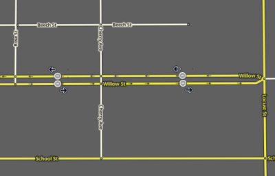
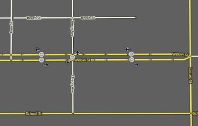
- W WME zamknięte segmenty zostaną oznaczone ikonami zamknieć z czarnymi strzałkami zamknietego kierunku
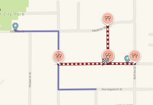
- Na Mapie Live aktywne zamknięcia będą wyświetlane z czerwonymi ikonami zamknięcia, a zamkniete segmenty będą wyświetlane na czerwono-biało.
- By zobaczyć wszystkie zamkniecia na Mapie Live konieczna może być zmiana przybliżenia mapy.
- Jeżeli zamknięcia są powiązane z wydarzeniem można je podejrzec w trybie wydarzeń.
- Nieaktywne zamkniecia nie bedą wyświetlane na Mapie Live i bedą tylko wyświetlane w WME z szarymi ikonami zamkniec.
Cross streets - which segments to close
Closing several segments of a road will prevent Waze from routing wazers down that road. But it will not prevent Waze from routing wazers across the road at the intersections. Often in work zones and for special events (parades, marathons, festivals), cross traffic should not be allowed at some or all of the junctions. If traffic going across your Real-Time Closure must be blocked at a junction, you will need to close at least one of the cross street segments as well. Waze will not route up into a closed segment to reach a destination within it, but it will route out of the "most convenient end" of a closed segment if the user starts within it. So if you need to allow wazers to reach destinations less than a block from the closed road, close the cross street segments in the direction moving away from the closed road.
- Regular cross-streets
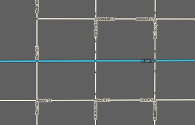
- Close two-way cross-street segments on both sides of the closed intersection. Each segment should be closed in the direction traveling away from the closed junction. Closing all outbound segments routing from the intersection will prevent routing across the intersection's junction node to reach a destination or leave a starting point, regardless of the user's position in relation to that junction node.
- If traffic at an intersection is being directed by police, then it is not necessary to apply a closure at the cross street. Waze will detect the traffic slowdown and route accordingly.
- Close one-way cross-street segments on the side traveling away from the closed junction. Closing the "way out" from the junction prevents Waze routing wazers through the junction.
- Median segments of closed divided roadways
- When both directions of a divided roadway are closed and cross traffic is disallowed, consider closing only the median segment. This is enough to prevent cross-traffic routing from either side.
Illustrations and examples
How we learn about closures
The editing community can be informed about these closures by:
- URs/MPs submitted through the app
- Knowledge of local happenings
- Notification from the local community / Waze Major Traffic Event Team
- Long-term closures
All Real-Time Closures follow the same general principles below, regardless of which method is used to submit them. Depending on which method is used there are additional guidance and instructions in the corresponding unique subsections below.
Connected Citizens Program
Through the Connected Citizens Program, Waze shares and receives information from select entities which partner with Waze. This information can include Road Closures which are entered in WME directly by Waze Staff or the CCP's employees. Wazers are encouraged to promote these relationships with their local governing entities.
Closure guidance and tips
Usernames and closures

Closure feature permissions
- Usual situation
- Rank: Your rank must be Szablon:Rank or above.
- Edit permission The segment must be in your editing area, and be locked at or below your rank
- RTC area - a special-purpose area granted by your RC for the purpose of making closures. Generally granted to CCP partners
- You can apply a closure to any segment within the RTC area, no matter the lock level.
If you are unable to close a segment, then contact an editor who can via PM, in WME Chat, or in Discord. Some regions of the US use a closure form to submit closure requests. Please check with your local community.
Closing recently edited segments
Road closures are not subject to waiting for a tile update; they will go live almost immediately. However, they only work on segments that have already been uploaded to the map. You will not be able to save a closure on any segment that was cut, merged or newly drawn after the last tile update, because the new segment ID will not be recognized. WME will display the error message (!) Failed to add road closure -xxx. Wait until after the changes are included in a tile build, then enter the closure again and it will save.
For this reason, if you need to remove a segment or cut a segment in two that should not currently be routed, first place a time-based segment restriction on the segment, then apply the closure. After the next tile update, the segment restrictions will be in place at least until the next tile update. You can then remove the closure and make the types of changes that will prevent applying the closure. After one more tile update, you should be able to remove the time-based segment restriction (TBSR) and reapply the closure. This should allow you (after 2 or 3 days) to limit a closure to a damaged bridge rather than being forced to apply it to a mile-long segment of road, for example.
Also, certain edits like disconnection or creation of a roundabout on existing segments affect one's ability to add closures, even though they do not change the segment ID. After disconnecting a segment from another or drawing a roundabout onto it, you will only be able to save a closure on the existing segment that ends less than 48 hours in the future. If you extend it further, WME will display the error message (!) The highlighted segment has been modified recently and will be rebuilt. You will not immediately be able to add a closure on the new roundabout segments themselves. After a tile update, this time limitation is removed, and a longer closure can be created on the existing segments that go into or out of the roundabout, or on the new roundabout segments. This is useful for maintaining closures while drawing roundabouts at existing intersections
Edycja segmentów z zamknięciami
NOTE: If a segment has a closure on it in WME, it cannot be directly modified by any editors - regardless of rank. This is by design, to prevent any changes to segment IDs which will corrupt the closure. Turns and house numbers associated with the segment can be edited normally.
If you need to edit the segment, you will have to first remove the closure (copy the details first), then modify the segment and save. If the edit did not alter the segment or junction node IDs, you can immediately replace the closure with the details you copied to the appropriate segments. If you altered any segment or junction node IDs, you will have to wait until after the next tile update before reentering the closure.
Closing multiple segments
Road closures can be added to multiple segments simultaneously by selecting all the affected segments first. Be careful to verify all the segments after you save that the closuress were added properly. It's been reported before when multiple closures were added at once, that some of the segments either weren't closed, or had incorrect details in the closure (e.g. direction).
Segment direction for one-way closures
If only some of the segments are one-way, or some one-way segments are in opposing direction (B-A, A-B), you can set the closure as two-way for all the segments. When you save you will see an error line for each direction of a closed segment which failed to save because the segment is one-way. You can ignore the error, and all your segments should be closed in all possible directions. (Be sure to double check them all.)
Ważne Wydażenia Drogowe (MTEs)
There are two ways to create Major Traffic Events in Waze.
- The easiest way, for editors of rank Szablon:Rank and higher, is to create the event and the closures in the Waze Map Editor. See the full article for more details on creating a Major Traffic Event in the WME.
- Editors below rank Szablon:Rank can reach out to their local community who will be glad to assist them in generating the MTE, and associated closures in the WME.
- Non-editors can still submit information directly to Waze Closure staff (see below) to create an MTE, and (optionally) get a message out to wazers in the area.
Submitting directly to Waze
To submit a major traffic event, email waze-closures@google.com with the following details:
- The event name in English and in the Local Language
- All street names closed during the event
- Intersecting street where each closure begins and ends
- Start and end time for each closed road
- Start and end date for each closed road
- Indicate if the whole road is closed or just one direction is closed
Some pointers when submitting events directly to Waze Closure staff:
- Check your email; find out who will be working with you on these closures, when they are available to upload closures. Make sure you have time to double-check closures before the event begins.
- Waze staff might not publish the MTE to their [www.waze.com/events Events] page, until shortly before the event. Make sure to communicate with them so you can verify the details.
- Closures will go live as soon as they are uploaded (within their specified time frames).
- Closure Sheets are obsolete, and are no longer used to input Real Time Closures, or to generate an MTE.
Raport o zamknięciu w aplikacji Waze
Użytkownicy aplikacji mobilnej mogą oznaczyć zamkniętą drogę, którą widzą podczas jazdy. Instrukcje dotyczące korzystania z tej funkcji w aplikacji Waze są dostępne w Waze Help Center.
- Ta funkcja jest zwykle używana w przypadku nieoczekiwanych, krótkoterminowych zamknięć trwających do kilku dni..
- Zgłoszone zamknięcie natychmiast pojawi się w aplikacji użytkownika zgłaszającego.
- Zasadniczo zamknięcie nie pojawi się dla nikogo innego, dopóki kilku innych użytkowników nie zgłosi tego samego zamknięcia.
- Edytorom mogą zostać nadane uprawnienia zgłaszania zamknięć, które w aplikacji będą pojawiac się przy mniejszej liczbie potwierdzeń przez innych użytkowników.
- Jeśli edytor ma rangę 5 lub wyższą, jego zamknięcie w aplikacji wejdzie w życie natychmiast.
Zamknięcie z aplikacji Waze w WME
Zamknięcia w aplikacji są również widoczne z poziomu WME
- Data rozpoczęcia to 1969 lub 1970
- Zamknięcia te można usunąć lub edytować powyżej rangi edytora 3
- Jeśli w segmencie znajduje się wiele RTC zgłoszonych przez aplikację, zostanie wygenerowany błąd podczas próby edycji i zapisania zmian w jednym z nich. Najpierw usuń zduplikowane wpisy, a następnie wprowadź zmiany w pozostałym wpisie.


