Nie podano opisu zmian |
Nie podano opisu zmian |
||
| Linia 6: | Linia 6: | ||
=={{anchor|Length issues}}Determine the length== | =={{anchor|Length issues}}Determine the length== | ||
Długość segmentu można określić po jego utworzeniu i zapisaniu, wybierając go i patrząc na kartę ogólną z wybranym segmentem. Długość będzie wyświetlana w dolnej części zakładki w meterach lub kilometrach (urzywając [[Interfejs i kontrolki Edytora Map|jednostek metrycznych w WME]]). Długość segmentu nie pojawia się przed jego zapisaniem. | Długość segmentu można określić po jego utworzeniu i zapisaniu, wybierając go i patrząc na kartę ogólną z wybranym segmentem. Długość będzie wyświetlana w dolnej części zakładki w meterach lub kilometrach (urzywając [[Interfejs i kontrolki Edytora Map|jednostek metrycznych w WME]]) lub i milach (urzywając [[Interfejs i kontrolki Edytora Map|jednostek imperialnych w WME]]) . Długość segmentu nie pojawia się przed jego zapisaniem. | ||
{{mbox | {{mbox | ||
| type = info | | type = info | ||
Aktualna wersja na dzień 14:44, 5 lis 2019
Szybka Nawigacja do...
| Edytowanie | |
| Poradnik edytowania | Updated Editing Guidelines ● Edycja Map - szybki start |
| Edytor Map Waze | Zastrzeżone funkcje edytora map ● Ochrona mapy ● Interfejs i kontrolki Edytora Map |
| Drogi | Kategorie dróg w Polsce ● Tworzenie i edycja segmentów dróg |
| Ograniczenia prędkości | Przewodnik po ograniczeniach prędkości ● |
| Nazewnictwo | Wzorce nazywania dróg ● Nazywanie ulic ● Tabela skrótów ● Miejscowości o takich samych nazwach |
| Pierwsze kroki w edytowaniu | Najlepsze Praktyki ● Editing Basics ● Editing Bridges and Tunnels |
| Połączenia | Skrzyżowania ● Ronda ● Niepotwierdzone i potwierdzone skręty |
| Problemy i Błędy | Zgłoszenia użytkowników (UR) ● Problemy mapy (MP) |
| Wszystko o Miejscach | Przewodnik po miejscach ● Standaryzacja nazw ● Zgłoszenia aktualizacji miejsc (PUR) ● Miejsca wjazdu/wyjazdu |
| Ograniczenia i blokady | Planowe ograniczenia w ruchu ● Zamknięcia w czasie rzeczywistym |
| Routing i Nawigacja | Oblicznie trasy ● Navigation Instructions |
| Wydarzenia | MapRaid ● WoW |
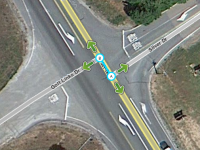
Podczas tworzenia segmentu ważne jest, aby każdy indywidualny segment miał co najmniej 5 m. Mniej ważne jest stosowanie określonej długości, ale istnieją wady zbyt długich segmentów omówione poniżej.
Determine the length
Długość segmentu można określić po jego utworzeniu i zapisaniu, wybierając go i patrząc na kartę ogólną z wybranym segmentem. Długość będzie wyświetlana w dolnej części zakładki w meterach lub kilometrach (urzywając jednostek metrycznych w WME) lub i milach (urzywając jednostek imperialnych w WME) . Długość segmentu nie pojawia się przed jego zapisaniem.
| The displayed length for both imperial and metric settings is based on a rounded metric number and does not reflect the actual segment length. However, a developer in the Waze editing community has developed a script called WME True Segment Length. This script will display the true length of the segment in both metric and imperial units with two decimal places of accuracy. Unfortunately, that display is not really important since the server only considers the rounded metric values. |
Too short
When a segment is less than 5 m it becomes difficult for the navigation engine to determine traffic speed through that segment. That will in turn negatively affect drive time estimations and best routing.
Between intersections

See the Junction Style Guide section on offset roads for more details about this situation.
Necessary short segments
There are a few instances where a single short segment may be present between two other segments with no other segments at those junctions. Sometimes these junctions are necessary and should not be removed. These include: Necessary junctions
In the above cases, the segment is necessary so it cannot be deleted, but it can be made at least the minimum length and still meet the needs of the original purpose.
Too long
Segments longer than about 62 miles (100 km) cannot be saved. In addition, there are several good reasons to keep segments shorter than 6.2 miles (10 km):
- Long roadways or railroads with the city name present will cause a smudged city issue on the city layer.
- Long segments require more resources in the client and WME to render on the screen.
Fixing long segments
Simply cut the segment to add one or more junction points. Each resulting segment should be shorter than the maximum length and longer than the minimum length.