m (→Editors) |
|||
| (121 intermediate revisions by 15 users not shown) | |||
| Line 1: | Line 1: | ||
{{construction | {{construction | ||
| contact = | | contact = | ||
| contacttype = | | contacttype = | ||
| draft = | | draft = no | ||
| open = no | | open = no | ||
| revision = | | revision = yes | ||
| talk = | | talk = | ||
}} | }} | ||
| Line 12: | Line 12: | ||
Welcome to Waze Pakistan</p></div></center> | Welcome to Waze Pakistan</p></div></center> | ||
You want to help too? Read along and join the [[ | |||
You want to help too? Read along and join the [[Main Page#Community|local community]] of Waze Pakistan.<br /> | |||
<br /> | <br /> | ||
<!-- | <!-- | ||
| Line 31: | Line 30: | ||
==Waze in Pakistan== | ==Waze in Pakistan== | ||
=== Communication === | ===Communication=== | ||
=====Forums===== | |||
[https://www.waze.com/forum/viewforum.php?f=295 Waze Forums] are the <b>{{red|official}}</b> Waze communication platform where you will find a lot of information as an editor. Log into the Waze Pakistan forum using your Waze login and password as you would the editor or app. The forum also has [https://www.waze.com/wiki/index.php/Private_message Private Messages] (PM) where you can send and receive messages to other editors. | |||
=====<span style="color:green">Discord</span>===== | |||
'''WE'VE MOVED FROM SLACK TO DISCORD!''' | |||
While the Waze Forums are the {{red|official}} method of communications for anything Waze, the local editing community has adapted to Discord for its day to day communication amongst the editors. There are teaching classes and webinars to improve your editing skills. There are several channels, project groups, and you can send Direct Messages (DM) too. If you like to join into discussions and development of Waze Pakistan, Discord gives the best opportunities. You can access the [https://discord.gg/ay7zWE2De5 '''Pakistan Discord server here''']. | |||
Waze Forums are the | |||
===== WME Chat ===== | =====WME Chat===== | ||
[[File:WME-Chat-Window-Minimized.png|80px|right]] | [[File:WME-Chat-Window-Minimized.png|80px|right]] | ||
While you are editing, you can directly request help in [https://wazeopedia.waze.com/wiki/Global/Waze_Map_Editor/Chat WME chat]. It shows you the level of the editor you are talking to. Please keep in mind that most editors are willing to help, but not all of them have the technical knowledge or editing experience to give you the best answer. Because the built-in chat does not always work as desired, we mostly use [ | While you are editing, you can directly request help in [https://wazeopedia.waze.com/wiki/Global/Waze_Map_Editor/Chat WME chat]. It shows you the level of the editor you are talking to. Please keep in mind that most editors are willing to help, but not all of them have the technical knowledge or editing experience to give you the best answer. Because the built-in chat does not always work as desired, we mostly use [https://discord.gg/ay7zWE2De5 Discord] to communicate with local community editors. | ||
===== < | ==Community== | ||
===Editors=== | |||
The community consists of all people that uses Waze one way or another. Drivers, editors, wiki master and the like. The current active community management in Pakistan is a mix of local and international editors. For any question or suggestion you can contact them via Waze forums or address one of the champs or project leaders directly from the tables below. | |||
{{AM/Top|Pakistan}} | |||
{{AM/Country}}<!--Country Managers Below--> | |||
{{AM/Editor|marcin_s|6|Poland & Pakistan Country Coordinator|badge1=LC|badge2=M||gho=|pic=}} | |||
{{AM/Editor|Dude495|5|Pakistan Country Coordinator<br>Local Champ||badge1=LC|badge2=CM|badge3=mr|badge4=M||}} | |||
{{AM/Editor|Airchair|5|Pakistan Country Manager|badge1=cm|badge2=m||gho=|pic=}} | |||
{{AM/Editor|jawadch|4|Pakistan Country Manager|badge1=cm||gho=|pic=}} | |||
{{AM/Editor|Z__A|4|Pakistan Country Manager|badge1=cm|badge2=mr||gho=|pic=}} | |||
{{AM/Area}} <!--Area Managers Below--> | |||
<!--Add yourself using the following format {{AM/Editor|Username|Rank|AM Location|Additional Comments|badge1=BADGE1|badge2=BADGE2|badge3=BADGE3|badge4=BADGE4}} Additional info on badges and formats can be found here https://wazeopedia.waze.com/wiki/Pakistan/Template:AM/Area--> | |||
{{AM/Editor|ldriveskier|6|Northern Pakistan<br>USA based Global Champ|badge1=mr|badge2=am||gho=|pic=}} | |||
{{AM/Editor|Challenger3802|5|Southern Pakistan<br>CW South Africa & Sri Lanka|badge1=mr|badge2=am|British|gho=|pic=}} | |||
{{AM/Editor|Chronos74|5|Sindh<br>USA Multi-State Manager|badge1=m|badge2=mr|badge3=am||gho=|pic=}} | |||
{{AM/Editor|j-d-|5|Central Pakistan|badge1=LAM|gho=|pic=}} | |||
{{AM/Editor|V_Dorb|5|Sadiqabad-Rahim Yar Khan-Khan Pur|badge1=am|French|gho=|pic=}} | |||
{{AM/Editor|DeMassel|4|Northern Pakistan |badge1=LAM|badge2=mr|Dutch|gho=|pic=}} | |||
{{AM/Editor|kamonu|4|Northern Pakistan|badge1=am||gho=|pic=}} | |||
{{AM/Editor|Jyaire|3|Islamabad |badge1=LAM|badge2=mr|French|gho=|pic=}} | |||
{{AM/Editor|MoffaCocca|3|Lahore and Islamabad|badge1=am||gho=|pic=}} | |||
{{AM/Editor|NOVAGENOFFICIAL|3|Lahore|badge1=am||gho=|pic=}} | |||
{{AM/Editor|goncalovm76|6|Northern Pakistan|badge1=am||gho=|pic=}} | |||
{{AM/Bottom}} | |||
<small> | |||
* To add yourself, click "Edit Source" on the '''Editors''' section and add yourself in the appropriate section following the format of the other users.</small> | |||
{{AM/Area2Link}}<!--Other Editors exit this page and follow the instructions listed on the main page-->To apply for Area Manager please fill out [https://docs.google.com/forms/d/e/1FAIpQLSddW_wuJmMbXr09BrLBT2iKKqaW5582n1OAFxi-z6LMmApnbA/viewform '''this form''']. | |||
==Cities== | |||
===Naming=== | |||
Unique naming is very important to find a specific address and to improve the end user navigation experience. In Pakistan, we have an additional aspect to consider while naming a city or street which is the dual language system. We are using English as well as Urdu as our language of communication; English is mainly for online tasks whereas Urdu (our National language) is used to communicate among people. The layman (as well as others) is using mainly Roman Urdu (Urdu written with Roman/English alphabets) to communicate while using different communication channels e.g., Mobile SMS, Internet etc. Urdu alphabets are also in use, though it seems difficult to type. One thing is sure that we humans are more comfortable in our native/national language than in English (or any other foreign language) and using Urdu in Naming would increase the outreach of Waze; the end user would see the map in his/her native/national language and would have more tendency to accept it and use it frequently. Hence, language factor must be considered to name a city and street etc. | |||
In Pakistan, we don’t have unique names for each and every street; we have sometimes the street numbers and sometimes names and sometimes we don’t have any name at all for the streets. We are using sectors/ blocks/ community or colony names to find those streets, in our real life. Unfortunately at this time, Waze Map Editor does not support these types of naming configurations. We've asked HQ for additional fields and are awaiting the implementation. Please {{red|DO NOT add Sector/Block/Community/Colony names as City names or in street names}}. Instead of adding "hacks" to get a result we want, let's wait until the features we ask for are added. This helps prevent us from having to do the work all over again to fix these hacks once the features are available. | |||
Pakistan Team has discussed the naming system for <b>cities</b> to be used and have determined to use Romain Urdu and Urdu names as the primary names. | |||
Examples: | |||
*City Name: Dera Ismail Khan ڈیرہ اسماعیل خان | |||
<br /> | |||
<small><nowiki>*</nowiki> If you do not know the Urdu translation the primary name should be Roman Urdu ("English"). If you cannot verify the Urdu or Roman Urdu name please leave the names marked as "None" and let the local community add the names or reach out to one of the local community members. {{red|Do not use online translators as they are not always accurate}}. Remember you can always navigate across unnamed roads but you cannot navigate without the roads.</small> | |||
==Roads== | |||
===Segment Naming=== | |||
All segments should be named appropriately with their actual name and [[global:Abbreviations_and_acronyms#Standard_suffix_abbreviations|abbreviated suffix]] with the exceptions below. | |||
Motorways should have primary name set as M-#, any other local names should be added as alternative names. This will help with Road Shields being added properly. | |||
All National Highways should have the correct primary street name N-#, any other local names should be added as alternative names. This will help with Road Shields being added properly. | |||
'''Do not name Street segments at all at this time'''. This causes problems with routing and until Waze can give us more options to build these properly these must be left unnamed. Waze will continue to use Google search results for proper routing but will not give TTS on these segments as a side effect. | |||
<br /> | |||
===Incomplete segments or red roads=== | |||
Be sure to select country, state, enter the city name or check "None", and enter a street name, or check "None". Until you do this, your road will not be routable and will not show on the client map. | |||
[[File:Incomplete.jpg|80px|right]] | |||
These incomplete segments are colored bright red in WME. | |||
This must be done on all streets created in WME, and on all streets created with the client "Pave" function. | |||
"Paved" streets must also be connected to their adjacent roads, and turn restrictions must be set in order to be routable. | |||
For more detailed instructions on how to address red roads see: Confirming the road by updating details | |||
===Every loop must be made up of three or more segments=== | |||
[[File:Loop_3-part_6.jpg|right|150px]]Any loop that does not follow this rule can cause problems for the Waze routing server. If there is no side-street, you must [[global:Map_Editing_Quick-start_Guide#Cutting_a_segment|insert an extra junction node]] along the loop. Many new editors will see the extra junction node(s), assume they are not needed, and delete them. This '''[https://youtu.be/zx8kWug5M0c YouTube video]''' shows how to fix a loop that only has two segments. | |||
===Too short=== | |||
When a segment is less than 6m it becomes difficult for the navigation engine to determine traffic speed through that segment. That will in turn negatively affect drive time estimations and best routing. | |||
== | ===Between intersections=== | ||
[[File:Mismatched_Intersection.png|200px|right]]There may be times when driveways or other roads join a main road with close proximity to each other. This may cause small segments to be created between the two junctions along that main road. If the segment is shorter than 6m, it may be best to simply merge the two intersections into a single junction. It is OK if the joining roads in the map do not exactly align with the visual map in the Waze Map Editor. | |||
=== | ====Offset Roads==== | ||
[[Image:Jct_4_offset.png|left|x150px|border]] | |||
Sometimes you will find two roads which cross, where one does not quite line up with the other. | |||
{| | |||
There are a few things we need to look at in this situation. | |||
:*Do the roads actually line up in reality? If so we need to modify the junction to be a basic 4-way junction. | |||
{| class="Wikitable floatright" | |||
|[[Image:Jct_4_offset_align.png|x150px|border]] | |||
|[[Image:Jct_4_offset_align_ex.png|x150px|border]] | |||
[[ | |||
|} | |} | ||
:*Do the roads ALMOST line up in reality? If you were giving instructions to a person and would tell them to go straight with no mention of any slight turn or jog, then we want to make it into a 4-way junction. You may need to "split the difference" and not follow the centerline of either road to achieve this. The angles are exaggerated in this next example to show how the junction is forced to be close to 90 degrees, then we taper to the true centerlines of the roads. In practice this can be much more gradual and/or done while zoomed in very close. | |||
[[Image:Jct_4_offset_ex.png|right|x150px|border]] | |||
:*Finally, is there a true separation between the roads? Would you need to say for example "turn left then make an immediate right"? If so then we will want to leave the junction such that the two sides do not align. | |||
| | |||
[[Image:Jct_4_offset_sep_ex.png|left|x150px|border]] | |||
* | Since we want to avoid very short segments of road (the GPS chips in consumer devices can be very inaccurate which may make it seem that a driver skipped right over a short segment. This will result in [https://wazeopedia.waze.com/wiki/Global/Map_Problems_in_Waze_Map_Editor '''automated map errors'''] and possible route recalculations in the client,) it may be wise to shift the side roads as far apart from each other as possible with them still in the proper location (along the far curb lines for a residential street for example). This will maximize the length of the short segment between the side roads. | ||
[[Category:Style Guide]] | |||
[[Category:Table examples]] | |||
| | |||
| | |||
=== Road Types === | <br /> | ||
===Road Types=== | |||
Pakistan is made up of many different types and styles of roads. Below is a list of a few of them. | Pakistan is made up of many different types and styles of roads. Below is a list of a few of them. | ||
* {{Freeway| | *{{Freeway|Motorway (MWY)}} - Motorways (limited access roads with no signal control) | ||
*{{Major Highway|Major Highway (MH)}} - All National Highways (which have numbers likes N5 or N39) | |||
*{{Minor Highway|Minor Highway (mH)}} - All roads that connect two cities. | |||
*{{Primary Street|Primary Street (PS)}} - Major in-city roads and roads to small villages/Chak. | |||
*{{Street}} - Streets within a city that are not listed as above. Typically neighbourhood roads. | |||
*{{Private Road|Private Road (PR)}} - Used for gated communities or private roads where the public would not be allowed to be routed through. | |||
*{{Parking Lot Road|Parking Lot Road (PLR)}} - Roads within a Parking Lot Area, such as shopping centers, Petrol Pumps etc. | |||
===Speed Limits=== | |||
====Rural Areas==== | |||
*{{Freeway|120 km/hr}} | |||
*{{Major Highway|(ONE WAY) 100 km/hr}} | |||
*{{Major Highway|(TWO WAY) 80 km/hr}} | |||
*{{Minor Highway|(ONE WAY) 100 km/hr}} | |||
*{{Minor Highway|(TWO WAY) 80 km/hr}} | |||
*{{Primary Street|60 km/hr}} | |||
*{{Street|50 km/hr}} | |||
====Urban Areas==== | |||
*{{Freeway|120 km/hr}} | |||
*{{Major Highway|(ONE WAY) 50 km/hr}} | |||
*{{Major Highway|(TWO WAY) 50 km/hr}} | |||
*{{Minor Highway|(ONE WAY) 50 km/hr}} | |||
*{{Minor Highway|(TWO WAY) 50 km/hr}} | |||
*{{Primary Street|50 km/hr}} | |||
*{{Street|40 km/hr}} | |||
====ISB, KHI & LHE==== | |||
*{{Freeway|120 km/hr}} | |||
*{{Major Highway|(ONE WAY) 80 km/hr}} | |||
* {{Major Highway| | *{{Major Highway|(TWO WAY) 80 km/hr}} | ||
* {{Minor Highway| | *{{Minor Highway|(ONE WAY) 80 km/hr}} | ||
* {{ | *{{Minor Highway|(TWO WAY) 80 km/hr}} | ||
* {{Street}} | *{{Primary Street|60 km/hr}} | ||
* {{ | *{{Street|50 km/hr}} | ||
* | <small>* ISB: Islamabad (The Capital of Pakistan), KHI: Karachi (Sindh Province Capital), LHE: Lahore (Punjab Province Capital)</small> | ||
=== Lock Levels === | ===Lock Levels=== | ||
==== Minimum Road Lock Standard ==== | ====Minimum Road Lock Standard==== | ||
{{Mbox|type=critical|text=All Segments with the Toll Flag are to be locked to L5. Do not cut, delete, merge or disconnect any segment of a toll flag without consulting local leadership, preferably someone with access to the toll tool. Doing so may break a toll price file.}} | |||
{| class="wikitable" style="margin: auto; text-align:center" | {| class="wikitable" style="margin: auto; text-align:center" | ||
!colspan="3" style="background-color:#6699cc"|Minimum Road Lock Standard | ! colspan="3" style="background-color:#6699cc" |Minimum Road Lock Standard | ||
|- | |- | ||
|style="font-weight:bold; background-color:#ccffcc"|Segment Type | | style="font-weight:bold; background-color:#ccffcc" |Segment Type | ||
|style="font-weight:bold; background-color:#ccffcc"|Level | | style="font-weight:bold; background-color:#ccffcc" |Level | ||
|- | |- | ||
|{{Freeway| | |{{Freeway|Motorway (MWY)}} | ||
|4 | |4 | ||
|- | |- | ||
| Line 179: | Line 268: | ||
| type = protection | | type = protection | ||
| text = The lock levels above are minimums, meaning that segments may have higher locks. <br><b>Note:</b> {{red|Do Not Mass Edit}} just to update locks to these standards, these can be adjusted as you find them while editing other aspects of the segments. | | text = The lock levels above are minimums, meaning that segments may have higher locks. <br><b>Note:</b> {{red|Do Not Mass Edit}} just to update locks to these standards, these can be adjusted as you find them while editing other aspects of the segments. | ||
}} | }}<br /> | ||
== | ==Places== | ||
'''Places''' are searchable destinations in the Waze map. They are similar to the "points of interest" found in certain popular GPS devices. | |||
'''Area Places''' appear as polygons in the Waze app. Too many of them can clutter the map, creating large gray zones that do not help Wazers orient themselves. Therefore, it is important to use area places only when they are distinctive and significant enough to orient drivers. Exceptions include gas stations, and [[global:Places/Parking_lot|parking lots]] which receive special handling. | |||
[[ | |||
'''Point Places''' don't appear on the Waze app map. They can be used to help Wazers find public places, especially when they are not already listed in the other destination search engines. | |||
'''Residential Point Places''' don't appear on the Waze app map. They can be used for help Wazers find addresses by searching; can be used for residences or businesses. | |||
< | Non-residential point places and area places appear in both autocomplete and full search in the Waze app. The [[global:Places#When_to_use_Area_or_Point|<u>table of place categories and types</u>]] in the [[global:Main_Page|Global Wiki]], provides guidelines to help map editors decide between point and area places. The only change from that table for Pakistan is that Religious Centers are to be an Area Place | ||
<br /> | |||
===Gas Stations=== | |||
The Gas Stations feature in the Waze app is active in Pakistan. Prices can only be updated by users in the app. You must be within a radius of 0.3 miles/500 meters and above the rank of a baby Wazer to update gas prices. | |||
A complete and accurate Gas Station Place enables drivers to search for their favorite brands of fuel and the best fuel prices near their current location or route. More about the gas station functionality in the client can be found in the [https://support.google.com/waze/answer/6262563?visit_id=637258525994718225-3063296777&rd=1 Waze Help Center]. | |||
== | Refer to the [[Gas Stations|'''Pakistan Gas Station page''']] for detailed information on adding Gas Stations in Pakistan | ||
==Problem Reports== | |||
In the Waze Map Editor we can see two different kind of [[Problem reports|Problem Reports]]: | |||
:[[File:Request_pin_open-low.png|30px|frameless]][[File:Request_pin_open-med.png|30px|frameless]] URs (Update Requests; map problems reported by Waze users) | |||
:[[File:Problem pin open-high.png|30px|frameless]][[File:Problem_pin_solved.png|30px|frameless]] MPs (automatically generated Map Problems) | |||
They show where the map needs work. We must solve them to fix the map. URs also give us a way to contact our fellow Wazers, who may become interested in editing.<br /> | |||
Other reports on the map are [[File:Wme placemarker new.png|22px|frameless]] Place Update Requests (PURs), which are covered on the page about [https://wazeopedia.waze.com/wiki/Global/Places Places] in the Global Wiki. | |||
<br /> | |||
== | ==Bugs and limitations== | ||
Although we think Waze gives the best possibilities for navigation, it knows some [https://wazeopedia.waze.com/wiki/Global/Problems,_bugs_and_limitations problems and limitations] as well. Specific for Pakistan are the following: | |||
*'''The map needs to be improved''' | |||
:Due to the status of the road network and the yet small community, the map in Pakistan is not of high quality everywhere. However, the current editing community is working hard to improve the map. You help already by [https://wazeopedia.waze.com/wiki/Global/Just_drive_around_with_Waze_turned_on driving with Waze on]! And if you are in for an adventure, you might [https://support.google.com/waze/answer/7163572?hl=en&ref_topic=6262573 add new roads to the map], or even become a [[File:Mapeditor.png|28px|frameless]][https://wazeopedia.waze.com/wiki/Global/Editing Waze Map Editor]. | |||
* | *'''Long distance routing''' | ||
* | :Setting a route over long distances puts a lot of weight on the servers. Depending on the map quality, you can expect routes up to any distance. At this moment, maximum route length will often be less in Pakistan*. If you request a route and the calculation time is too long, you'll receive an error saying "Routing server timeout" or "no route found". We recommend breaking up longer routes into several segments by choosing intermediate destinations. | ||
:<small>* ''Note that we are currently upgrading the road network to get better and longer routes!''</small> | |||
*[ | *'''Known issues in the current app version''' are listed on the [https://support.google.com/waze#topic=6273402 support pages]<br /><br /> | ||
<center>Despite these limitations, we love Waze and hope you will too! | |||
[[File:Waze_Pakistan.png|left|frameless|100x100px]] | |||
<big>'''Wishing you fun and happy travels with''' | |||
'''Waze in Pakistan!'''</big> | |||
''' | |||
Latest revision as of 16:04, 13 September 2022
| This revision of the page is currently undergoing modifications. The information and guidance is currently considered accurate enough to be followed now. If you would like to contribute to this content, please consider posting in the Pakistan Wiki Discussion forum or the Pakistan Slack first to discuss your ideas. |
Welcome to Waze Pakistan
You want to help too? Read along and join the local community of Waze Pakistan.
What is Waze?
Waze is a free GPS navigation application for mobile phone or tablet. Waze has speech support, free map updates and uses real time traffic information and actual reports from its users. Users like you!
With Waze you can share your driver experience, connect with friends, send your ETA to show when you will be home, or just avoid traffic jams. Waze is crowd-sourced, meaning it is maintained by its users.
Waze in Pakistan
Communication
Forums
Waze Forums are the official Waze communication platform where you will find a lot of information as an editor. Log into the Waze Pakistan forum using your Waze login and password as you would the editor or app. The forum also has Private Messages (PM) where you can send and receive messages to other editors.
Discord
WE'VE MOVED FROM SLACK TO DISCORD!
While the Waze Forums are the official method of communications for anything Waze, the local editing community has adapted to Discord for its day to day communication amongst the editors. There are teaching classes and webinars to improve your editing skills. There are several channels, project groups, and you can send Direct Messages (DM) too. If you like to join into discussions and development of Waze Pakistan, Discord gives the best opportunities. You can access the Pakistan Discord server here.
WME Chat

While you are editing, you can directly request help in WME chat. It shows you the level of the editor you are talking to. Please keep in mind that most editors are willing to help, but not all of them have the technical knowledge or editing experience to give you the best answer. Because the built-in chat does not always work as desired, we mostly use Discord to communicate with local community editors.
Community
Editors
The community consists of all people that uses Waze one way or another. Drivers, editors, wiki master and the like. The current active community management in Pakistan is a mix of local and international editors. For any question or suggestion you can contact them via Waze forums or address one of the champs or project leaders directly from the tables below.
| Pakistan — Area, Country Managers, and Country Coordinators | ||
| Country Coordinator(s): [CC] [[User:|marcin_s]] (PM) [CC] Dude495 (PM) | ||
| Username | Area Managed | Comments |
|---|---|---|
| Country Managers | ||
| marcin_s(6) [PM] |
Poland & Pakistan Country Coordinator | |
| Dude495(5) [PM] |
Pakistan Country Coordinator Local Champ |
|
| Airchair(5) [PM] |
Pakistan Country Manager | |
| jawadch(4) [PM] |
Pakistan Country Manager | |
| Z__A(4) [PM] |
Pakistan Country Manager | |
| Area Managers | ||
| ldriveskier(6) [PM] |
Northern Pakistan USA based Global Champ |
|
| Challenger3802(5) [PM] |
Southern Pakistan CW South Africa & Sri Lanka |
British |
| Chronos74(5) [PM] |
Sindh USA Multi-State Manager |
|
| j-d-(5) [PM] |
Central Pakistan | |
| V_Dorb(5) [PM] |
Sadiqabad-Rahim Yar Khan-Khan Pur | French |
| DeMassel(4) [PM] |
Northern Pakistan | Dutch |
| kamonu(4) [PM] |
Northern Pakistan | |
| Jyaire(3) [PM] |
Islamabad | French |
| MoffaCocca(3) [PM] |
Lahore and Islamabad | |
| NOVAGENOFFICIAL(3) [PM] |
Lahore | |
| goncalovm76(6) [PM] |
Northern Pakistan | |
- To add yourself, click "Edit Source" on the Editors section and add yourself in the appropriate section following the format of the other users.
The following editors are also editing in the country and may be working towards an Area Manager position. Feel free to contact them for assistance in their respective areas.
| Other Area Editors | ||
| Username | General Editing Area | Comments |
|---|---|---|
| musapakistan(3) [PM] |
Kamra and Attock | Inactive till October 2023 |
| WakkyB1(2) [PM] |
Jhang | |
| SalmanNintyTwo(1) [PM] |
Multan | |
To apply for Area Manager please fill out this form.
Cities
Naming
Unique naming is very important to find a specific address and to improve the end user navigation experience. In Pakistan, we have an additional aspect to consider while naming a city or street which is the dual language system. We are using English as well as Urdu as our language of communication; English is mainly for online tasks whereas Urdu (our National language) is used to communicate among people. The layman (as well as others) is using mainly Roman Urdu (Urdu written with Roman/English alphabets) to communicate while using different communication channels e.g., Mobile SMS, Internet etc. Urdu alphabets are also in use, though it seems difficult to type. One thing is sure that we humans are more comfortable in our native/national language than in English (or any other foreign language) and using Urdu in Naming would increase the outreach of Waze; the end user would see the map in his/her native/national language and would have more tendency to accept it and use it frequently. Hence, language factor must be considered to name a city and street etc.
In Pakistan, we don’t have unique names for each and every street; we have sometimes the street numbers and sometimes names and sometimes we don’t have any name at all for the streets. We are using sectors/ blocks/ community or colony names to find those streets, in our real life. Unfortunately at this time, Waze Map Editor does not support these types of naming configurations. We've asked HQ for additional fields and are awaiting the implementation. Please DO NOT add Sector/Block/Community/Colony names as City names or in street names. Instead of adding "hacks" to get a result we want, let's wait until the features we ask for are added. This helps prevent us from having to do the work all over again to fix these hacks once the features are available.
Pakistan Team has discussed the naming system for cities to be used and have determined to use Romain Urdu and Urdu names as the primary names.
Examples:
- City Name: Dera Ismail Khan ڈیرہ اسماعیل خان
* If you do not know the Urdu translation the primary name should be Roman Urdu ("English"). If you cannot verify the Urdu or Roman Urdu name please leave the names marked as "None" and let the local community add the names or reach out to one of the local community members. Do not use online translators as they are not always accurate. Remember you can always navigate across unnamed roads but you cannot navigate without the roads.
Roads
Segment Naming
All segments should be named appropriately with their actual name and abbreviated suffix with the exceptions below.
Motorways should have primary name set as M-#, any other local names should be added as alternative names. This will help with Road Shields being added properly.
All National Highways should have the correct primary street name N-#, any other local names should be added as alternative names. This will help with Road Shields being added properly.
Do not name Street segments at all at this time. This causes problems with routing and until Waze can give us more options to build these properly these must be left unnamed. Waze will continue to use Google search results for proper routing but will not give TTS on these segments as a side effect.
Incomplete segments or red roads
Be sure to select country, state, enter the city name or check "None", and enter a street name, or check "None". Until you do this, your road will not be routable and will not show on the client map.

These incomplete segments are colored bright red in WME.
This must be done on all streets created in WME, and on all streets created with the client "Pave" function.
"Paved" streets must also be connected to their adjacent roads, and turn restrictions must be set in order to be routable.
For more detailed instructions on how to address red roads see: Confirming the road by updating details
Every loop must be made up of three or more segments
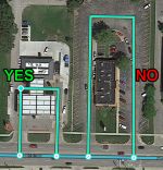
Any loop that does not follow this rule can cause problems for the Waze routing server. If there is no side-street, you must insert an extra junction node along the loop. Many new editors will see the extra junction node(s), assume they are not needed, and delete them. This YouTube video shows how to fix a loop that only has two segments.
Too short
When a segment is less than 6m it becomes difficult for the navigation engine to determine traffic speed through that segment. That will in turn negatively affect drive time estimations and best routing.
Between intersections
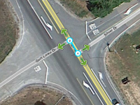
There may be times when driveways or other roads join a main road with close proximity to each other. This may cause small segments to be created between the two junctions along that main road. If the segment is shorter than 6m, it may be best to simply merge the two intersections into a single junction. It is OK if the joining roads in the map do not exactly align with the visual map in the Waze Map Editor.
Offset Roads
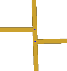
Sometimes you will find two roads which cross, where one does not quite line up with the other.
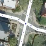
There are a few things we need to look at in this situation.
- Do the roads actually line up in reality? If so we need to modify the junction to be a basic 4-way junction.
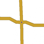
|
|
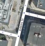
- Do the roads ALMOST line up in reality? If you were giving instructions to a person and would tell them to go straight with no mention of any slight turn or jog, then we want to make it into a 4-way junction. You may need to "split the difference" and not follow the centerline of either road to achieve this. The angles are exaggerated in this next example to show how the junction is forced to be close to 90 degrees, then we taper to the true centerlines of the roads. In practice this can be much more gradual and/or done while zoomed in very close.
- Finally, is there a true separation between the roads? Would you need to say for example "turn left then make an immediate right"? If so then we will want to leave the junction such that the two sides do not align.
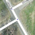
Since we want to avoid very short segments of road (the GPS chips in consumer devices can be very inaccurate which may make it seem that a driver skipped right over a short segment. This will result in automated map errors and possible route recalculations in the client,) it may be wise to shift the side roads as far apart from each other as possible with them still in the proper location (along the far curb lines for a residential street for example). This will maximize the length of the short segment between the side roads.
Road Types
Pakistan is made up of many different types and styles of roads. Below is a list of a few of them.
- Motorway (MWY) - Motorways (limited access roads with no signal control)
- Major Highway (MH) - All National Highways (which have numbers likes N5 or N39)
- Minor Highway (mH) - All roads that connect two cities.
- Primary Street (PS) - Major in-city roads and roads to small villages/Chak.
- Street - Streets within a city that are not listed as above. Typically neighbourhood roads.
- Private Road (PR) - Used for gated communities or private roads where the public would not be allowed to be routed through.
- Parking Lot Road (PLR) - Roads within a Parking Lot Area, such as shopping centers, Petrol Pumps etc.
Speed Limits
Rural Areas
- 120 km/hr
- (ONE WAY) 100 km/hr
- (TWO WAY) 80 km/hr
- (ONE WAY) 100 km/hr
- (TWO WAY) 80 km/hr
- 60 km/hr
- 50 km/hr
Urban Areas
- 120 km/hr
- (ONE WAY) 50 km/hr
- (TWO WAY) 50 km/hr
- (ONE WAY) 50 km/hr
- (TWO WAY) 50 km/hr
- 50 km/hr
- 40 km/hr
ISB, KHI & LHE
- 120 km/hr
- (ONE WAY) 80 km/hr
- (TWO WAY) 80 km/hr
- (ONE WAY) 80 km/hr
- (TWO WAY) 80 km/hr
- 60 km/hr
- 50 km/hr
* ISB: Islamabad (The Capital of Pakistan), KHI: Karachi (Sindh Province Capital), LHE: Lahore (Punjab Province Capital)
Lock Levels
Minimum Road Lock Standard
| All Segments with the Toll Flag are to be locked to L5. Do not cut, delete, merge or disconnect any segment of a toll flag without consulting local leadership, preferably someone with access to the toll tool. Doing so may break a toll price file. |
| Minimum Road Lock Standard | ||
|---|---|---|
| Segment Type | Level | |
| Motorway (MWY) | 4 | |
| Ramp | HCS* | |
| Major Highway (MH) | 4 | |
| Minor Highway (mH) | 3 | |
| Primary Street (PS) | 2 | |
| Street | 1 | |
| Private Road (PR) | 1 | |
| Parking Lot Road (PLR) Parking Lot Road (Petrol Pumps) |
1
2 | |
| |-|-|-|-|-|-|-|-|-| Railroad |-|-|-|-|-|-|-|-|-| | 2 | |
| • • • • Ferry • • • • | 3 | |
| ⁃ ⁃ ⁃ ⁃ ⁃ Runway ⁃ ⁃ ⁃ ⁃ ⁃ | 4 | |
* HCS - Locked to the Highest Connecting Segment Lock Level (mH to FWY ramp would be locked to 4)
| The lock levels above are minimums, meaning that segments may have higher locks. Note: Do Not Mass Edit just to update locks to these standards, these can be adjusted as you find them while editing other aspects of the segments. |
Places
Places are searchable destinations in the Waze map. They are similar to the "points of interest" found in certain popular GPS devices.
Area Places appear as polygons in the Waze app. Too many of them can clutter the map, creating large gray zones that do not help Wazers orient themselves. Therefore, it is important to use area places only when they are distinctive and significant enough to orient drivers. Exceptions include gas stations, and parking lots which receive special handling.
Point Places don't appear on the Waze app map. They can be used to help Wazers find public places, especially when they are not already listed in the other destination search engines.
Residential Point Places don't appear on the Waze app map. They can be used for help Wazers find addresses by searching; can be used for residences or businesses.
Non-residential point places and area places appear in both autocomplete and full search in the Waze app. The table of place categories and types in the Global Wiki, provides guidelines to help map editors decide between point and area places. The only change from that table for Pakistan is that Religious Centers are to be an Area Place
Gas Stations
The Gas Stations feature in the Waze app is active in Pakistan. Prices can only be updated by users in the app. You must be within a radius of 0.3 miles/500 meters and above the rank of a baby Wazer to update gas prices.
A complete and accurate Gas Station Place enables drivers to search for their favorite brands of fuel and the best fuel prices near their current location or route. More about the gas station functionality in the client can be found in the Waze Help Center.
Refer to the Pakistan Gas Station page for detailed information on adding Gas Stations in Pakistan
Problem Reports
In the Waze Map Editor we can see two different kind of Problem Reports:

 URs (Update Requests; map problems reported by Waze users)
 MPs (automatically generated Map Problems)
They show where the map needs work. We must solve them to fix the map. URs also give us a way to contact our fellow Wazers, who may become interested in editing.
Other reports on the map are ![]() Place Update Requests (PURs), which are covered on the page about Places in the Global Wiki.
Place Update Requests (PURs), which are covered on the page about Places in the Global Wiki.
Bugs and limitations
Although we think Waze gives the best possibilities for navigation, it knows some problems and limitations as well. Specific for Pakistan are the following:
- The map needs to be improved
- Due to the status of the road network and the yet small community, the map in Pakistan is not of high quality everywhere. However, the current editing community is working hard to improve the map. You help already by driving with Waze on! And if you are in for an adventure, you might add new roads to the map, or even become a
 Waze Map Editor.
- Long distance routing
- Setting a route over long distances puts a lot of weight on the servers. Depending on the map quality, you can expect routes up to any distance. At this moment, maximum route length will often be less in Pakistan*. If you request a route and the calculation time is too long, you'll receive an error saying "Routing server timeout" or "no route found". We recommend breaking up longer routes into several segments by choosing intermediate destinations.
- * Note that we are currently upgrading the road network to get better and longer routes!
- Known issues in the current app version are listed on the support pages

Wishing you fun and happy travels with Waze in Pakistan!