m (→Entrance ramps) |
|||
| (One intermediate revision by the same user not shown) | |||
| Line 1: | Line 1: | ||
== Introduction == | ==Introduction== | ||
Editors are encouraged to follow these guidelines. | Editors are encouraged to follow these guidelines. | ||
== Road types == | ==Road types== | ||
The following convention is the recommended way to label road types in New Zealand. | The following convention is the recommended way to label road types in New Zealand. | ||
| Line 12: | Line 12: | ||
===Freeway=== | |||
=== Freeway === | |||
{| class="wikitable unsortable" style="background:white; font-size:80%; margin: 1em auto 1em auto" border="1" width="100%" | {| class="wikitable unsortable" style="background:white; font-size:80%; margin: 1em auto 1em auto" border="1" width="100%" | ||
|- | |- | ||
! Waze Road Type | !Waze Road Type | ||
! Description | !Description | ||
! style="width: 5%; background-color: white;" | Road Shield Examples | ! style="width: 5%; background-color: white;" |Road Shield Examples | ||
|- | |- | ||
| Freeway (Motorway) | |Freeway (Motorway) | ||
| Freeway, motorway, and expressway. There must be no intersections and there must be no access or exits except from ramps. [http://en.wikipedia.org/wiki/List_of_motorways_and_expressways_in_New_Zealand List of motorways and expressways in New Zealand.] | |Freeway, motorway, and expressway. There must be no intersections and there must be no access or exits except from ramps. [http://en.wikipedia.org/wiki/List_of_motorways_and_expressways_in_New_Zealand List of motorways and expressways in New Zealand.] | ||
| [[File:SH1 SH1.jpg|50px|SH1 SH1.jpg]] | |[[File:SH1 SH1.jpg|50px|SH1 SH1.jpg]] | ||
|} | |} | ||
| Line 33: | Line 32: | ||
{| class="wikitable unsortable" style="background:white; font-size:80%; margin: 1em auto 1em auto" border="1" width="100%" | {| class="wikitable unsortable" style="background:white; font-size:80%; margin: 1em auto 1em auto" border="1" width="100%" | ||
|- | |- | ||
! Code | !Code | ||
! WME Entry | !WME Entry | ||
! Client Display | !Client Display | ||
|- | |- | ||
| <SH xx> | |<SH xx> | ||
| SH 1 | |SH 1 | ||
| [[File:SH1 SH1.jpg|50px|SH1 SH1.jpg]] | |[[File:SH1 SH1.jpg|50px|SH1 SH1.jpg]] | ||
|} | |} | ||
=== Major Highway === | ===Major Highway=== | ||
{| class="wikitable unsortable" style="background:white; font-size:80%; margin: 1em auto 1em auto" border="1" width="100%" | {| class="wikitable unsortable" style="background:white; font-size:80%; margin: 1em auto 1em auto" border="1" width="100%" | ||
|- | |- | ||
! Waze Road Type | !Waze Road Type | ||
! Description | !Description | ||
! style="width: 5%; background-color: white;" | Road Shield Examples | ! style="width: 5%; background-color: white;" |Road Shield Examples | ||
|- | |- | ||
| Major Highway | |Major Highway | ||
| Are roads named from SH 1 to SH 99 | |Are roads named from SH 1 to SH 99 | ||
| [[File:SH5 SH5.jpg|50px|SH5 SH5.jpg]][[File:SH3a SH3a.jpg|50px|SH3a SH3a.jpg]] | |[[File:SH5 SH5.jpg|50px|SH5 SH5.jpg]][[File:SH3a SH3a.jpg|50px|SH3a SH3a.jpg]] | ||
|} | |} | ||
*Road Type: Major | *Road Type: Major | ||
*City: N/A (Tick "None" Checkbox) | *City: N/A (Tick "None" Checkbox) | ||
*Lock: Level 3 for State Hwy 1, Level 2 for all other Hwy's | *Lock: Level 3 for State Hwy 1, Level 2 for all other Hwy's | ||
*Name: <SH xx> | *Name: <SH xx> | ||
{| class="wikitable unsortable" style="background:white; font-size:80%; margin: 1em auto 1em auto" border="1" width="100%" | {| class="wikitable unsortable" style="background:white; font-size:80%; margin: 1em auto 1em auto" border="1" width="100%" | ||
|- | |- | ||
! Code | !Code | ||
! WME Entry | !WME Entry | ||
! Client Display | !Client Display | ||
|- | |- | ||
| <SH xx> | |<SH xx> | ||
| SH 5 | |SH 5 | ||
SH 1 - Clyde St | SH 1 - Clyde St | ||
| [[File:SH5 SH5.jpg|50px|SH5 SH5.jpg]] | |[[File:SH5 SH5.jpg|50px|SH5 SH5.jpg]] | ||
|- | |- | ||
| <SH xx> | |<SH xx> | ||
| SH 3a | |SH 3a | ||
| [[File:SH3a SH3a.jpg|50px|SH3a SH3a.jpg]] | |[[File:SH3a SH3a.jpg|50px|SH3a SH3a.jpg]] | ||
|} | |} | ||
=== Minor Highway === | ===Minor Highway=== | ||
{| class="wikitable unsortable" style="background:white; font-size:80%; margin: 1em auto 1em auto" border="1" width="100%" | {| class="wikitable unsortable" style="background:white; font-size:80%; margin: 1em auto 1em auto" border="1" width="100%" | ||
|- | |- | ||
! Waze Road Type | !Waze Road Type | ||
! Description | !Description | ||
! style="width: 5%; background-color: white;" | Road Shield Examples | ! style="width: 5%; background-color: white;" |Road Shield Examples | ||
|- | |- | ||
| Minor Highway | |Minor Highway | ||
| Are Regional Routes | |Are Regional Routes | ||
| [[File:SH72 SH72.jpg|50px|SH72 SH72.jpg]] | |[[File:SH72 SH72.jpg|50px|SH72 SH72.jpg]] | ||
|} | |} | ||
| Line 103: | Line 101: | ||
{| class="wikitable unsortable" style="background:white; font-size:80%; margin: 1em auto 1em auto" border="1" width="100%" | {| class="wikitable unsortable" style="background:white; font-size:80%; margin: 1em auto 1em auto" border="1" width="100%" | ||
|- | |- | ||
! Code | !Code | ||
! WME Entry | !WME Entry | ||
! Client Display | !Client Display | ||
|- | |- | ||
| <TR xx> <Name> | |<TR xx> <Name> | ||
| TR 72 - Geraldine-Winchester Hwy | |TR 72 - Geraldine-Winchester Hwy | ||
| [[File:SH72 SH72.jpg|50px|SH72 SH72.jpg]] Geraldine-Winchester Hwy | |[[File:SH72 SH72.jpg|50px|SH72 SH72.jpg]] Geraldine-Winchester Hwy | ||
|- | |- | ||
| <UR xx> <Name> | |<UR xx> <Name> | ||
| UR 9 - Remuera Rd | |UR 9 - Remuera Rd | ||
| [[File:SH72 SH72.jpg|50px|SH72 SH72.jpg]] Remuera Rd | |[[File:SH72 SH72.jpg|50px|SH72 SH72.jpg]] Remuera Rd | ||
|} | |} | ||
=== Primary Street === | ===Primary Street=== | ||
{| class="wikitable unsortable" style="background:white; font-size:80%; margin: 1em auto 1em auto" border="1" | {| class="wikitable unsortable" style="background:white; font-size:80%; margin: 1em auto 1em auto" border="1" | ||
|- | |- | ||
! Waze Road Type | !Waze Road Type | ||
! Description | !Description | ||
! Road Shield Examples | !Road Shield Examples | ||
|- | |- | ||
| Primary Street | |Primary Street | ||
| Main Roads, Regional Roads, Tourist Drives, Scenic Drives, etc that are not classified as highways. They connect suburbs and towns. | |Main Roads, Regional Roads, Tourist Drives, Scenic Drives, etc that are not classified as highways. They connect suburbs and towns. | ||
| N/A | |N/A | ||
|} | |} | ||
| Line 132: | Line 130: | ||
*City: City Name | *City: City Name | ||
*Name: Millwater Parkway | *Name: Millwater Parkway | ||
*Lock: Level | *Lock: Level 2 | ||
=== Street === | ===Street=== | ||
{| class="wikitable unsortable" style="background:white; font-size:80%; margin: 1em auto 1em auto" border="1" | {| class="wikitable unsortable" style="background:white; font-size:80%; margin: 1em auto 1em auto" border="1" | ||
|- | |- | ||
! Waze Road Type | !Waze Road Type | ||
! Description | !Description | ||
! Road Shield Examples | !Road Shield Examples | ||
|- | |- | ||
| Street | |Street | ||
| Urban streets and rural roads not identified above. Use also when in doubt of proper street type. | |Urban streets and rural roads not identified above. Use also when in doubt of proper street type. | ||
| N/A | |N/A | ||
|} | |} | ||
| Line 152: | Line 150: | ||
*Lock: Level 1 | *Lock: Level 1 | ||
=== Locking Roads === | ===Locking Roads=== | ||
[[Best map editing practice#Locking Segments|Guide for locking]] | [[Best map editing practice#Locking Segments|Guide for locking]] | ||
| Line 164: | Line 162: | ||
When creating a new road in an area not yet mapped area and locking it to a level above 1, you also may choose to add just one short segment of an adjoining road (handle) to create the junction and allow a lower level editor to connect the surrounding streets later without being blocked from editing. | When creating a new road in an area not yet mapped area and locking it to a level above 1, you also may choose to add just one short segment of an adjoining road (handle) to create the junction and allow a lower level editor to connect the surrounding streets later without being blocked from editing. | ||
== Motorway Carriageway Naming Convention == | ==Motorway Carriageway Naming Convention== | ||
Whenever possible, on split roads, name carriageways with the direction of travel. Insert the direction of travel at the end of the road name: | Whenever possible, on split roads, name carriageways with the direction of travel. Insert the direction of travel at the end of the road name: | ||
| Line 180: | Line 178: | ||
This makes traffic and incident reports much more useful and helps with navigation. | This makes traffic and incident reports much more useful and helps with navigation. | ||
== Exit and Entrance ramps (on/off ramps) == | ==Exit and Entrance ramps (on/off ramps)== | ||
[[File:Exit 394 Whangarei via Orewa.jpg|thumb|right|250px]] | [[File:Exit 394 Whangarei via Orewa.jpg|thumb|right|250px]] | ||
| Line 191: | Line 189: | ||
===Exit ramps=== | |||
=== Exit ramps === | |||
*If the exit sign shows a number as well as a street or highway name, the exit ramp should be named. The hyphen gets transferred to "to" in the TTS | *If the exit sign shows a number as well as a street or highway name, the exit ramp should be named. The hyphen gets transferred to "to" in the TTS | ||
| Line 225: | Line 222: | ||
Exit 424 B C: SH 16 (E) - Cook St / Port | Exit 424 B C: SH 16 (E) - Cook St / Port | ||
=== Entrance ramps === | ===Entrance ramps=== | ||
For entrance ramps, use this format. | For entrance ramps, use this format. | ||
| Line 236: | Line 233: | ||
<div style="clear:both;"></div> | <div style="clear:both;"></div> | ||
== Wayfinder Segments == | ==Wayfinder Segments== | ||
It may be necessary to provide additional information to a driver for complex or confusing Exits and Splits[[Junction Style Guide#Wayfinder Segments|More details here]]. | It may be necessary to provide additional information to a driver for complex or confusing Exits and Splits[[Junction Style Guide#Wayfinder Segments|More details here]]. | ||
| Line 247: | Line 244: | ||
SH 1 (S) - Manukau / Hamilton | SH 1 (S) - Manukau / Hamilton | ||
== Roundabouts == | ==Roundabouts== | ||
To aid navigation instructions, roundabouts should typically remain without a '''street name''' | To aid navigation instructions, roundabouts should typically remain without a '''street name''' | ||
*City: enter either | *City: enter either '''Primary City''' or tick "None" | ||
*Street: Tick "None" | *Street: Tick "None" | ||
Latest revision as of 15:56, 31 October 2021
Introduction
Editors are encouraged to follow these guidelines.
Road types
The following convention is the recommended way to label road types in New Zealand.
NOTE: When Labelling Freeways and Highways where possible avoid changes to, "Road Type", "City Name" and "Street Name" over many road sections.
For example routing from Cape Reinga to Wellington using only using "SH 1" label format, routing would be much improved if every segment was named exactly the same.
Freeway
| Waze Road Type | Description | Road Shield Examples |
|---|---|---|
| Freeway (Motorway) | Freeway, motorway, and expressway. There must be no intersections and there must be no access or exits except from ramps. List of motorways and expressways in New Zealand. | 
|
- Road Type: Freeway (Same as NZ Motorway)
- City: N/A (Tick "None" Checkbox)
- Lock: Level 3 (Note: Auckland is Level 4)
- Name: <SH xx>
| Code | WME Entry | Client Display |
|---|---|---|
| <SH xx> | SH 1 | 
|
Major Highway
| Waze Road Type | Description | Road Shield Examples |
|---|---|---|
| Major Highway | Are roads named from SH 1 to SH 99 |  
|
- Road Type: Major
- City: N/A (Tick "None" Checkbox)
- Lock: Level 3 for State Hwy 1, Level 2 for all other Hwy's
- Name: <SH xx>
| Code | WME Entry | Client Display |
|---|---|---|
| <SH xx> | SH 5
SH 1 - Clyde St |

|
| <SH xx> | SH 3a | 
|
Minor Highway
| Waze Road Type | Description | Road Shield Examples |
|---|---|---|
| Minor Highway | Are Regional Routes | 
|
- Road Type: Minor
- City: N/A (Tick "None" Checkbox)
- Lock: Level 2
- Name: <TR xxx>" - "<Name>
- Name: <UR xxx>" - "<Name>
Note: Text to Speach for
 TR = Tourist Route
 UR = Urban Route
| Code | WME Entry | Client Display |
|---|---|---|
| <TR xx> <Name> | TR 72 - Geraldine-Winchester Hwy |  Geraldine-Winchester Hwy Geraldine-Winchester Hwy
|
| <UR xx> <Name> | UR 9 - Remuera Rd |  Remuera Rd Remuera Rd
|
Primary Street
| Waze Road Type | Description | Road Shield Examples |
|---|---|---|
| Primary Street | Main Roads, Regional Roads, Tourist Drives, Scenic Drives, etc that are not classified as highways. They connect suburbs and towns. | N/A |
- Road Type: Primary
- City: City Name
- Name: Millwater Parkway
- Lock: Level 2
Street
| Waze Road Type | Description | Road Shield Examples |
|---|---|---|
| Street | Urban streets and rural roads not identified above. Use also when in doubt of proper street type. | N/A |
- Road Type: Street
- City: City Name
- Name: Streetname according to postal adress
- Lock: Level 1
Locking Roads
Locking should be used sparingly and carefully.
A special note on locking:

When creating a new road in an area not yet mapped area and locking it to a level above 1, you also may choose to add just one short segment of an adjoining road (handle) to create the junction and allow a lower level editor to connect the surrounding streets later without being blocked from editing.
Motorway Carriageway Naming Convention
Exit and Entrance ramps (on/off ramps)


For the best balance between information and screen real estate, the following conventions are used. All ramps will be set as the 'ramp' type in the Waze Map Editor and be locked at the same level as the freeway which joins to them. The name of the road, route number (if applicable) and compass direction (for entrance ramps) should all be added for clear guidance to be given when using the Waze app.
Exit ramps
- If the exit sign shows a number as well as a street or highway name, the exit ramp should be named. The hyphen gets transferred to "to" in the TTS
"Exit 424 B: Cook St"
The hyphen gets transferred to "to" in the TTS (Text-to-Speech)
- If the exit is not numbered,
"Exit: SH 50 - Hastings / Wellington"
- If a single exit serves multiple roads, use a slash with leading and trailing spaces:
"Exit: SH 50 - Hastings / Wellington"
- If an exit number contains one or more letters, include it exactly as displayed on the sign:
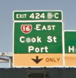
"Exit 424 B C: State Hwy 16 (E) - Cook St / Port"
- Include everything that is present on the last sign prior to the exit. Do not combine all possible pre-ramp signage into the single ramp segment name.
- If the exit off the main interstate or highway serves multiple exits further down the road, it may be advisable not to name the first exit ramp, to name only the ramps which are the first one to a distinct destination. The Waze client will give all the proper exit and keep left or right instructions to guide the driver to the correct exit, even if the first one is not named. That said, this should only be done if the signage for the first ramp is the same as that on the subsequent, named ramp.
Examples
Exit: SH 50 - Hastings / Wellington
Exit 394: Whangarei via Orewa
Exit 424 B: Cook St
Exit 398: Silverdale
Exit: Service Centre
Exit 424 B C: SH 16 (E) - Cook St / Port
Entrance ramps
For entrance ramps, use this format.
Examples
Entry: SH 1 (S) - Auckland
Entry: SH 1 (N) - Whangarei
Entry: SH 18 - Mtwy (E) - North Shore
Wayfinder Segments
It may be necessary to provide additional information to a driver for complex or confusing Exits and SplitsMore details here.
Wayfinder Naming Examples
SH 1 - Auckland / Whangarei
SH 1 - Auckland (S)
Exit 424: B C D - SH 16 (E) and (W)
SH 1 (S) - Manukau / Hamilton
Roundabouts
To aid navigation instructions, roundabouts should typically remain without a street name
- City: enter either Primary City or tick "None"
- Street: Tick "None"
- where the client comes across a segment with no name it will use the next named segment as the next named instruction whilst retaining any turn signals.
If the roundabout does have a proper, signposted name, then this can be labelled using a 'Junction/Intersection' type landmark that fills the centre of the roundabout.
- For further advice, see Editing Junctions and Roundabouts
