Segment Properties
Properties relevant for most Road typesː
- Page on Street and City names.
- Page on Road shield.
- Page on Tunnels.
- Page on Speed limit.
- Page on Lane Guidance.
- Page on House numbers.
- Page on New Housing Development.
- Page on Elevation.
- Page on Lock level.
- Page on Nodes.
Unpaved
Check the Unpaved attribute for any by regular car driveable road which is not paved.
The app has a setting for using Unpaved roads. The default is "Don't allow". Other values are "Allow" and "Avoid long ones". ((> +/- 400m))
If a road is unpaved, only driveable by a 4x4 and really should be mapped, than - in this exceptional case - the Off-road road type may be used.
Next to carpool/HOV/bus lane
Indicates if a road segment is next to a separated HOV or buslane segment. By checking this attribute possible GPS-deviation is taken into account when calculating the estimated time of arrival.
GPS-devaition may has as effect that speed information is assigned to the wrong (adjacent) segment.
Minimum segment length
A segment should not be shorter than 6 meters.
Headlights required
The headlight warning is given each time in the app when a route is started that passes a segment with Headlight required checked. This warning only makes sense in the few countries for which this warning was developed. Better leave this attribute unchecked.
Average Speed Cameras

Check on all road segments where average speed cameras are operational the ![]() Average Speed Camera check boxes. If a ASC zone starts or ends in the middle of an existing (longer) segment, you may have to add a new node (by splitting the segment), to get the ASC notifications to start / end at the correct locations. If the start/end is approximately 20m from an existing node, this is not necessary.
Average Speed Camera check boxes. If a ASC zone starts or ends in the middle of an existing (longer) segment, you may have to add a new node (by splitting the segment), to get the ASC notifications to start / end at the correct locations. If the start/end is approximately 20m from an existing node, this is not necessary.
If the cameras are already placed but not yet operational use dummy camera's.
Currently , due to a bug, a Average speed control should always start at the A point of a segment. In case of a two way average speed control it may be necessary to split a segment in two parts, change the A and B points of the newly created segment with as result that from both ways the average speed control can be defined on a segment starting with an A point. The A-point triggers the warning message.
Aspects
- Page on Junction Arrows
- Page on Junction Box
Keep It Simple/Stupid (KISS)
"As simple as possible, as complex as necessary"
KISS is keeping the road geometry as simple as possible, without losing the essential driving instructions.
More info, see the KISS page.
Filter lanes

Filter lanes are not mapped as separate segments but can be configured as Lane Guidance.
Filter lanes, as separate segments, don't fit the KISS principle because they are the cause of very complex situations that are hard to manage, while they don't add a lot of value in most routing instructions. Short segments and extra splits can have a negative influence on routing (extra penalty, incorrect average speeds, ...).
Of course, there is always an exception. If the choice of a filter lane must be made more than 50 meter before coming to the crossing AND the main road and filter lane are divided by obstacles (concrete blocks, ...), it should be mapped.
Splitting roads

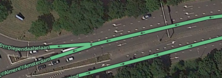
The standard representation for any roadway is a single 2-way segment, even if the physical roadway is divided.
A road may be divided when the GPS tracks show two clearly definable flows at the 100m 500ft zoom level.
There are a few extra considerations when the road has possible destinations / addresses.
A street with physical separated lanes with addresses/destinations - fi. with parking in between, separated by a ditch, strips of grass or bushes or an other obstacle - can be drawn in different ways. Most important consideration when choosing: the best navigation to, if possible, the front door of your destination.
Two possibilities:
- Separate 1-way traffic segments with connecting roads in between.
- 2-way traffic segments with U-turn arrows on green at the connecting roads. (The KISS variant)
Considerations to consider when choosing between both variants:
Separated 1-way traffic segments
Advantage: map image in the app corresponds to reality.
Disadvantage: crowded map image in app and WME, (too) little space for the connecting roads due to the minimum segment length of 6 meters, U- turn prevention can occur with higher road types.
KISS variant
Advantage: clear, uncluttered map image in the app and WME, no problems with U-turn prevention.
Disadvantage: map image deviates from the street image, editing is more difficult, green U-turn arrows can mislead editors. Navigation to destination without taking into account any difficulties in reaching the front door of your destination due to a blocking lane divider.
Also important when choosing an option is:
- does it matter which side to come from?
- can I still get to my destination from the side where I arrive? Or do I first have to cross fences / roadsides / ditches?
If so, split away. If not, then do not split. Because why be sent all the way around the block while you can just drive straight there.
How to divide
- Note how the 2-way segment currently is connected to the connecting segments. Which incoming/outgoing traffic movements are possible.
- Cut the 2-way segment into two parts and separate them.
- Make both segments 1-way traffic.
- Extend both segments so that they are parallel to each other.
- Connect both segments to the surrounding segments, as noted in the first step.
See also this video How to divide a two-way- road.
Merge two 1-way traffic segments
Merging two 1-way traffic segments into one 2-way traffic segment is only possible if both segments have the same name, type, maximum speed and locking level.
Merging a road split in two 1-way traffic to one 2-way traffic segment is best done like this:
- Select both 1-way traffic segments to merge.
- Change the selected segments to 2-way traffic.
- Detach both selected segments on one side. One segment on one side, the other on the other.
- Bring the loose ends of both segments together and connect them.
- Delete the now created connection node.
- Move the new 2-way traffic segment in the middle of the road.
- Check the arrows of all incoming and outgoing directions
- Now set the stop point / segment marker of any house numbers correctly.
Roundabouts
If you want to add a Roundabout, you firstly draw the roads as a normal crossroad, but don't connect the roads/segments. Secondly you draw the Roundabout and WME will connect the crossing roads automatically.
A Roundabout must always get a city name but never a streetname. The reason for this has to do with the navigation instructions and road announcements. A Roundabout always gets categorized as the type of the highest connected road.
See the Roundabout page.
Shopping streets
Shopping streets only allowed for pedestrians (and cyclists) with the exception of certain hours loading/unloading, are defined as Private Roads.
Double left and double right

The Waze routing algorithm prevents double-left or double-right turns by using an extremely large U-turn penalty when these conditions are met:
- Three segments: The U-turn is a reversal of driving direction through three segments: an incoming segment (A), a single median segment (B) and an outgoing segment (C).
- Short median: The median segment (B) is shorter than or equal to 15 meters.
- In/out parallelism: The in and out segments (A and C) are within ±5° of parallel to each other. If the median segment isn't straight calculate the degrees as if an imaginary straight segment was connectining the A and C segments.
- Not all the A, B and C segments are Street.
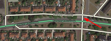
Example / see picture: Driving from left to right on the top street (A) with destination towards the west requires a reversal of driving direction. When the median segment B (red arrow) is 15 meters or less the app will navigate over the lower street towards the west. Only if this median segment is 16 meters or more the app will navigate over the bigger road in the middle (C).
See also the global page on Routing penalties/Controlling U-turn penalties