==Places==
Places are searchable destinations in the Waze map, just like the "Points of Interest" found in certain popular GPS devices. They can be added from the client, but also in the Waze Map Editor. Here you'll find the instructions on how to create a Place in the WME.
A Place can be a Point or an Area. Above a given size Area Places become visible in the client. A Point Place is never visible, but both types can be searched and navigated to. There is also a third kind of Place called Residential, which are private addresses. These are always Point Places.
Point Places
Point Places don't show on the Wazers device. They can be used to help Wazers find locations, especially when they are not or wrongly listed in other destination search engines. As they are searchable from the app, accurate positioning of a point location and providing a full address (including street number) are both utterly important.
In the WME, a Point appears as a small circle:
![]() Standard point
Standard point
![]() Modified point, pending for approval
Modified point, pending for approval
The Waze routing server will navigate the Wazer onto the segment which is physically closest to where the Point is placed.
The Point Marker is the stop point. Typically, if the Place is inside a building, the marker should be located at or near the location's main entrance door. Try to imagine where you would stop to drop someone off for this location.
Area Places
Area Places appear in the Waze app. Too many of them can clutter the map, creating large gray zones that do not help Wazers orient themselves. Therefore, it is important to use Area Places only when they are distinctive and significant enough to orient drivers. Care should be taken not to snap to road segment nodes, because this makes it more difficult to edit the place and/or segments later on.
Area Places should have a minimum area size of 500 m2 (e.g., 10m x 50m) to be visible in the client's display. Most of the other places are Point Places, except for Gas Stations, and Parking Lots, which are always areas, and receive special handling. See also the paragraph on how to determine Area or Point.
Generally, an Area Place only covers what a Wazer sees when driving to the actual location. It follows that the Area outline covers the building of the place, but never the whole property. However, an Area Place doesn't have to be as detailed as the building is, actually, it's better to keep the shape roughly.
Natural features such as forests, parks, and lakes are drawn to the visible contours.
The different types of Area Places show in different colors in the app, as well as in WME. The colors vary slightly, depending on your display. Generally, Natural features show green (e.g., Park) or blue (e.g., River).

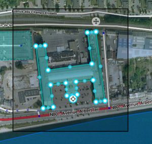
Each Area Place has a ![]() “Point Marker“ , which by default is centered. This point can be moved to where you should arrive, or where to park, even a short distance outside of the marked area, indicated by the black outline (see picture). Again, try to imagine where you would stop to drop someone off for this location.
“Point Marker“ , which by default is centered. This point can be moved to where you should arrive, or where to park, even a short distance outside of the marked area, indicated by the black outline (see picture). Again, try to imagine where you would stop to drop someone off for this location.
If the Area itself needs to be modified, click on the place to select it. Use the geometry points to adjust the shape. To move an area place without changing its shape, drag the ![]() Move Handle icon.
Move Handle icon.