Geen bewerkingssamenvatting |
Geen bewerkingssamenvatting |
||
| Regel 26: | Regel 26: | ||
<!--T:2--> | <!--T:2--> | ||
''' | '''Traject controle'''<br /> | ||
[[File:Average-speed-camera.png|right]] | [[File:Average-speed-camera.png|right]] Vink op alle wegsegmenten waar [[Speed|traject controle]] camera's operationeel zijn de Traject controle aan. Je kunt een langer [[Additional editing tips|segment splitsen]] wanneer een TC zone start of eindigt in het midden van het oorspronkelijke segment om zo de TC te laten starten/eindigen op de juiste plaats. Splitsen is niet nodig wanneer start/einde op maximaal 20m afstaat van het bestaande segment.<br /> | ||
[Camera#False_Camera|Dummy camera's]] kunnen gebruikt worden wanneer de camera's al wel geplaatst zijn maar nog niet operationeel zijn.<br /> | |||
<!--T:14--> | <!--T:14--> | ||
<small> | <small>Op dit moment moet, vanwege een bug, een <i>Traject controle</i> altijd beginnen met het A punt van een segment. Wanneer het een 2-richtings segment betreft kan het noodzakelijk zijn om het segment te splitsen in twee een-richting verkeers segmenten zodat het mogelijk is om bij beide richtingen de TC te beginnen op het A punt. Het A-punt zorgt voor de waarschuwing in de app.</small><br /> | ||
<br /> | <br /> | ||
<div style="clear: both"></div> | <div style="clear: both"></div> | ||
=== | ===Aspecten=== <!--T:15--> | ||
* Page on [[Junction Arrows]] | * Page on [[Junction Arrows]] | ||
* Page on [[Junction Box]] | * Page on [[Junction Box]] | ||
Versie van 23 okt 2020 11:37
Segment eigenschappen
Eigenschappen die van belang zijn voor de meeste Wegtypenː
- Pagina over Straat- en plaatsnamen.
- Pagina over Maximum snelheid.
- Pagina over Rijstrookaanwijzing.
- Pagina over Huisnummers.
- Pagina over Nieuwe wijk.
- Pagina over Hoogte.
- Pagina over Lock niveau.
- Pagina over Nodes, segmentknooppunten.
Onverharde weg
Vink het Onverharde weg attribuut aan bij elke weg die voor een normale auto berijdbaar is en die geen verharding heeft.
De app heeft een instelling voor het al dan niet gebruiken van Onverharde wegen. Standaard staat deze op "Niet toestaan". Andere mogelijke warden zijn "Toestaan" and "Vermijd lange stukken (> +/- 400m)".
Kies alleen, in het uitzonderlijke geval, dat een niet verharde weg alleen berijdbaar is met een 4x4 en echt op de kaart hoort te staan, voor het Off-road wegtype.
Minimum segment lengte
Een segment mag niet korter zijn dan 6 meters.
Dimlicht verplicht
In de app wordt de dimlicht waarschuwing elke keer gegeven wanneer een route gestart wordt waarin een segment gepasseerd wordt met Dimlicht verplicht aangevinkt. Deze waarschuwing is alleen zinvol in de paar landen waarvoor deze werd ontwikkeld. Het is beter dit attribuut niet aan te vinken.
Traject controle

Vink op alle wegsegmenten waar traject controle camera's operationeel zijn de Traject controle aan. Je kunt een langer segment splitsen wanneer een TC zone start of eindigt in het midden van het oorspronkelijke segment om zo de TC te laten starten/eindigen op de juiste plaats. Splitsen is niet nodig wanneer start/einde op maximaal 20m afstaat van het bestaande segment.
[Camera#False_Camera|Dummy camera's]] kunnen gebruikt worden wanneer de camera's al wel geplaatst zijn maar nog niet operationeel zijn.
Op dit moment moet, vanwege een bug, een Traject controle altijd beginnen met het A punt van een segment. Wanneer het een 2-richtings segment betreft kan het noodzakelijk zijn om het segment te splitsen in twee een-richting verkeers segmenten zodat het mogelijk is om bij beide richtingen de TC te beginnen op het A punt. Het A-punt zorgt voor de waarschuwing in de app.
Aspecten
- Page on Junction Arrows
- Page on Junction Box
Keep It Simple/Stupid (KISS)
"As simple as possible, as complex as necessary"
KISS is keeping the road geometry as simple as possible, without losing the essential driving instructions.
More info, see the KISS page.
Filter lanes

Filter lanes are not mapped as separate segments but can be configured as Lane Guidance.
Filter lanes, as separate segments, don't fit the KISS principle because they are the cause of very complex situations that are hard to manage, while they don't add a lot of value in most routing instructions. Short segments and extra splits can have a negative influence on routing (extra penalty, incorrect average speeds, ...).
Of course, there is always an exception. If the choice of a filter lane must be made more than 50 meter before coming to the crossing AND the main road and filter lane are divided by obstacles (concrete blocks, ...), it should be mapped.
Splitting roads

The standard representation for any roadway is a single 2-way segment, even if the physical roadway is divided.
A road may be divided when the GPS tracks show a clearly definable and continuous gap (blank area) between the color-by-azimuth arrows at the 100m 500ft zoom level.
Ring roads
There are roads that could be classified by multiple street types. We think of ring roads (R-roads) which sometimes can also be a N-road categorized as Major Highway. For example, the ring road of Leuven, the R23, has long segments which are also N2 or N3. In these cases we categorize the ring road as Major Highway.
Ring roads which are also freeways, like the R0 of Brussels, are categorized as Freeway.
Roundabouts
If you want to add a Roundabout, you firstly draw the roads as a normal crossroad, but don't connect the roads/segments. Secondly you draw the Roundabout and WME will connect the crossing roads automatically.
A Roundabout must always get a city name but never a streetname. The reason for this has to do with the navigation instructions and road announcements. A Roundabout always gets categorized as the type of the highest connected road.
See the Roundabout page.
Shopping streets
Shopping streets only allowed for pedestrians (and cyclists) with the exception of certain hours loading/unloading, are defined as Private Roads.
Double left and double right

The Waze routing algorithm prevents double-left or double-right turns by using an extremely large U-turn penalty when these conditions are met:
- Three segments: The U-turn is a reversal of driving direction through three segments: an incoming segment (A), a single median segment (B) and an outgoing segment (C).
- Short median: The median segment (B) is shorter than or equal to 15 meters.
- In/out parallelism: The in and out segments (A and C) are within ±5° of parallel to each other. If the median segment isn't straight calculate the degrees as if an imaginary straight segment was connectining the A and C segments.
- Not all the A, B and C segments are Street.
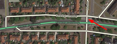
Example / see picture: Driving from left to right on the top street (A) with destination towards the east requires a reversal of driving direction. When the median segment B (red arrow) is 15 meters or less the app will navigate over the lower street towards the east. Only if this median segment is 16 meters or more the app will navigate over the bigger road in the middle (C).
See also the global page on Routing penalties/Controlling U-turn penalties