Geen bewerkingssamenvatting |
(Marked this version for translation) |
||
| Regel 2: | Regel 2: | ||
<languages /><translate> | <languages /><translate> | ||
==Non-drivable roads== | ==Non-drivable roads== <!--T:1--> | ||
The non-drivable [[Road types|road types]] are: | The non-drivable [[Road types|road types]] are: | ||
* [[Walking trail]] - Not able <sup>*</sup> to drive with a vehicle but with possible destinations. | * [[Walking trail]] - Not able <sup>*</sup> to drive with a vehicle but with possible destinations. | ||
| Regel 11: | Regel 11: | ||
<sup>*</sup> <small>''Not able'' means in this context ''not able'' or ''not allowed''. On many foot paths and bicycle paths it is physical possible to drive with a car or motor cycle, but these road types shouldn't be used by this type of traffic.</small> | <sup>*</sup> <small>''Not able'' means in this context ''not able'' or ''not allowed''. On many foot paths and bicycle paths it is physical possible to drive with a car or motor cycle, but these road types shouldn't be used by this type of traffic.</small> | ||
<!--T:2--> | |||
Page on the [[Non-drivable roads lock level|Locking level of non-drivable roads]].<br /> | Page on the [[Non-drivable roads lock level|Locking level of non-drivable roads]].<br /> | ||
<br /> | <br /> | ||
<!--T:3--> | |||
'''Belgium F99 sign'''<br /> | '''Belgium F99 sign'''<br /> | ||
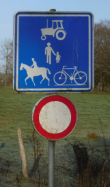
[[File:Non-routable-agricultural-vehicle.png|right|110px|Belgium F99 sign]] Belgium uses the F99 sign in a number of variants. The road is allowed for the type of traffic that is displayed on the sign. If this sign is used we've got the following mapping possibilities: | [[File:Non-routable-agricultural-vehicle.png|right|110px|Belgium F99 sign]] Belgium uses the F99 sign in a number of variants. The road is allowed for the type of traffic that is displayed on the sign. If this sign is used we've got the following mapping possibilities: | ||
| Regel 24: | Regel 26: | ||
<br /> | <br /> | ||
===Not or not always drivable=== | ===Not or not always drivable=== <!--T:4--> | ||
We often get the question "how do we map non-drivable or restricted access roads?" In the table below you will see what to do in every situation.<br /> | We often get the question "how do we map non-drivable or restricted access roads?" In the table below you will see what to do in every situation.<br /> | ||
<table width=90%> | <table width=90%> | ||
| Regel 37: | Regel 39: | ||
{{Clear}} | {{Clear}} | ||
===Walking Trail or Pedestrian Boardwalk=== | ===Walking Trail or Pedestrian Boardwalk=== <!--T:5--> | ||
'''Destination'''<br /> | '''Destination'''<br /> | ||
If a footpath leads from a normal road to a Walking Trail, but this path has no destinations / [[house numbers]], | If a footpath leads from a normal road to a Walking Trail, but this path has no destinations / [[house numbers]], | ||
| Regel 43: | Regel 45: | ||
Best use a WT, see picture below.<br /> | Best use a WT, see picture below.<br /> | ||
<!--T:6--> | |||
[[File:Routing-non-drivable.png|600px]] | [[File:Routing-non-drivable.png|600px]] | ||
<br /> | <br /> | ||
Versie van 8 aug 2018 23:33
Non-drivable roads
The non-drivable road types are:
- Walking trail - Not able * to drive with a vehicle but with possible destinations.
- Pedestrian Boardwalk - Not able * to drive with a vehicle and without destinations.
- Railroad
- Runway/Taxiway
* Not able means in this context not able or not allowed. On many foot paths and bicycle paths it is physical possible to drive with a car or motor cycle, but these road types shouldn't be used by this type of traffic.
Page on the Locking level of non-drivable roads.
Belgium F99 sign

Belgium uses the F99 sign in a number of variants. The road is allowed for the type of traffic that is displayed on the sign. If this sign is used we've got the following mapping possibilities:
- If there are houses or other destinations along the segment (house numbers), then a Private Road is used. Possibly to be completed with unpaved checked.
- If there are no destinations the road should be mapped as a Pedestrian Boardwalk.
- If necessary, the road can be divided into a part with habitation (Private Road) and a part without habitation (Pedestrian Boardwalk).
Use sparcely
Non-drivable roads like walking trails and pedestrian boardwalks shouldn't be added, unless there is a good reason. Check the Wiki pages on these road types: Walking trail and Pedestrian Boardwalk.
Not or not always drivable
We often get the question "how do we map non-drivable or restricted access roads?" In the table below you will see what to do in every situation.
| Road type | Description |
|---|---|
| Walking trail | Not able to drive with a vehicle Possible destination along the segment |
| Pedestrian Boardwalk | Not able to drive with a vehicle Does not have any destinations along the segment |
| Private road | Able to drive with a vehicle Not always allowed to drive with a car |
| Street with restriction | Access restricted for certain vehicle types Access restricted for certain hours of the day |
Walking Trail or Pedestrian Boardwalk
Destination
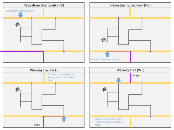
If a footpath leads from a normal road to a Walking Trail, but this path has no destinations / house numbers,
should it be defined as PB or is a PB skipped in the routing and should we take WT without house numbers?
Best use a WT, see picture below.

Public transport
The previous standard "Use Walking trails for public transport" is changed into "use Pedestrian Boardwalk for public transport". because both non-drivable roadtypes have now a fix. Preference for PB because public transport lanes shouldn’t have (by accident) destinations.
