(Created page with "<table align=right> <tr><td align=right>Freeway|<span style="color: black; background-color: #E6E6E6; border:1px solid #D8D8D8; padding-left: 10px; padding-right: 10px; bord...") |
(Updating to match new version of source page) |
||
| Regel 37: | Regel 37: | ||
|} | |} | ||
<br /> | <br /> | ||
* Railroads should be mapped uninterrupted. No junction nodes at city borders. | * Railroads should be mapped uninterrupted. No [[Nodes|junction nodes]] at city borders. | ||
* No connection to segments of any other road type besides Railroad! | * No connection to segments of any other road type besides Railroad! | ||
* No [[Street and City names|City name]] and a fixed [[Street and City names|Street name]]. | * No [[Street and City names|City name]] and a fixed [[Street and City names|Street name]]. | ||
Versie van 9 aug 2019 13:10
Spoorlijn
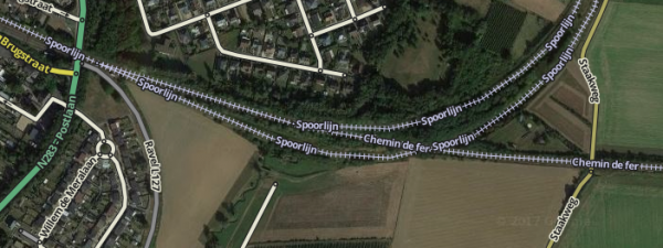
In de BeNeLux spoorlijnen, metros and trams zijn weergegeven via de Spoorlijn wegtype om een herkenningspunt te geven aan bestuurders.
Spoorlijnen die in de weg zitten of tussen twee wegen in worden niet getekend.
| Freeway |
| Major Highway |
| Minor Highway |
| Ramp |
| Primary Street |
| Street |
| Narrow street |
| Off-road |
| Parking Lot Road |
| Bestemmingsverkeer |
| Veerpont |
| Walking Trail |
| Pedestrian Boardwalk |
| Spoorlijn |
| Runway/Taxiway |
Attributes:
| Street | City | Lock | Elevation |
|---|---|---|---|
- Railroads should be mapped uninterrupted. No junction nodes at city borders.
- No connection to segments of any other road type besides Railroad!
- No City name and a fixed Street name.
- An elevation of -5. (Note: Due to a bug -5 isn't available, for now please use -4.)
For other means of public transport there are other guidelines, for instance pedestrian boardwalks used for public transport.
