Geen bewerkingssamenvatting |
Geen bewerkingssamenvatting |
||
| Regel 99: | Regel 99: | ||
===Photos tab=== | ===Photos tab=== | ||
Any photos which drivers have added to a Place will appear in the "Photos" tab. In [[Waze Map Editor|WME]], we can only view and delete photos. Photos can only be uploaded via the Waze app. Make a well thought-out decision about discarding a photo. Once a photo is deleted, it cannot be recovered. Delete only if the photo really is unclear, not helpful and/or inappropriate. For more guidelines on accepting or discarding photo's see the global Wiki page paragraph [https://wazeopedia.waze.com/wiki/Global/Places#Place_Updates_.28Moderation.29 Place Updates (Moderation)]. | Any photos which drivers have added to a Place will appear in the "Photos" tab. In [[Waze Map Editor|WME]], we can only view and delete photos. Photos can only be uploaded via the Waze app, via a [[Place update request|PUR]]. Make a well thought-out decision about discarding a photo. Once a photo is deleted, it cannot be recovered. Delete only if the photo really is unclear, not helpful and/or inappropriate. For more guidelines on accepting or discarding photo's see the global Wiki page paragraph [https://wazeopedia.waze.com/wiki/Global/Places#Place_Updates_.28Moderation.29 Place Updates (Moderation)]. | ||
==Lock Levels== | ==Lock Levels== | ||
Versie van 29 mei 2018 20:07
Places
Places are searchable destinations in the Waze map, just like the "Points of Interest" found in certain popular GPS devices. They can be added from the client, but also in the Waze Map Editor. Here you'll find the instructions on how to create a Place in the WME. For a description of the different types of places see the Place categories page.
A Place can be a Point or an Area. Above a given size Area Places become visible in the client. A Point Place is never visible, but both types can be searched and navigated to. There is also a third kind of Place called Residential, which are private addresses. These are always Point Places.
Point Places
Point Places don't show on the Wazers device. They can be used to help Wazers find locations, especially when they are not or wrongly listed in other destination search engines. As they are searchable from the app, accurate positioning of a point location and providing a full address (including street number) are both utterly important.
In the WME, a Point appears as a small circle:
![]() Standard point
Standard point
![]() Modified point, pending for approval
Modified point, pending for approval
The Waze routing server will navigate the Wazer onto the segment which is physically closest to where the Point is placed.
The Point Marker is the stop point. Typically, if the Place is inside a building, the marker should be located at or near the location's main entrance door. Try to imagine where you would stop to drop someone off for this location.
Area Places
Area Places appear in the Waze app. Too many of them can clutter the map, creating large gray zones that do not help Wazers orient themselves. Therefore, it is important to use Area Places only when they are distinctive and significant enough to orient drivers. Care should be taken not to snap to road segment nodes, because this makes it more difficult to edit the place and/or segments later on.
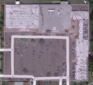
Area Places should have a minimum area size of 500 m2 (e.g., 10m x 50m) to be visible in the client's display. Most of the other places are Point Places. Gas Stations, and Parking Lots are always areas, regardless their size. They receive special handling. See also the paragraph on how to determine Area or Point.
Generally, an Area Place only covers what a Wazer sees when driving to the actual location. It follows that the Area outline covers the building of the place, but never the whole property. However, an Area Place doesn't have to be as detailed as the building is, actually, it's better to keep the shape roughly.
Natural features such as forests, parks, and lakes are drawn to the visible contours.
The different types of Area Places show in different colors in the app, as well as in WME. The colors vary slightly, depending on your display. Generally, Natural features show green (e.g., Park) or blue (e.g., River).

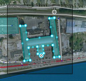
Each Area Place has a ![]() “Point Marker“ , which by default is centered. This point can be moved to where you should arrive, or where to park, even a short distance outside of the marked area, indicated by the black outline (see picture). Again, try to imagine where you would stop to drop someone off for this location.
“Point Marker“ , which by default is centered. This point can be moved to where you should arrive, or where to park, even a short distance outside of the marked area, indicated by the black outline (see picture). Again, try to imagine where you would stop to drop someone off for this location.
If the Area itself needs to be modified, click on the place to select it. Use the geometry points to adjust the shape. To move an area place without changing its shape, drag the ![]() Move Handle icon.
Move Handle icon.
Residential or Private Places
When arriving, Waze proposes to take a picture of your destination. In this way, many private Places are uploaded to WME. For these private Places, the category residential is used. Private Places will not be searchable, and the identity of whoever created them or attached pictures, will not be exposed. Private Places only contain photos and an exact address, without all the other properties of a Place. The pictures will only show to people driving explicitly to that address. Waze editors will be using the pictures and exact locations to improve the house numbers database.

Public Places can be turned into private Places, but private Places cannot be turned into public Places. Use the link located under the buttons for Point or Area in the menu, to convert Places mistakenly labeled as public into private.
More on this topic see the Residential Place page.
Combined Places

Point Places within an Area Place are allowed and mostly used for shops in a shopping mall, faculties within a University campus, etc.. Avoid Areas within Areas, as this may become confusing on the client's display.
When to use Area or Point
The area size covered by the visible contours is primarily used to determine whether to use a Point or Area type of Place. Recent testing shows that Area Places should be at least 500 m2 (that is, 50 meters in one dimension and 10 meters in the other) to show up in the app. Tests are still being run to find out the minimum size. Until these tests result in different findings, Area Places should have a minimum area size of 500 m2. Anyway, it doesn't make sense to create smaller areas, for they will not be visible in the client's display.
Exceptions to the minimum area size for the use of an Area Place, are Parking Lots and Gas Stations, which receive special handling and are to this moment always drawn as Areas.
All places are thus generally drawn as a Point Place, except when they are large and distinctive enough to help in the orientation during driving, which will often be the case with an Event Center, Factory, Hospital, Office, Camping, Shopping malls, Museums (e.g.,Rijksmuseum, Amsterdam), Monuments (e.g., Mardasson, Bastogne), Schools, Tourist Site, Attraction, Sports Court or Stadium. They are mapped as areas at the building outline and usually don't cover streets. Keep in mind the minimum area size for the decision to draw an Area instead of a Point. Every other destination, that is not a Parking Lot or a Gas Station, should be Points.
The table of categories also gives a guideline to choose between point and area places, according to their category, sub-category and probable area size.
Places details
Any Place - Point or Area - should contain as much information as possible.
General tab
The General tab for a Place is where you complete all of the basic information: categories, name, description, gas brand, residential/public, hours of operation, country, state, city, street and house number.
Category
- Places need at least one category to be assigned, but may belong to several others. Always choose the main category first. For example, a Gas Station may also be “Convenience Store”, “Car Wash”, or “Charging Station”. For a more detailed explanation of categories, see the Place categories page.
Name and address
- If possible, provide name and address. The naming of a Place should be done in the formal language of the location where the place is situated. Use the official name of the Place. In bi-lingual areas, use the alternate name. The address is especially useful to guide Wazers to the Place. Add other important information, such as brand (service stations) and opening times.
Description
- Beware not to use the Description field for notes to other editors. This field is visible in the Waze app, and should only contain details pertinent to the Place itself.
Entry / exit points
- Add, if necessary, Entry / exit points so Waze is able to navigate you to the right side of the place.
External providers
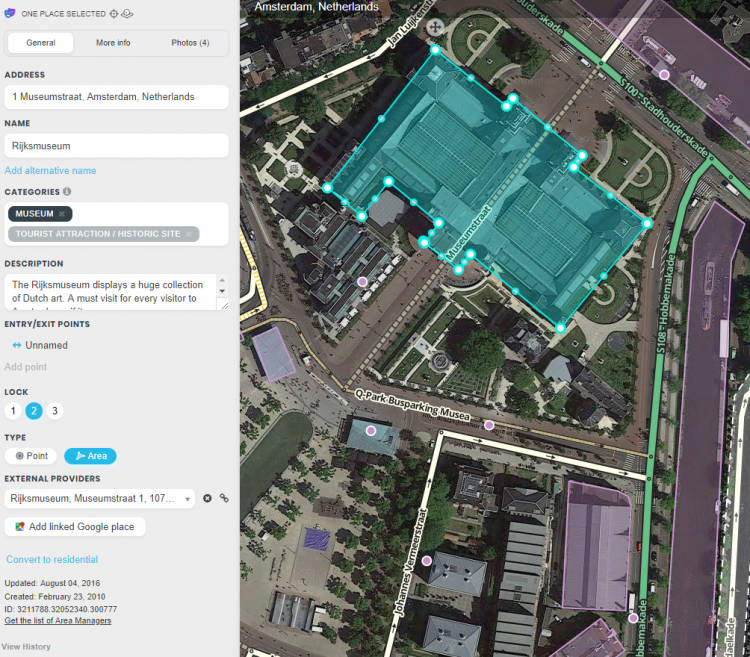
- Waze allows you to connect to POI from external providers. One of the providers is Google Maps. When a Place is linked, drivers can select any destination from search results in the app, whether the result is from Waze or Google, it will always lead you to the navigation stop point from Waze.
In the picture below you see an example from the Rijksmuseum in Amsterdam.

More Info tab
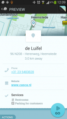
You can provide the website address and phone number in the “More Info” tab, where you can also select optional services, like Wifi, Toilets, Terrace or Parking for customers (not to be drawn separately!). Information in this tab are shown in the search results. From there you can click the website address or telephone number and activate your browser or phone function. Therefore, they should be in a usable format:

Website
- The website address is best written as www.adress.extension, like www.casca.nl. Leave out http:// or https://.
Telephone
- Telephone numbers should best be written in international format: Generally, the number consists of the land code, followed by the area code (without 0), and than the subscribers number, all without dashes, slashes, and the like.
- Belgium:
- +32 AA BB BB BB, or +32 A BBB BB BB for landlines,
- +32 4AA BB BB BB or +32 4AA BBB BBB for mobile numbers
- Netherlands:
- +31 AA BBBBBBBB, or +31 AAA BBBBBBB for landlines,
- +31 6 CBBBBBBB for mobile numbers
- Luxembourg:
- +352 local number (varies in amount of numbers and areas)
Opening hours
- Add if possible the opening hours.
Photos tab
Any photos which drivers have added to a Place will appear in the "Photos" tab. In WME, we can only view and delete photos. Photos can only be uploaded via the Waze app, via a PUR. Make a well thought-out decision about discarding a photo. Once a photo is deleted, it cannot be recovered. Delete only if the photo really is unclear, not helpful and/or inappropriate. For more guidelines on accepting or discarding photo's see the global Wiki page paragraph Place Updates (Moderation).
Lock Levels
Please consider that places that are fundamental to the functioning of Waze, such as Parking Lots, should be locked at least to Level 2 (or higher), to prevent loss of data due to automatic acceptance of submissions. See also the page on Place categories.