Geen bewerkingssamenvatting |
Geen bewerkingssamenvatting |
||
| Regel 8: | Regel 8: | ||
As a general rule: CADO's are not mapped. The exceptions that are mapped are protected by long lasting [[Closures|closures]].<br /> | As a general rule: CADO's are not mapped. The exceptions that are mapped are protected by long lasting [[Closures|closures]].<br /> | ||
<br /> | <br /> | ||
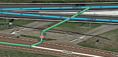
Some CADO's are mapped. These are mostly lanes that can be opened for the public in case of an accident blocking the regular road. An example on the N59, Ooltgensplaat | Some CADO's are mapped. These are mostly lanes that can be opened for the public in case of an accident blocking the regular road. An example on the N59, Ooltgensplaat. | ||
[[File:Cado-ooltgensplaat.png|400px|left|CADO Ooltgensplaat]] | [[File:Cado-ooltgensplaat.png|400px|left|CADO Ooltgensplaat]] | ||
</translate> | |||
{{Clear}} | {{Clear}} | ||
__NOTOC__ | __NOTOC__ | ||
{{Bottomline}} | {{Bottomline}} | ||
Versie van 30 mei 2018 19:28
CADO

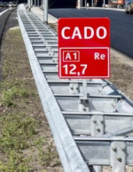
In the Netherlands we have the phenomenon CADO, which stands for Calamiteiten doorsteek .
Pass throughs that can be opened to emergency services.
As a general rule: CADO's are not mapped. The exceptions that are mapped are protected by long lasting closures.
Some CADO's are mapped. These are mostly lanes that can be opened for the public in case of an accident blocking the regular road. An example on the N59, Ooltgensplaat.
