Geen bewerkingssamenvatting |
Geen bewerkingssamenvatting |
||
| (15 tussenliggende versies door 2 gebruikers niet weergegeven) | |||
| Regel 1: | Regel 1: | ||
{{TopLine}} | |||
<languages /> | |||
==CADO== | |||
[[File:Cado-sign.png|right|150px]] | |||
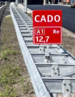
In the Netherlands we have the phenomenon <i>CADO</i>, which stands for <i>Calamiteiten doorsteek </i>. | |||
Pass throughs that can be opened to emergency services. <br /> | |||
<br /> | |||
As a general rule: CADO's are not mapped. The exceptions that are mapped are protected by long lasting [[Closures|closures]].<br /> | |||
<br /> | |||
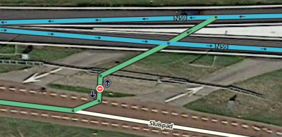
Some CADO's are mapped. These are mostly lanes that can be opened for the public in case of an accident blocking the regular road. An example on the N59, Ooltgensplaat. | |||
The closed segment is tilted to prevent the closure to be applied to one of Google Maps nearby segments. | |||
[[File:Cado-ooltgensplaat.png|400px|left|CADO Ooltgensplaat]] | |||
{{Clear}} | |||
__NOTOC__ | |||
{{Bottomline}} | |||
Huidige versie van 13 sep 2020 om 09:00
CADO

In the Netherlands we have the phenomenon CADO, which stands for Calamiteiten doorsteek .
Pass throughs that can be opened to emergency services.
As a general rule: CADO's are not mapped. The exceptions that are mapped are protected by long lasting closures.
Some CADO's are mapped. These are mostly lanes that can be opened for the public in case of an accident blocking the regular road. An example on the N59, Ooltgensplaat.
The closed segment is tilted to prevent the closure to be applied to one of Google Maps nearby segments.
