(Changed the naming specification) |
No edit summary |
||
| Line 14: | Line 14: | ||
=== Naming === | === Naming === | ||
The standard naming structure for an IEA at mile marker 325 would be “Exit 325”. If more than one exit exists within the same mile span, they should be named “Exit 325A” and “Exit 325B” (or differently of other naming structures are in place for such a situation). The street the exit terminates at should not be included in the name unless it alleviates confusion (ie “Exit 449 - 72nd Street”). | The standard naming structure for an IEA at mile marker 325 would be “Exit 325”. If more than one exit exists within the same mile span, they should be named “Exit 325A” and “Exit 325B” (or differently of other naming structures are in place for such a situation). The street the exit terminates at should not be included in the name unless it alleviates confusion or no numbering system is in place (ie “Exit 449 - 72nd Street”). | ||
=== Metadata === | === Metadata === | ||
Revision as of 21:30, 26 January 2019
When driving on an interstate, it is useful knowing where you are and what exits are coming up. To that end, one solution to this for Waze is to create an area place dedicated to said exit displaying in-app. These exits are conceivably usable for navigation, but serve the primary function of giving users an at-a-glance view of upcoming junctions as they travel, possibly before an exit sign has even come into view.
Standards
In the creation of an Interstate Exit Area Place (IEA), the following standards are to be observed:
Drawing
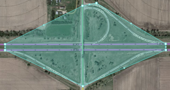
The shape of the IEA shall be drawn to include the entirety of the outermost ramp segment, fitted to their shape. This gives the most precise shape of the exit.
 |
 |
Naming
The standard naming structure for an IEA at mile marker 325 would be “Exit 325”. If more than one exit exists within the same mile span, they should be named “Exit 325A” and “Exit 325B” (or differently of other naming structures are in place for such a situation). The street the exit terminates at should not be included in the name unless it alleviates confusion or no numbering system is in place (ie “Exit 449 - 72nd Street”).
Metadata
An interstate exit area place should follow the following standards for metadata:
- Street Address: No House Number; Street, City, and State set to the same as the freeway segments contained in the area
- Primary Category: Junction/Intersection
- Lock Level: Equal to the freeway segments contained in the area
Routing Based Information
Information commonly used for navigable places such as Photos, Descriptions, etc. are not necessary, but can be added at the discretion of the editing team.