< States
(Page creation) |
mNo edit summary |
||
| (6 intermediate revisions by 2 users not shown) | |||
| Line 1: | Line 1: | ||
{{ | {{IN Tabs}} | ||
<div style="border:thin solid lightblue"> | |||
<p style="margin:0;padding:2px;background:#B0E2FF;border:thin solid lightblue;font-weight:bold;font-size:150%"> | |||
Karnataka</p></div> | |||
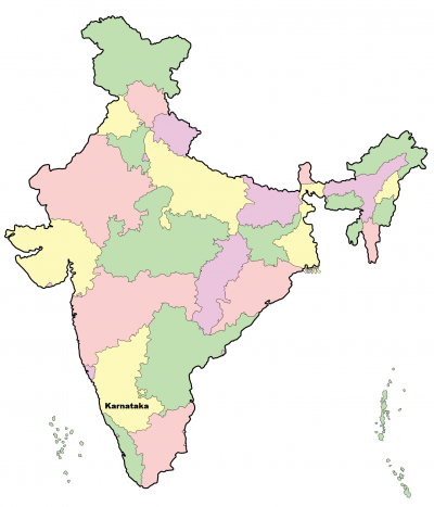
[[File:StateKarnataka.png|right|400px]] | |||
Karnataka is one of the [[States|states]] in the south-west of India. | |||
===Road data=== | |||
{{ | all under embargo of [[Copyright|copyright]]! | ||
* https://www.karnataka.gov.in/English | |||
* http://www.indiarealestateforums.com/media/kunena/attachments/1148/bbmp_zones.pdf | |||
===Tools=== | |||
* [https://wmebr.info/ur/urs_on_cities.php?state=Karnataka&country=India Open Map Issues (URs) in India - Karnataka] | |||
===Speed Limits=== | |||
{| border="1" class="wikitable" | |||
!colspan="4" bgcolor="#387fb8"|Default speed limits in km/h (kmp) | |||
|- style="text-align: center;" | |||
|road type | |||
|Karnataka | |||
|- | |||
| Freeway|| 120 | |||
|- | |||
| Two-lane highway || 100 | |||
|- | |||
| One-lane highway (most mH) || 60 | |||
|- | |||
| other rural roads || 60 | |||
|- | |||
| other urban roads || 40 | |||
|} | |||
Updated 2017 | |||
===Karnataka divisions=== | |||
The Indian State of Karnataka is divided into 4 main regions, which in turn are divided into administrative districts, as [https://en.wikipedia.org/wiki/List_of_districts_of_Karnataka#Administrative_divisions listed in the wiki]. The districts are further divided into sub-districts (Taluka)<br /> | |||
<div style="text-align: right; direction: ltr; margin-left: 1em;">[[#TOC|<small>''back to the table of content''</small>]]</div> | |||
=====Bengaluru region===== | |||
'''districts:''' | |||
# Bengaluru Urban | |||
# Bengaluru Rural | |||
# Chikkaballapur | |||
# Chitradurga | |||
# Davanagere | |||
# Kolar | |||
# Ramanagara | |||
# Shivamogga | |||
# Tumakuru | |||
=====Bengaluru city===== | |||
Zones: [http://218.248.45.169/download/map/zones.pdf map] | |||
# WEST | |||
# SOUTH | |||
# RAJARAJESWARI NAGAR | |||
# MAHADEVAPURA | |||
# EAST | |||
# DASARAHALLI | |||
# YELAHANKA | |||
# BOMMANAHALLI | |||
*Note that in Google Maps Bengaluru is different from Bengaluru Urban | |||
<!-- | |||
=====Road data===== | |||
all under embargo of copyright! | |||
* http://www.mapsofindia.com/maps/karnataka/bangalore-city-zone-map.html | |||
* http://www.clearvalue.in/cdp/cdpMap.html?Loc=BlrCore# (from: http://harshasagar.com/2014/01/18/bda-bmrda-bangalore-cdp-maps-free-online-access-at-www-clearvalue-in/ | |||
* http://bengaluruurban.nic.in/ | |||
* https://en.wikipedia.org/wiki/Greater_Bangalore | |||
* wards: http://www.vigeyegpms.in/bbmp/?module=public&action=wards | |||
--> | |||
{{Clear}} | |||
Latest revision as of 11:40, 30 October 2019
Karnataka

Karnataka is one of the states in the south-west of India.
Road data
all under embargo of copyright!
- https://www.karnataka.gov.in/English
- http://www.indiarealestateforums.com/media/kunena/attachments/1148/bbmp_zones.pdf
Tools
Speed Limits
| Default speed limits in km/h (kmp) | |||
|---|---|---|---|
| road type | Karnataka | ||
| Freeway | 120 | ||
| Two-lane highway | 100 | ||
| One-lane highway (most mH) | 60 | ||
| other rural roads | 60 | ||
| other urban roads | 40 | ||
Updated 2017
Karnataka divisions
The Indian State of Karnataka is divided into 4 main regions, which in turn are divided into administrative districts, as listed in the wiki. The districts are further divided into sub-districts (Taluka)
Bengaluru region
districts:
- Bengaluru Urban
- Bengaluru Rural
- Chikkaballapur
- Chitradurga
- Davanagere
- Kolar
- Ramanagara
- Shivamogga
- Tumakuru
Bengaluru city
Zones: map
- WEST
- SOUTH
- RAJARAJESWARI NAGAR
- MAHADEVAPURA
- EAST
- DASARAHALLI
- YELAHANKA
- BOMMANAHALLI
- Note that in Google Maps Bengaluru is different from Bengaluru Urban