(adding relation sat view and Waze map) |
m (added pic to locked segments) |
||
| (4 intermediate revisions by the same user not shown) | |||
| Line 18: | Line 18: | ||
{{TOC}}<br /> | {{TOC}}<br /> | ||
=Waze is not a map, but a navigation system= | ==Waze is not a map, but a navigation system== | ||
Most mistakes are because of a misunderstanding of the overall goal: 'Waze is not a topographic map, but a navigation tool'. Many starting editors try to make the map in Waze an exact copy of the actual situation. Roads are divided; walking trails are added; perfect rounded corners and area places are exactly drawn. The actual goal of Waze is to get the best routing instructions. The lesser detail on the map, the easier and faster a map can be interpreted during driving, especially on small smartphone screens. <br /> | Most mistakes are because of a misunderstanding of the overall goal: 'Waze is not a topographic map, but a navigation tool'. Many starting editors try to make the map in Waze an exact copy of the actual situation. Roads are divided; walking trails are added; perfect rounded corners and area places are exactly drawn. The actual goal of Waze is to get the best routing instructions. The lesser detail on the map, the easier and faster a map can be interpreted during driving, especially on small smartphone screens. <br /> | ||
<br /> | <br /> | ||
| Line 25: | Line 25: | ||
To help you Waze has created a number guidelines. That is what this page is about. | To help you Waze has created a number guidelines. That is what this page is about. | ||
==Editing errors are inevitable== | ===Editing errors are inevitable=== | ||
Everybody, without the need of any prior knowledge or practice, can start editing the Waze map. Therefore, Waze accepts the risk that users make edits that seems logical to them, but lead to undesired results. The Waze community is enthousiastic and active, so the mistake will often quickly be noticed. A more experienced editor will contact you to correct the mistake or do the correction himself. Don't take it as criticism, but an encouragement to learn more about editing. | Everybody, without the need of any prior knowledge or practice, can start editing the Waze map. Therefore, Waze accepts the risk that users make edits that seems logical to them, but lead to undesired results. The Waze community is enthousiastic and active, so the mistake will often quickly be noticed. A more experienced editor will contact you to correct the mistake or do the correction himself. Don't take it as criticism, but an encouragement to learn more about editing. | ||
Errors are often the result of a misunderstood or unknown guideline, or a lack of technical knowledge, and cannot be really viewed as a fault. In fact, there is only one true "mistake" you can make, which is withholding from communication with other editors. | Errors are often the result of a misunderstood or unknown guideline, or a lack of technical knowledge, and cannot be really viewed as a fault. In fact, there is only one true "mistake" you can make, which is withholding from communication with other editors. | ||
==Make sure that other editors can contact you== | ===Make sure that other editors can contact you=== | ||
The only true mistake you can make as an editor, is being unreachable to other editors. If editors spot your edits with an undesired result, or if they don't understand the reason why you made this edit, they will try to contact you. They want to increase the quality of the map and at the same time help you to become a better editor. If other editors cannot reach you, they cannot help you! Moreover, they will probably change your edits according to their own interpretation of the situation. | The only true mistake you can make as an editor, is being unreachable to other editors. If editors spot your edits with an undesired result, or if they don't understand the reason why you made this edit, they will try to contact you. They want to increase the quality of the map and at the same time help you to become a better editor. If other editors cannot reach you, they cannot help you! Moreover, they will probably change your edits according to their own interpretation of the situation. | ||
| Line 38: | Line 38: | ||
<div style="text-align: right; direction: ltr; margin-left: 1em;"><small>[[#TOC|''go back to the table of content'']] or [[#TOP|''back to the top'']]</small></div> | <div style="text-align: right; direction: ltr; margin-left: 1em;"><small>[[#TOC|''go back to the table of content'']] or [[#TOP|''back to the top'']]</small></div> | ||
==Basic principles of Waze== | ===Basic principles of Waze=== | ||
Because Waze is a navigation tool and not a topographic map, some things may be drawn differently than expected. Waze is developed for drivers of cars and should not be used for other means of transportation like pedestrians, pedal cyclists, public transport, or commercial transport. Also, Waze is not meant to include your personal favorite places, historic railways and illegal shortcuts. While editing, keep in mind the following 3 principles: | Because Waze is a navigation tool and not a topographic map, some things may be drawn differently than expected. Waze is developed for drivers of cars and should not be used for other means of transportation like pedestrians, pedal cyclists, public transport, or commercial transport. Also, Waze is not meant to include your personal favorite places, historic railways and illegal shortcuts. While editing, keep in mind the following 3 principles: | ||
===Usability=== | ====Usability==== | ||
When it comes to the map, the first and foremost goal of editing is to provide the driver with a map that is easy to follow on a small display, and to produce sensible verbal instructions when (and only when) they are needed. | When it comes to the map, the first and foremost goal of editing is to provide the driver with a map that is easy to follow on a small display, and to produce sensible verbal instructions when (and only when) they are needed. | ||
===Simplicity=== | ====Simplicity==== | ||
*It is not a goal to model the physical roadway lane-by-lane. Doing so often leads to unnecessary complexity--which means a cluttered map, confusing verbal directions, and lots and lots (and lots!) of extra map maintenance. | *It is not a goal to model the physical roadway lane-by-lane. Doing so often leads to unnecessary complexity--which means a cluttered map, confusing verbal directions, and lots and lots (and lots!) of extra map maintenance. | ||
* Do '''NOT''' map every road you see. Waze is meant for car drivers. If a road is not accessible to cars, it often is not useful to draw this in Waze. Pedestrian area's are usually only drawn if they are useful for navigational purposes. When in doubt, [[Community|contact]] a more experienced editor. | * Do '''NOT''' map every road you see. Waze is meant for car drivers. If a road is not accessible to cars, it often is not useful to draw this in Waze. Pedestrian area's are usually only drawn if they are useful for navigational purposes. When in doubt, [[Community|contact]] a more experienced editor. | ||
===Retention=== | ====Retention==== | ||
* As a result of people driving with Waze on, road segments retain certain information (e.g., average speed) that is used in route optimization. When a segment is deleted, that information is deleted too. Given a choice between deleting a tangle of segments and creating new ones, or untangling them and reusing them, it is often better to "recycle". | * As a result of people driving with Waze on, road segments retain certain information (e.g., average speed) that is used in route optimization. When a segment is deleted, that information is deleted too. Given a choice between deleting a tangle of segments and creating new ones, or untangling them and reusing them, it is often better to "recycle". | ||
* Does the area look different on the satellite view than the roads show? Check if the roads have been recently updated before changing it - satellite imagery might not be up te date. | * Does the area look different on the satellite view than the roads show? Check if the roads have been recently updated before changing it - satellite imagery might not be up te date. | ||
| Line 87: | Line 87: | ||
====Turn instructions Overrides==== | ====Turn instructions Overrides==== | ||
to | If the default turn instructions are not clear, you can use a <i>Turn Instruction Override (TIO)</i>. A TIO allows editors to manually set a turn arrow to give a non-default text and verbal instruction to the driver making that turn through a junction. | ||
*Hoover over the arrow, and change the voice prompt n the popup box. | |||
However, use it it sparsely and only if needed. Otherwise it is just adding extra load to the engine and it clutters WME as well. Advanced info on how Waze determines instructions can be found in the global page on [https://wazeopedia.waze.com/wiki/Global/How_Waze_determines_turn_/_keep_/_exit_maneuvers turns, keeps and exits]. | |||
<div style="text-align: right; direction: ltr; margin-left: 1em;">[[#TOC|<small>''go back to the table of content''</small>]]</div> | <div style="text-align: right; direction: ltr; margin-left: 1em;">[[#TOC|<small>''go back to the table of content''</small>]]</div> | ||
===Disconnected segments=== | |||
Even when segments appear to be connected on your screen, it does not necessarily mean they actually are properly connected. The fastest way to check this is to select one of the segments. When you don't see the Junction Arrow(s) light up, it is not connected. | |||
[[File:Failed attach shown.png|left|thumb|super|No visible arrows, thus not connected. The selected road will be handled as a dead-end road.]] | |||
[[File:Failed attach fixed.png|thumb|super|You see the arrows, thus the roads are connected.]] | |||
<br /> | |||
When a road should be connected, please check the [[Quick_start_guide#Junction_Arrows|Junction Arrows]]. If it is not connected, move the end node away from where it should connect, and drop it somewhere else. Than pick it up again and drag it to where you want the junction to be. WME now automatically creates a junction. Again, check the [[Quick_start_guide#Junction_Arrows|Junction Arrows]]. | |||
If you cannot connect a segment using the above described method, one of the segments could have a lock level higher than your editing level. In that case you cannot solve this functional mistake yourself and you might want to ask for an [[#Locked_segments|unlock]]. If the segment is a pedestrian boardwalk, check whether this segment should be connected anyway. If you are unable to connect the segment and cannot get a hold of a more senior editor that can make the connection, leave a gap between the 2 segments. That way it is clear to other editors that this segment still needs to be connected. If you place it onto the other segment it will look ok at first glance but routing instructions will not function properly. | |||
<div style="clear: both"></div> | |||
<div style="text-align: right; direction: ltr; margin-left: 1em;"><small>[[#TOC|''go back to the table of content'']] or [[#TOP|''back to the top'']]</small></div> | |||
===Locked segments=== | |||
[[File:WME Locked segment.png|right|sub]] | |||
To protect the map from unwanted errors, some segments are secured with a lock. Important main roads will show higher locks than small side streets. Locked roads can only be changed by editors with a rank the same or higher than the lock level. Even if you succeed to edit such a segment, you won't be able to save your changes. Also, you will not be able to connect other roads to locked roads. If you try to do that, it will result in [[#Disconnected segments|disconnected segments]], like described in the previous paragraph.<br /> | |||
When you want to change a segment with a higher lock level than your own rank, propose your changes to a higher rank editor, or ask a temporary decrease in lock level. You always need to make a [[Editing/Quickstart#Permalinks|permalink]], and specify the region or city, and the needed rank. | |||
to | |||
== | Use one of the following methods: | ||
* Use the appropriate [[Slack|Slack editing]] channel. | |||
* Use a private message (DM or PM, in Slack or forum) to ask the last editor, who is visible at the bottom left of your screen when selecting the segment. If you do not get a response, you can also ask the Area manager or one of the Local Champs of your country instead. | |||
* Place your request in the subforum for [https://www.waze.com/forum/viewforum.php?f=561 Unlock requests in India]. | |||
<div style="clear: both"></div> | |||
<div style="text-align: right; direction: ltr; margin-left: 1em;"><small>[[#TOC|''go back to the table of content'']] or [[#TOP|''back to the top'']]</small></div> | <div style="text-align: right; direction: ltr; margin-left: 1em;"><small>[[#TOC|''go back to the table of content'']] or [[#TOP|''back to the top'']]</small></div> | ||
| Line 146: | Line 160: | ||
<div style="clear: both"></div> | <div style="clear: both"></div> | ||
<div style="text-align: right; direction: ltr; margin-left: 1em;">[[#toc|<small>''back to the Table of Content''</small>]]</div> | <div style="text-align: right; direction: ltr; margin-left: 1em;">[[#toc|<small>''back to the Table of Content''</small>]]</div> | ||
<div style="text-align: right; direction: ltr; margin-left: 1em;"><small>[[#TOC|''go back to the table of content'']] or [[#TOP|''back to the top'']]</small></div> | <div style="text-align: right; direction: ltr; margin-left: 1em;"><small>[[#TOC|''go back to the table of content'']] or [[#TOP|''back to the top'']]</small></div> | ||
Latest revision as of 13:02, 26 January 2020
Improve your skills
| This part of the Indian wiki is under construction. |
This Wiki page is not supposed to be a full manual of how to edit the Waze Map. It is an overview of subjects that are often confusing for starting editors, because they do not know the guidelines yet and their own logic tells them differently. This is not surprising because many of the guidelines have changed over the years and if you don't know the history, you don't always see the logic. All (starting) editors had this issue. And because guidelines are still changing and will keep changing, this will also happen to more experienced editors. In addition, the technical working of Waze changes often.
On this Wiki page, we have tried to combine technical knowledge of Waze with the users guidelines in India. It is a helpful tool for senior editors to refer to when explaining the concepts to starting editors. To keep duplicate texts to a minimum, we also refer to other Wiki pages [disclaimer].
Like in real life, also in Waze things are not always black and white. That is why we say we don't have rules or regulations, but guidelines. Exceptions to guidelines are always possible and not a problem, provided you have good arguments.
The best advice we can give to starting editors is to just start. Pick a topic that is of interest to you and practice the guidelines. If anything is unclear, just ask your community.
Most mistakes are because of a misunderstanding of the overall goal: 'Waze is not a topographic map, but a navigation tool'. Many starting editors try to make the map in Waze an exact copy of the actual situation. Roads are divided; walking trails are added; perfect rounded corners and area places are exactly drawn. The actual goal of Waze is to get the best routing instructions. The lesser detail on the map, the easier and faster a map can be interpreted during driving, especially on small smartphone screens.
Another reason to keep the detail as few as possible is speed. The lesser details, the lesser bandwidth the downloading of the map requires. Also the lesser junctions there are, the faster the route calculation is. The number of junctions that Waze can handle in one route is limited. So keeping the number of junctions as low as possible, especially on longer routes.
To help you Waze has created a number guidelines. That is what this page is about.
Editing errors are inevitable
Everybody, without the need of any prior knowledge or practice, can start editing the Waze map. Therefore, Waze accepts the risk that users make edits that seems logical to them, but lead to undesired results. The Waze community is enthousiastic and active, so the mistake will often quickly be noticed. A more experienced editor will contact you to correct the mistake or do the correction himself. Don't take it as criticism, but an encouragement to learn more about editing.
Errors are often the result of a misunderstood or unknown guideline, or a lack of technical knowledge, and cannot be really viewed as a fault. In fact, there is only one true "mistake" you can make, which is withholding from communication with other editors.
Make sure that other editors can contact you
The only true mistake you can make as an editor, is being unreachable to other editors. If editors spot your edits with an undesired result, or if they don't understand the reason why you made this edit, they will try to contact you. They want to increase the quality of the map and at the same time help you to become a better editor. If other editors cannot reach you, they cannot help you! Moreover, they will probably change your edits according to their own interpretation of the situation.
Therefore, make sure that you can receive e-mails from Waze by providing a valid mail address. Check your mailbox regularly. Also check whether e-mails from Waze are not delivered to your spam- or junkfolder. You might want to make a filter to move the e-mails from Waze to a specific folder, or even create a separate mailbox for Waze. If needed, adjust your Waze settings. See the extended info about communication tools.
You might also want to get in touch with your community and get to know the Area Managers in your neighbourhood (link) who have shown good editing skills and have been allocated a specific area to look after.
Basic principles of Waze
Because Waze is a navigation tool and not a topographic map, some things may be drawn differently than expected. Waze is developed for drivers of cars and should not be used for other means of transportation like pedestrians, pedal cyclists, public transport, or commercial transport. Also, Waze is not meant to include your personal favorite places, historic railways and illegal shortcuts. While editing, keep in mind the following 3 principles:
Usability
When it comes to the map, the first and foremost goal of editing is to provide the driver with a map that is easy to follow on a small display, and to produce sensible verbal instructions when (and only when) they are needed.
Simplicity
- It is not a goal to model the physical roadway lane-by-lane. Doing so often leads to unnecessary complexity--which means a cluttered map, confusing verbal directions, and lots and lots (and lots!) of extra map maintenance.
- Do NOT map every road you see. Waze is meant for car drivers. If a road is not accessible to cars, it often is not useful to draw this in Waze. Pedestrian area's are usually only drawn if they are useful for navigational purposes. When in doubt, contact a more experienced editor.
Retention
- As a result of people driving with Waze on, road segments retain certain information (e.g., average speed) that is used in route optimization. When a segment is deleted, that information is deleted too. Given a choice between deleting a tangle of segments and creating new ones, or untangling them and reusing them, it is often better to "recycle".
- Does the area look different on the satellite view than the roads show? Check if the roads have been recently updated before changing it - satellite imagery might not be up te date.
- Are you working in an area which has been edited recently? Remember that this has been done by other editors who have invested their time trying to make the roads and cities as accurate as possible, so please be careful before changing others' work. Rather contact the editor first and discuss the changes.
Common functional problems
Incorrect or incomplete data can have a negative effect on the navigation or even make it impossible to navigate to a specific location. We call these functional mistakes and they should be corrected as soon as possible. Functional mistakes are, if noticed by an other editor, often directly corrected because of the great impact to the functionality of the App.
Unnamed roads
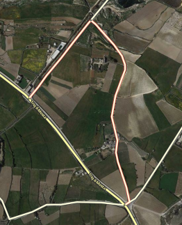
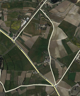
When a road does not have a city- or street name, it will get a red outline in WME and it won't be used for navigation. These roads can originate from
- Paving roads, that are not confirmed in WME
- an editor added a road, but forgot to give it a name
Fill in the city and street name by selecting the segment, than click
in the top left of the menu. If you don't know the name of the street or the city, check None.
Before you delete a segment, first consult the editor who added it. If you think the segment is an improvement to the map, fill in the missing data. Also check the junction arrows; when an editor has forgotten to fill in the name, probably the junction arrows are not set either.
Read more information about how to create a road.
Junction Arrows (JA)
Junction Arrows are the red, green en orange arrows when you select a segment. They control which turns are allowed. Green is allowed, red is not allowed and orange is partially restricted. You can also restrict entrance based on vehicle type but this feature is not yet functional in the routing calculation. Junction Arrows are the red, green en orange arrows when you select a segment. They control which turns are allowed. Green is allowed, red is not allowed and orange is |partially restricted. Restrictions can be set in time, vehicle type or passes if applicable.
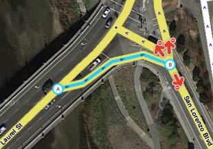
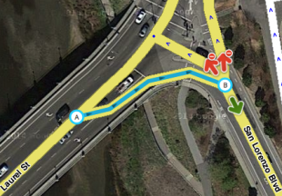
When you change the driving direction of a segment always remember to check the junction arrows. The WME does not adjust them automatically based on the driving direction. The quickest way to correct hem is to select the junction and press q and w or click on the button 'Allow all turns'. When creating a new road by default all JA's are red. In the advanced settings of the editor check the option 'Draw new roads with all turns allowed'. If you select this option, it is advised to also check the option 'Draw new roads as two-way'.
An easy way to check incorrect red junction arrows is Shift-Z. This will show all the red arrows in the area on your screen, also for the not selected segments. Of course these are not all incorrect, but you can check them. It is advised to before you do the correction, you press Shift-Z again and select the segment with the red arrow. Otherwise you can not see which segment has the red arrow.
Turn instructions Overrides
If the default turn instructions are not clear, you can use a Turn Instruction Override (TIO). A TIO allows editors to manually set a turn arrow to give a non-default text and verbal instruction to the driver making that turn through a junction.
- Hoover over the arrow, and change the voice prompt n the popup box.
However, use it it sparsely and only if needed. Otherwise it is just adding extra load to the engine and it clutters WME as well. Advanced info on how Waze determines instructions can be found in the global page on turns, keeps and exits.
Disconnected segments
Even when segments appear to be connected on your screen, it does not necessarily mean they actually are properly connected. The fastest way to check this is to select one of the segments. When you don't see the Junction Arrow(s) light up, it is not connected.


When a road should be connected, please check the Junction Arrows. If it is not connected, move the end node away from where it should connect, and drop it somewhere else. Than pick it up again and drag it to where you want the junction to be. WME now automatically creates a junction. Again, check the Junction Arrows.
If you cannot connect a segment using the above described method, one of the segments could have a lock level higher than your editing level. In that case you cannot solve this functional mistake yourself and you might want to ask for an unlock. If the segment is a pedestrian boardwalk, check whether this segment should be connected anyway. If you are unable to connect the segment and cannot get a hold of a more senior editor that can make the connection, leave a gap between the 2 segments. That way it is clear to other editors that this segment still needs to be connected. If you place it onto the other segment it will look ok at first glance but routing instructions will not function properly.
Locked segments

To protect the map from unwanted errors, some segments are secured with a lock. Important main roads will show higher locks than small side streets. Locked roads can only be changed by editors with a rank the same or higher than the lock level. Even if you succeed to edit such a segment, you won't be able to save your changes. Also, you will not be able to connect other roads to locked roads. If you try to do that, it will result in disconnected segments, like described in the previous paragraph.
When you want to change a segment with a higher lock level than your own rank, propose your changes to a higher rank editor, or ask a temporary decrease in lock level. You always need to make a permalink, and specify the region or city, and the needed rank.
Use one of the following methods:
- Use the appropriate Slack editing channel.
- Use a private message (DM or PM, in Slack or forum) to ask the last editor, who is visible at the bottom left of your screen when selecting the segment. If you do not get a response, you can also ask the Area manager or one of the Local Champs of your country instead.
- Place your request in the subforum for Unlock requests in India.
Incorrect use of roundabouts
to be added
Private access roads that distort routing
to be added
Local agreements (that are not logical at first glance)
to be added
The relation between the satellite view and map

The satellite view may be outdated or doesn´t show everything. For example, a road in a forest is probably not visible on the satellite view. Thus, use the satellite view as a source, not as a goal to copy. In case the road is mapped differently, please consult the previous editor or the area manager. It is recommended to add a Map Comment (MC) in such situations.
Many examples can be found on our KISS page.
Too many geometry nodes
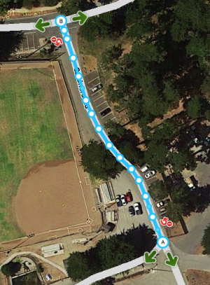
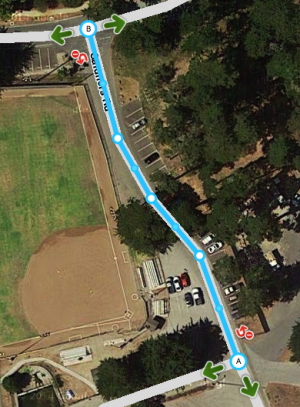
Too many geometry points can slow down the build of your screen. Also, it is harder to maintain the map. Therefore, we use as few nodes as possible, even if that means that a road in Waze does not exactly follow the road in the Satellite View. If a segment has too many nodes, please remove them by hovering your mouse over the nodes, and press d.
-
too many geometry nodes
-
this gives fine navigation instructions
-
alternative, if round corners are wished for
For more information see the Changing elements on the map paragraph in the Quick Start Guide.
Simplify an intersection


Starting editors often tend to draw the map exactly like the satellite view shows. However, the Waze map should be as simple as possible, in a way that yield the best navigation instructions, with a clear and simple map on screen. This implies that sometimes roads or parts of roads are even not drawn, or drawn differently from the satellite view.
As the examples show, when you draw the roads exactly like the actual situation (picture left) you will end up with lots of segments and junctions. This will result in a lot of maintenance, cluttered screen and database load. In addition, the driver receives many unnecessary navigation instructions that can be confusing. Simplified mapping (picture right) yields only one navigation instruction, with an easy and quickly readable map on a small screen.
More examples of drawing complex situations can be found on the KISS page.
Road types
to be added
Freeway / Highway
to be added
Pedestrian boardwalks
to be added
Parking Lots
to be added
Splitting up roads
Undividing
to be added
Update request (UR)
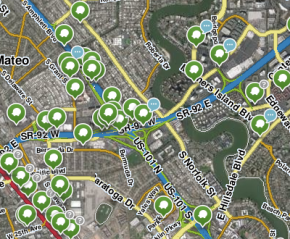
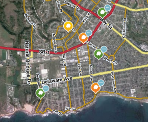
While driving, a driver can report a problem by submitting an Update Request (UR). Often there is not enough time to fully describe the issue. Therefore, Waze developed the possibility to start a conversation in the UR. Whenever you respond to an UR, you should do this with care and attention. The user does not report if he or she doesn't encounter a problem! It is your task to solve the problem as best as you can, or find the help needed to solve it. By solving the user's problem, we can improve Waze to serve the needs of all Wazers. Never just close a UR, even if you think it is bogus. See the guidelines for handling URs in India.
Starting editors: what you can do best
Everywhere you have driven with Waze on, you can edit. As the map of India needs a lot of work, there is a lot to do. Keep in mind that when you start, you are probably not aware of all the background processes. We tried to explain that in the Indian Wiki, but you cannot learn everything at once. So, start at the section Editing#How_to_start>how to start and get in touch with your community. And then, just start! It is the most efficient way to learn how to use the map editor and get to a higher level.
To give some extra support, we have made two lists: one with actions you better postpone or be extremely cautious with, and the other one you can do easily as a starting editor.
Risky actions for starting editors
Unless you work together with a mentor, we suggest the following don'ts when you start:
- Don't deleting road-segments. This also deletes the historic traffic information, e.g. the historic average speed.
- Do not change or delete segments that are connected to locked segments.
- Do not split (undivide) roads, even when there lanes are physically split.
- Do not add non-drivable roads, like pedestrian boardwalks, cycle paths, railways, runways and bus lanes. This seems harmless, but they can result in wrong navigation. It will also clutter the map and increase the amount of bandwidth used.
- Do not change the road type, this has a big influence on the navigation.
- Do not close update requests or make changes based on them. If you want to help, because you have local knowledge, please make a comment that can help a more experienced editor.
If you think the map needs one of the above mentioned actions, please get in touch with the community to get assistance.
Things a starting Waze-editor can do
- Read the Quick Start Guide.
- Check if streetnames are filled in and spelled correctly.
- Check if the city names in your area are correct.
- Check the driving direction of streets. You can base this on Streetview within Waze, the GPS tracks and your own local knowledge.
- Check if Junction Arrows (link) are set correctly. With Template:Shift-Z you will see all the red arrows. When you suspect a red junction arrow to be incorrect, first do Shift-Z again and select the segments connected to the junction one by one. That way you can see which segment has the red junction arrow.
- Check the category, name and address of Places (link). The name should be the official name of the place. If you know this place is referred to with other names then the official one, please add that name as a alternative name. That way the search will improve. Also check if this place is visible on the live map, if not, please convert it to a point place, when applicable.
- Inform the area manager of possible issues. If your area does not have an area manager yet, contact a champ. See the community page (link) on how to do that.
- Monitor road-closures in your neighborhood, see this [ forum topic] how to report them.
- Help with keeping the Wiki up-to-date and make it better (link to wiki forum).