| This page is a work in progress, it shouldn't be used as an official guideline. |
Introduction
In some countries entering speed limits has been enabled. The fact that the fields are available doesn't mean you should start entering them, make sure it is supported in your country (by contacting a SM or CM).
The following countries have started:
| Belgium | Nederland | Luxembourg (Lëtzebuerg) |
| aaa | bbb | ccc |
Entering Limits
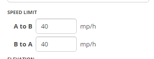
The speed limit fields can be found in the Left pane with one or more segments selected.

- These fields should be updated with the official speed limit as shown on speed limit signs.
- Make sure you’re using the correct units for the speed limits.
- Switch between Imperial or Metric in the Settings Tab [Link to Settings tab explanation].
- The Gear icon is only visible when no segment or place is selected.
- Adding Speed Limits must be based on certainties. You should be familiar with the area where you add them. A manually entered speed is regarded as confirmed. Incorrect speeds have a negative affect on the algorithm that will be created by Waze.
Phased roll-out
The roll-out of speed limits is planned in three phases, as explained below:
- Phase 1 - initial speed limit data (by community)
- Minimum 10 000 segments on a localized area (e.g. city)
- With all types of roads
- Most importantly all types of speeds that exist in the country should be present.
- Phase 2 - prediction algorithm (by Waze)
- Wait for the Waze Team to generate Speed Limit predictions for all the country / metro. This takes a few business days
- Phase 3 - speed limit verification (by community)
- Verify the inserted speed limits by the Waze algorithm (use the ‘Verify’ checkbox inside the Editor). Focus on high speed roads (Freeways, Major Highways, Minor Highways).
Tips & tricks
- Do not include multiple road types in one selection or the speed limit text boxes will be unavailable.
Scripts
The following external scripts can aid with entering speed limits. [Insert link to explaination about scripts]
- WME Speedhelper
- Designed to simplify the input of the speed limits
- https://greasyfork.org/en/scripts/13774-wme-speedhelper
- WME Speeds
- Can be used to visualise where the Speed Limits have been added.
- Shows the Speed Limit of each segment using a color code.
- https://greasyfork.org/nl/scripts/12402-wme-speeds
- WME Color Highlights
- Version 2.3 (and later) supports highlighting of segments without verified speed limits.
- https://greasyfork.org/en/scripts/3206-wme-color-highlights
- Street Vector Layer
- Can be used to visualise where the Speed Limits have been added.
- Shows the Speed Limit of each segment using a color code.
- https://www.waze.com/forum/viewtopic.php?f=819&t=149535